 Poster: A snowHead
|
Sure, but bit stunned you have chosen to deliberately quote me out me out of context? Not sure why.
Maybe this from Tuesday...
"Latest GFS is suggesting a relatively high freezing level on Sunday"
|
|

|
|
|
|
Obviously A snowHead isn't a real person
Obviously A snowHead isn't a real person
|
4100m on monday, thankfully not for long 
|
|
|
|
|
|
Well, the person's real but it's just a made up name, see?
Well, the person's real but it's just a made up name, see?
|
| nozawaonsen wrote: |
Sure, but bit stunned you have chosen to deliberately quote me out me out of context? Not sure why.
|
Sorry you've lost me there. I was quoting the SLF forecast that you posted which says rain to 2000 meters.
|
|
|
|
|
|
You need to Login to know who's really who.
You need to Login to know who's really who.
|
@Little Martin, around 3,800 to 4,000 is showing on a few models for many French / Italian resorts on Monday for a brief period.
Don't think that's the issue as opposed to the winds. Though if you look at winds in resort at say 1,556 (Tignes) 15km and then at altitude 45km although I see both wind speeds and snowfall for Sat/Sun have fallen back.
What is quite bizarre are the predicted snow levels for Chamonix vs neighbouring resorts such as Les Saises / Carroz - think Cham tourist board have been throwing a few backhanders out to some forecast sites 
Way way too far off, but currently a bit of a "retour Est" for the Queyras on the cards for weekend after next ?
And Alpes Maritimes and Southern Alps seeing more than a dribble ?
Watch that all change as we get nearer!
Off to find some more spring snow later this morning, though high wispy cloud could be a factor, though with cloud temps did not drop too much overnight.
Not bothering with CAF tour that was proposed for Sunday, and when I said to the "leader" last night "what about the rain" he just did a classic Gallic shrug, mind you I don't think anyone else signed up for it instead opting for the "sortie cool" tomorrow as well as building a shelter ("exercice DVA, pelletage, comment établir un point chaud victime avec des skis,") with a washing line, could be useful for Sunday 
@nozawaonsen, and thought that was my prerogative to quote you (supposedly) out of context = that's a joke / banter
|
|
|
|
|
|
Anyway, snowHeads is much more fun if you do.
Anyway, snowHeads is much more fun if you do.
|
|
Chamonix meteo sees P/N limit at 1500 rising to 2000m Sunday. Seems reasonable. My only decision now is which day next week to drive home to UK. Need a dry day. Meanwhile today and tomorrow look good for seeing something of the dog sled race based in this area for a couple of days. The last few weeks have been terrific. Great snow and plenty of sun. Might turn out to have been the best weeks of the season.
|
|
|
|
|
|
You'll need to Register first of course.
You'll need to Register first of course.
|
| pam w wrote: |
| ......have been the best weeks of the season....... |
Maybe for you!
Though I agree has been a very good week for our friends, but they are not powder hounds / on an off piste course etc etc
That said the Spring snow we've skied off the back this week has been very good.
Anyway we still have all of February, March and April yet !!!
And UK weather sounds a tad windy - with the strongest winds in the North / Scotland but we could well see 50mph gusts on the South Coast.
This is a blatant link @nozawaonsen, to my weather station on the beach where weather data is uploaded every minute
Current Weather at : 8:40
Date 29/01/16
Wind WSW at 31.0 mph
5 min average top wind speed: 37.0
10 min average top wind speed: 37.0
Highest Gust past 24hrs: 38.0 at 7:06
Wind Chill: 4.4 °C
Pressure: 1020.5 Falling Slowly
Temperature: 10.0 °C
Sunrise: 7:40
Sunset: 16:46
There is also a archive so you can see historical data / trend
|
|
|
|
|
|
|
|
|
@Weathercam, cham meteo, which is an individual quoting 40-60 at 2500m for Sunday. Weather Pro which is a machine and not subject to any tourist office pressure suggesting 44mm. FL will be the killer.
They both sound a lot but here's hoping.
The graph also strongly agreeing.
|
|
|
|
|
|
|
|
| jbob wrote: |
cham meteo, which is an individual quoting 40-60 at 2500m for Sunday. Weather Pro which is a machine and not subject to any tourist office pressure suggesting 44mm. FL will be the killer.
|
It does seem to be a sizeable storm blowing through and there should be quite a bit of snow > 2000 m. Lets hope the FL comes down a bit though. We've just had a whole week of FL > 2000m, night and day. For the Isere this FL is being given: iso 0°: 1900->2400m which would correspond to what Noz (and Pam) posted. If there is significant rain below 2000m it will kill a lot of the skiing around near me but could be a bonanza for the high resorts on Monday with a nice temperature inversion, cloud sea and tropical temperatures.
|
|
|
|
|
|
You'll get to see more forums and be part of the best ski club on the net.
You'll get to see more forums and be part of the best ski club on the net.
|
|
Interesting the latest GFS run seems to have accelerated the storm front ahead by 12 hours lessening the amount in the NW alpes for the 3rd.
Last edited by You'll get to see more forums and be part of the best ski club on the net. on Fri 29-01-16 11:24; edited 2 times in total
|
|
|
|
|
|
|
|
|
|
|
snowHeads are a friendly bunch.
snowHeads are a friendly bunch.
|
|
@bruisedskier,? 06z still has the storm arriving Saturday evening. FL fluctuating with GFS less positive but ECM more positive I think over recent runs (switched). Still warming Sunday into Monday, so front arriving earlier would be better but don't see that in GFS 06z.
|
|
|
|
|
|
And love to help out and answer questions and of course, read each other's snow reports.
And love to help out and answer questions and of course, read each other's snow reports.
|
More snow now for Kitzbuhel in the storm forecast on both snow forecast and bergfex (I know they use different models - one GFS and one ECM I assume). Or, rather, more snow at the top; snow at the bottom turning in to rain...
And a lot more snow at all levels Weds/Thursday
|
|
|
|
|
|
|
|
|
@jbob, most automated sites run figures from the GFS Hauptlauf (thick green line). It does appear to be the most optimistic of the outcomes in terms of precipitation by some significant margin. Fingers crossed.
|
|
|
|
|
|
You know it makes sense.
|
@waynos, i will be watching with interest. we will now be 4, not 2 at half term 
|
|
|
|
|
|
Otherwise you'll just go on seeing the one name:
Otherwise you'll just go on seeing the one name:
|
|
Still looking good for most of the alps from around 4th onwards in FI based on 06z.
|
|
|
|
|
|
Poster: A snowHead
|
|
@davidof, where this at doe?
|
|
|
|
|
|
Obviously A snowHead isn't a real person
Obviously A snowHead isn't a real person
|
@Millom, My comment was really that 06z seems to have spread this out more, and wondered if this was the affect of Gertrude.
I was looking that the GFS 025 map diagram, as it was updating from 0 to 6, and I could see the front arriving earlier for the 3rd.
|
|
|
|
|
|
Well, the person's real but it's just a made up name, see?
Well, the person's real but it's just a made up name, see?
|
|
Morris reckons next mid week to weekend bring us cold and snow, watching with interest as this potentially coincides with a gap in my diary. Would that be midterm anywhere do people know?
|
|
|
|
|
|
You need to Login to know who's really who.
You need to Login to know who's really who.
|
|
|
|
Anyway, snowHeads is much more fun if you do.
Anyway, snowHeads is much more fun if you do.
|
|
|
|
You'll need to Register first of course.
You'll need to Register first of course.
|
So just reading the last few pages it looks like snow this weekend for Les gets with the chance of high snow line and rain in resort and potentially lower slopes. Then come wed/thurs quite a lot of snow.
I am going out there early Tuesday morning until Friday night. So could a bit of a mixed bag.
|
|
|
|
|
|
|
|
Marcialonga in Italy, 70km of cross country trails on artificial snow cover

|
|
|
|
|
|
|
|
|
Lots of squiggles from 7th onwards. When can I start getting excited about this (we're out 7th-14th, northern alps)?
|
|
|
|
|
|
You'll get to see more forums and be part of the best ski club on the net.
You'll get to see more forums and be part of the best ski club on the net.
|
|
@davidof, that does look rather dispiriting. I think I'd rather go for a walk. Les Saisies has 120kms of Nordic pistes surrounded by masses of natural snow. So walking, except on raquettes, is impossible.
|
|
|
|
|
|
|
|
|
Hi - what are the prospects looking like for Dolomites ( corvara) over next 7-10 days.
|
|
|
|
|
|
snowHeads are a friendly bunch.
snowHeads are a friendly bunch.
|
Hi We are coming to the Borovets on the 6th Feb and like some other people I am a bit worried about the lack of snow before then. Will we still be able to ski?
The resort looks really good for nervous skiers like myself. I'm just hoping the snow will still be good then. I like a soft landing. We have never been here before and I hear the slopes are good for people like me. I hope to gain more confidence with skiing during this week. I think the instructors are going to need to have a lot of patience with me..
Jane
|
|
|
|
|
|
And love to help out and answer questions and of course, read each other's snow reports.
And love to help out and answer questions and of course, read each other's snow reports.
|
| Spyglass wrote: |
| Hi - what are the prospects looking like for Dolomites ( corvara) over next 7-10 days. |
This is how Bergfex have it...just a dusting on Sunday 31st with mild temps and a high snowline, so thankfully pistes won't be drenched with rain like is possible with lower areas in France & Austria...better prospects for up to 10-20 cm midweek, Wed-Thurs 3rd/4th Feb, down to low levels. It won't be a game-changer for off-piste, but should freshen things up nicely.
http://www.bergfex.com/alta-badia/wetter/prognose/
Further off into FI, week commencing 7th Feb is looking quite promising with cold temps and hints of potentially large snowfalls. These keep shifting around and may amount to nothing, but worth keeping an eye on.
http://www.meteociel.fr/cartes_obs/gens_display.php?ext=1&lat=46.5&lon=11.9
Last edited by And love to help out and answer questions and of course, read each other's snow reports. on Fri 29-01-16 17:46; edited 1 time in total
|
|
|
|
|
|
|
|
|
@bruisedskier, GFS 12z has front arriving on Wednesday morning (from the North) and departing in the East early Friday but then with a new front arriving from the North-West on Friday evening. The front at the weekend seems much as before (GFS 06z) perhaps with some small changes in temp and precipitation in some places. Looks like their should be some nice snowfall figures showing for 12z from 3rd+ so hopefully this will stick around over the next few days (I think it gone back and forwards on amounts but consistent for lower temps and some snowfall over this period in FI).
|
|
|
|
|
|
You know it makes sense.
|
12z GFS builds a Genoa low overnight on Thursday.

This would be interesting as it would mean snowfall on the southern side of the Alps (bringing fresh snow to the Dolomites).
|
|
|
|
|
|
Otherwise you'll just go on seeing the one name:
Otherwise you'll just go on seeing the one name:
|
|
noza, how do you know it would be the southern side of the alps, is it just because the warmer high pressure sits to the south of the low pressure off genoa?
|
|
|
|
|
|
Poster: A snowHead
|
@eddiethebus, no, the low pressure system develops very early on Thursday morning near Genoa (hence the name). It then tracks across northern Italy. This would potentially draw moisture up from the Mediterranean before it hits the southern Alps. That said as currently modelled the low pressure system heads down the Adriatic. Better for snow would be if it headed more towards the Alps as it moved (so more north than south).
The northern side of the Alps also gets snow next week. I was just flagging up the potential for the south since it's been rare so far this year.
|
|
|
|
|
|
Obviously A snowHead isn't a real person
Obviously A snowHead isn't a real person
|
|
|
|
Well, the person's real but it's just a made up name, see?
Well, the person's real but it's just a made up name, see?
|
|
|
|
You need to Login to know who's really who.
You need to Login to know who's really who.
|
| nozawaonsen wrote: |
And moving onto next weekend more stormy weather driven from the NW with potential for good snowfall to low levels Saturday night into Sunday.
|
Excellent, just what's wanted. They won't even show up in these numbers which look good by themselves.
Been some great skiing last couple of weeks but could do with some more snow now.
.
|
|
|
|
|
|
Anyway, snowHeads is much more fun if you do.
Anyway, snowHeads is much more fun if you do.
|
Superhandy Buchanan thanks
|
|
|
|
|
|
You'll need to Register first of course.
You'll need to Register first of course.
|
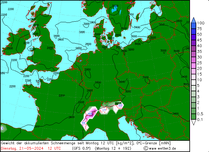
Current FL predictions for the Isere.
iso 0°: 2000 (Sunday am) -> 2600m (Sunday pm) -> 4200m (Monday)
|
|
|
|
|
|
|
|
|
^^^^^literally the grim reaper of this thread
|
|
|
|
|
|
|
|
| nozawaonsen wrote: |
| @eddiethebus, no, the low pressure system develops very early on Thursday morning near Genoa (hence the name). It then tracks across northern Italy. This would potentially draw moisture up from the Mediterranean before it hits the southern Alps. That said as currently modelled the low pressure system heads down the Adriatic. Better for snow would be if it headed more towards the Alps as it moved (so more north than south)............ |
As I mentioned further up the page......
| Weathercam wrote: |
Way way too far off, but currently a bit of a "retour Est" for the Queyras on the cards for weekend after next ?
And Alpes Maritimes and Southern Alps seeing more than a dribble ?
Watch that all change as we get nearer!
|
As I often bang on about snow predictions can be so wrong, never taking into account local effects / topography.
Such is the case of the Retour d'Est which can see substantial snowfalls in a very small area.
I've been there and experienced it, going from one valley to another in the Queyras and snow depths going from 30cm to 130cm in 10kms.
The Retour d'Est is a recognised Meteorological phenomenon in France
And the Gulf of Genoa is mentioned
Ils se produisent lorsqu’une dépression se creuse sur le golfe de Gênes
And if you search on here there are a few threads about it http://snowheads.com/ski-forum/viewtopic.php?p=2696611&highlight=retour#2696611
Like I say way to early to get too excited, but worth monitoring...........
Up early to hook up with the CAF for a ski tour, but conditions overnight not good from the looks of things, plus in my view, we're starting way too early as snow needs to transform.
Cracking day yesterday, Spring tour heaven (again), see Serre thread!
|
|
|
|
|
|
You'll get to see more forums and be part of the best ski club on the net.
You'll get to see more forums and be part of the best ski club on the net.
|
SLF forecast for Switzerland.
"Weather forecast through
Saturday, 30.1.2016
Following a night of predominantly clear skies it turned increasingly overcast during the course of the day. In the afternoon, snowfall set in from the west. The snowfall level is at approximately 1500 m.
Fresh snow
Only a few centimeters in the furthermost western regions.
Temperature
At midday at 2000 m, +2 °C in northern regions and -1 °C in southern regions.
Wind
Winds will be westerly to southwesterly, intensifying significantly in velocity during the course of the day:
On the northern flank of the Alps and in the western and northern parts of the Valais, winds as of midday will be blowing at strong to storm strength; in the Prealps this wind intensity will also extend down to intermediate altitudes.
In the southern part of Upper Valais, in Grisons and in Ticino, winds will not reach strong velocity at high altitudes until evening.
Outlook through Monday, 1.2.2016
Sunday
In northern regions snowfall is anticipated which will be intense and heavy. The snowfall level is expected to ascend from approximately 1500 m up to over 2000 m in western regions; and from approximately 1300 to 1800 m in eastern regions.
In the Valais, on the northern flank of the Alps and in northern Grisons, 30 to 60 cm of fresh fallen snow is expected. Winds will be westerly, blowing at storm velocity.
The danger of dry and wet avalanches will increase rapidly and significantly in northern regions.
Monday
Throughout Sunday night, the snowfall is expected to persist. During the daytime on Monday, it will swiftly become sunny and very warm from the west.The avalanche situation is expected to remain treacherous."
|
|
|
|
|
|
|
|
|
Not so hopeful for Kitz now; the snow that will be washed away tomorrow does not now look like being replenished much midweek, and temps midweek are higher than before too... Maybe next weekend will do the trick...
|
|
|
|
|
|
|
|


