Can I ask a really pedantic question about an earlier post please?
"Up to 144 hours and further in the future: 45-55% of all the cases are correct".
I am not sure what "correct" means. Am I looking at a toss of the coin in which case 50% correct means 50% heads and 50% tails ie incorrect? In which case the forecasts beyond 144 hours are a waste of space?
Sorry to be simple.
Obviously A snowHead isn't a real person
Obviously A snowHead isn't a real person
@JuanPlank, yes it was meant as a response to @rrd3718, sorry was distracted.
@langball, like @hd, says it was simply trying to capture that both major models are consistent in forecasting cold out till early December (02/12). Since ECM doesn’t go beyond that and since you are then into the further regions of FI it’s hard to take output beyond that especially seriously though for what it’s worth GFS does continue the cold theme.
The mean does of course include outliers in terms of the data it uses, but my point was that as it then averages this out the outliers effectively disappear. That’s good in that it smoothes the data, but bad as the outlier could well be the important part.
Well, the person's real but it's just a made up name, see?
Well, the person's real but it's just a made up name, see?
@countryman, beyond about 5-7 days you are generally more likely looking to see broad trends rather than having much confidence in the accuracy of a specific forecast for a specific location.
Anyway, snowHeads is much more fun if you do.
Anyway, snowHeads is much more fun if you do.
Loving the banter - quick hi to all posters and fellow lurkers. Thank you all for your input, I don't know about anyone else but I hoover it up from early November (whenever that is). Here's hoping for a heroic season for all whether you be on the piste, off the piste or on the apre.
Hear hear! http://wepowder.com/en is reporting a decent amount over the next few days for lots of resorts. What model do they use and are they reliable?
Then you can post your own questions or snow reports...
Then you can post your own questions or snow reports...
Pendandtic schamantic....outliers don't disappear, they merely fade away.
Anyway, need to get out and enjoy the warm sun until we plunge into the freezer until at least xmas.
Look how happy these people are....the guy in the red shirt at 1min has similar moves to me....roll on sunday snow
Family likes to ski before the Christmas holiday...get out b4 it gets crazy. Generally that means colorado. This year JH targhee and whistler are the too obvious candidates. This forecast firms up and maybe our first ever pre-Christmas european jaunt. Zurs looking appropriate but may try and find something truly quiet. Very iffy but awesome to be considering alps this early.
You'll get to see more forums and be part of the best ski club on the net.
You'll get to see more forums and be part of the best ski club on the net.
GFS 12Z op run looks a tad cooler for Friday night into Saturday as the front approaches, if my amateur interpretation is correct. If that can knock the freezing level down a smidge so we wake up to snow not rain on Saturday morning it would be much appreciated thank you please
Ski the Net with snowHeads
Ski the Net with snowHeads
gsmyth555 wrote:
Hear hear! http://wepowder.com/en is reporting a decent amount over the next few days for lots of resorts. What model do they use and are they reliable?
GFS (which isn't reliable in itself beyond 5 days) and Not really.
snowHeads are a friendly bunch.
snowHeads are a friendly bunch.
@BobinCH, your ‘weekend warriors’ comment just prompted me to get out the old Blizzard of Aahhs dvd and watch the ‘warriors of the wasteland’ section. Love it!
And love to help out and answer questions and of course, read each other's snow reports.
And love to help out and answer questions and of course, read each other's snow reports.
Quote:
Yes, I know. I had a great time there chez Tatman.
So if you're just off somewhere snowy come back and post a snow report of your own and we'll all love you very much
So if you're just off somewhere snowy come back and post a snow report of your own and we'll all love you very much
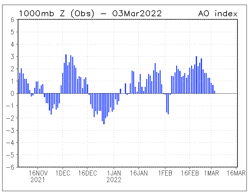
As @Jellybeans1000, flagged up a while back the AO and NAO have both shifted negative. The AO especially.
You can also see the jet driving further south.
That allows cold to pour down from the north and also snow which should start reaching the southern Alps in quantity as we go through the next 10 days.
Last edited by So if you're just off somewhere snowy come back and post a snow report of your own and we'll all love you very much on Thu 23-11-17 9:56; edited 1 time in total
You know it makes sense.
You know it makes sense.
GFS and ECM 00z runs both have the cold weather arriving this weekend lasting all week and up to at least 03 December (which is as far out as ECM runs).
Otherwise you'll just go on seeing the one name:
Otherwise you'll just go on seeing the one name:
nozawaonsen wrote:
GFS and ECM 00z runs both have the cold weather arriving this weekend lasting all week and up to at least 03 December (which is as far out as ECM runs).
Poster: A snowHead
Poster: A snowHead
Just a few observations to add this morning, then I'm off to the hills.
1. Someone questioned the stat about beyond 144hrs being only 50% reliable. Morris was referring to the snow maps in particular locations, not sure how much resolution he is applying, but would guess it's within 5km accuracy. The only other stats I've seen on model accuracy refer to the whole of the northern hemisphere. So when you see 89% quoted for ECM and 80% GFS, they are talking about the correlation of 500mb heights re-analysis across the entire NH at 144hrs. Easy to see why the accuracy will drop substantially the more you focus on specific location (like the tiny dot of an alpine village).
2. Thought this quote from NOAA was interesting, describing the upper trough (not sure why they write in capitals):
"....THE ECMWF IS TRENDING TOWARD A DEEPER SOLUTION, WHILE THE GFS RUNS FLIP FLOP
BACK AND FORTH. THE MEANS OF BOTH GLOBAL MODELS PRETTY MUCH
SUPPORT THE LATEST OPERATIONAL SOLUTIONS"
3. Some commentators on other sites were concerned that despite good looking chart synoptics for next week, the upper air temps (850's) are not particularly cold. One of the more valid responses discussed how arctic sea ice remains near record lows and SST (sea surface temps) to our north remain too high. Svalbard for example has been running above it's 30year average for several years now. Even though it's dropping next week to -7C, it will still be above it's long term average. So these factors make it harder for us to get really cold air into Europe even when we get northerlies / easterlies. But it's only mid november.
4. NAO/AO....am still not convinced they make much difference. For one thing they just reflect the current differences in pressure across 2 areas (ie they don't drive anything weather related). For the NAO the areas they look at are Iceland and Azores, both quite a long way from the alps, but important areas of course. For the example Noza gives above....isn't the NAO forecast to rise into month end? For your charts for the Jet (29th) and snow (30th), the pressure is equal between Iceland and Azores (1015mb) on those dates. So NAO neutral. While it's deeply negative right now (today), we have warm weather.
5. There are ECM charts beyond 240hrs. Personally I don't give much weight to anything beyond about 192hrs, but for those that wish to look further, this Icelandic site is handy. http://brunnur.vedur.is/kort/ec-ens/2017/11/
Go to latest date, pick 12z or 00z, then scroll all the way to the bottom and pick one of the scenarios. They run 2 suites, 192-240hrs, and 264-360hrs.
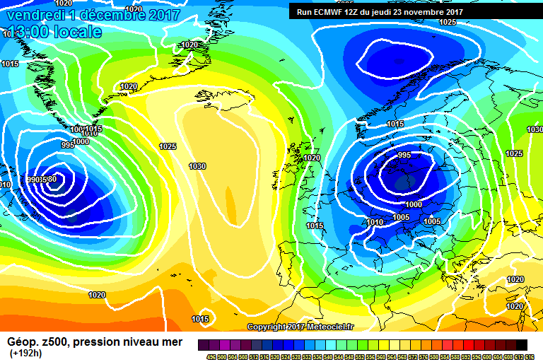
Here's the latest output for that first period, showing 2 good clusters of ensembles going for low pressure over Europe out to Dec 3rd approx. I would never take the extended period seriously, but for the record, it's showing high pressure creeping back over Europe further out.
Obviously A snowHead isn't a real person
Obviously A snowHead isn't a real person
Hope you have fun on slopes.
Yep the NAO or AO is just an index showing the relative positions of high and low pressure. So that in itself doesn’t drive anything. But the underlying conditions they describe (a primarily Atlantic driven set up or a primarily blocked set up for example) clearly do. That said translating that broad set up into actual weather for a specific area is not possible. And I too am pretty sceptical about attempts to use it in any long term way beyond perhaps indicating an increased probability of a certain type of pattern which may produce particular types of weather more often than not (so plenty of caveats).
When the mean supports the op confidence goes up whenthey diverge you have more of a puzzle to ponder.
Temperatures from this weekend look plenty cold enough. Already much chillier in Austria than last night.
Sure there are ECM charts that run out beyond 10 days, but I‘m too lazy to spend much time on them given as you say the marginal benefit they add!
Well, the person's real but it's just a made up name, see?
Well, the person's real but it's just a made up name, see?
Chamonix Meteo forecasting 30-40cm,s on Saturday and at lower temps 😳 Meteo Suisse still only predicting about 15cm in Verbier. I’m rooting for the French 🇫🇷
SATURDAY NOVEMBER 25
Disturbance crossing over - getting colder
SW strong high up, veering west
SKIES : mostly cloudy to overcast. Period of sunshine close to 0%.
PRECIPITATION : continuous and moderate in the morning - turning into showers during the afternoon - rain-snow limit towards 1500 m in the morning, dropping towards 1000 m later - expected snowfall towards 1800 m : 30-40 cm, windblown.
WIND - en altitude : SW strong -> WSW strong to gale force.
TEMPERATURE : rising lows - dropping highs
Certainly going to be interesting to see how the weekend pans out.
I'm hoping we will not miss out (again) in Serre Che but does look better North of the Lautaret with La Grave getting more than here yet we're so close.
Though there is a glimmer of hope from some of the charts, but as ever can all change either way.
Have had a nice couple of tourettes this week anyway on closer deserted pistes, so no complaints.
Anyway, snowHeads is much more fun if you do.
Anyway, snowHeads is much more fun if you do.
Any forecasts for Austria for the weekend? Specifically Solden/Obergurgl?
Coverage on-piste is great. Basically everything open. Off-piste a bit thin...
Then you can post your own questions or snow reports...
Then you can post your own questions or snow reports...
langball wrote:
Just a few observations to add this morning, then I'm off to the hills.
1. Someone questioned the stat about beyond 144hrs being only 50% reliable. Morris was referring to the snow maps in particular locations, not sure how much resolution he is applying, but would guess it's within 5km accuracy. The only other stats I've seen on model accuracy refer to the whole of the northern hemisphere. So when you see 89% quoted for ECM and 80% GFS, they are talking about the correlation of 500mb heights re-analysis across the entire NH at 144hrs. Easy to see why the accuracy will drop substantially the more you focus on specific location (like the tiny dot of an alpine village).
2. Thought this quote from NOAA was interesting, describing the upper trough (not sure why they write in capitals):
"....THE ECMWF IS TRENDING TOWARD A DEEPER SOLUTION, WHILE THE GFS RUNS FLIP FLOP
BACK AND FORTH. THE MEANS OF BOTH GLOBAL MODELS PRETTY MUCH
SUPPORT THE LATEST OPERATIONAL SOLUTIONS"
3. Some commentators on other sites were concerned that despite good looking chart synoptics for next week, the upper air temps (850's) are not particularly cold. One of the more valid responses discussed how arctic sea ice remains near record lows and SST (sea surface temps) to our north remain too high. Svalbard for example has been running above it's 30year average for several years now. Even though it's dropping next week to -7C, it will still be above it's long term average. So these factors make it harder for us to get really cold air into Europe even when we get northerlies / easterlies. But it's only mid november.
4. NAO/AO....am still not convinced they make much difference. For one thing they just reflect the current differences in pressure across 2 areas (ie they don't drive anything weather related). For the NAO the areas they look at are Iceland and Azores, both quite a long way from the alps, but important areas of course. For the example Noza gives above....isn't the NAO forecast to rise into month end? For your charts for the Jet (29th) and snow (30th), the pressure is equal between Iceland and Azores (1015mb) on those dates. So NAO neutral. While it's deeply negative right now (today), we have warm weather.
5. There are ECM charts beyond 240hrs. Personally I don't give much weight to anything beyond about 192hrs, but for those that wish to look further, this Icelandic site is handy. http://brunnur.vedur.is/kort/ec-ens/2017/11/
Go to latest date, pick 12z or 00z, then scroll all the way to the bottom and pick one of the scenarios. They run 2 suites, 192-240hrs, and 264-360hrs.
Here's the latest output for that first period, showing 2 good clusters of ensembles going for low pressure over Europe out to Dec 3rd approx. I would never take the extended period seriously, but for the record, it's showing high pressure creeping back over Europe further out.
I do like those EC clusters, shows trends very well.....
I personally don't call 850hPa 'uppers', but each to their own. Warm SSTs and surface temperatures around Svalbard does limit options for very cold air, however warm SSTs and lack of sea ice does correlate with a -AO setup.
After all it is free
After all it is free
Judah Cohen is always worth a read on AO/NAO and the state of the polar vortex.
Increase in avalanche danger as a consequence of fresh snow and strong wind
“Weather forecast through Saturday, 25.11.2017
During the night skies will be variably cloudy, during the daytime heavily overcast for the most part. In the early morning hours in western and southern regions, precipitation is expected to set in which will subsequently reach all regions of Switzerland over the course of the day. During the afternoon, the precipitation will slacken off in southern regions. The snowfall level in northern regions and in the Jura will be at 1700 to 2000 m to start with, subsequently descend swiftly to 800 to 1000 m during the morning. In southern regions, the snowfall level will descend from 1400 m in the morning down to 1000 m.
Fresh snow
By Saturday evening above approximately 1800 m, the following amounts of fresh snow are anticipated:
furthermost western part of Lower Valais, northern flank of the Alps west of the Wildstrubel: 20 to 30 cm;
remaining regions of Switzerland: 10 to 20 cm over widespread areas;
Jura above approximately 1000 m: 5 to 10 cm; in western regions as much as 20 cm.
Outlook through Monday, 27.11.2017
Sunday
On the southern flank of the Alps it will be quite sunny as a result of the strong northerly wind. In other regions of Switzerland skies will be predominantly overcast and snow showers are anticipated. From the Bernese Oberland as far as northern Grisons, an additional 10 to 25 cm of fresh snow is expected. It will be cold and the snowfall will extend down to low lying areas. As a result of the strong northerly winds, fresh snowdrift accumulations can be expected to form. The avalanche danger will increase in northern regions more than anywhere else.
Monday
In northeastern regions skies will still be predominantly overcast and some final snow showers can be expected. In western regions skies will continue to brighten increasingly. In southern regions it will be sunny for the most part. The northerly wind will slacken off significantly, and for a short time temperatures will rise somewhat. The avalanche danger levels will incrementally decrease.”
Not too much going on down Sarf here in Serre - 10cms max above 2,300 and wind now howling in the valley so imagine that will all be in a heap somewhere by tomorrow morning.
Then you can post your own questions or snow reports...
Then you can post your own questions or snow reports...
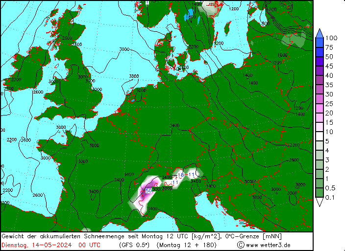
GFS 12z favours the eastern end of the Alps out till next Sunday.
After all it is free
After all it is free
ECM and GFS both going particularly cold next weekend into Monday. Chart below shows anomaly, so how much colder than average.
Last edited by After all it is free on Sat 25-11-17 20:04; edited 1 time in total
You'll get to see more forums and be part of the best ski club on the net.
You'll get to see more forums and be part of the best ski club on the net.
Rained all day in Engelberg and dumped above 1500m albeit quite heavy/wet snow. Much colder now though as forecast and big flakes coming down into town nicely. Mañana mañana
Certainly going to be chilly for a while. A very brief rise in temperatures (towards average for the time of year) tomorrow is just a prelude to the cold weather really taking control. And it looks like lasting. ECM and GFS have pretty solid consistency out to 06 December and GFS reloads in FI.
There will be snow too, more so on the northern side of the Alps. But with the Atlantic cut off we are not looking at huge snowfall. But slow and steady is good.
This shows the pressure anomalies. High pressure to the west locking out flows from the Atlantic. So very cold, but drier than it would be with a more Atlantic flow.


 Poster: A snowHead