 Poster: A snowHead
|
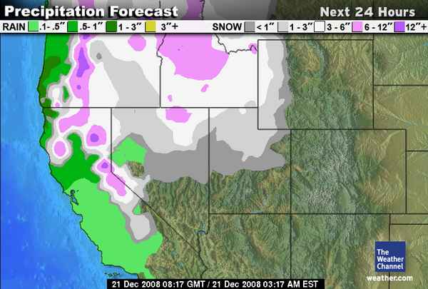
Sunday Dec 21
0100 PST
I'm back reporting from the eastern slope of the Sierra Nevada range.
After a below average beginning to the season, weather patterns have changed in a big way.
Other then a large storm we had over our Thanksgiving Weekend at the end of November, we had seen week after week of sun.
was very depressing.
we really didnt have much base left below 8000' and what was left was very faceted.
finally last week the blocking Rex moved east allowing a series of storms to roll in from the gulf of alaska.
Snowfall amounts since the series of storms began are in the 5-6 foot range for most of the crest.
Its snowing tonight as a very large moisture plume extends deep into the pacific.
Could be epic.
i will update.
|
|

|
|
|
|
Obviously A snowHead isn't a real person
Obviously A snowHead isn't a real person
|
|
|
|
Well, the person's real but it's just a made up name, see?
Well, the person's real but it's just a made up name, see?
|
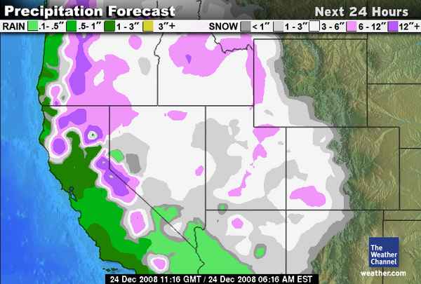
24 DEC
0430 PST
I'm up with the baby and thought i would make a report.
Awesome conditions up and down the US coastal ranges and continuing to improve.
A parade of pacific storm fronts has been rolling through about every other day.
South lake shows 18 inches reported at Heavenly in the last 24 hours.
reports of waist deep at the micro-climate around Kirkwood
which reports 9 feet of snow in the last 9 days!!
gobs of new snow here around the North Shore at Sugarbowl,
and around 2 feet of fresh at Mt Rose yesterday.
Its snowing right now and the forecast calls for snow.
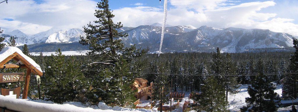
sorry no pics. except a screenshot off the weather channel.
Tahoe appears to have a bullseye right over it.
|
|
|
|
|
|
You need to Login to know who's really who.
You need to Login to know who's really who.
|
24 DEC 08
Christmas Eve
1844 PST
10 to 12 inches of moderate accumulating snow showers today.
from the NOAA reno office at 4pm today:
TRAVEL OVER THE SIERRA LATER TONIGHT IS NOT
RECOMMENDED AS STRONG WINDS WILL COMBINE WITH SNOW TO CREATE
LOCALIZED WHITE OUT CONDITIONS. SNOW AMOUNTS IN THE SIERRA STILL
EXPECTED TO BE UP TO A FEW FEET ABOVE 7000 FEET WITH AROUND A FOOT
IN SIERRA VALLEY LOCATIONS.
4 years in a row we have gotten pounded by 100+" weeks during christmas-new years,
and it looks like the streak is going to continue for a 5th.

|
|
|
|
|
|
Anyway, snowHeads is much more fun if you do.
Anyway, snowHeads is much more fun if you do.
|
|
I think the term snow 'showers' is underrated - It hasn't stopped snowing at Squaw since about 6am today (christmas eve) and I'm expecting a very slow drive home later tonight!
|
|
|
|
|
|
You'll need to Register first of course.
You'll need to Register first of course.
|
picked up about 24 additional inches at lake level (6300').
probably more up higher.
With high winds most of the resorts were holding off opening for a couple hours.
i just woke up from napping.
I'm at a loss for motivation.
|
|
|
|
|
|
|
|
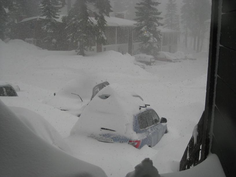
25DEC08
1928 PST
time to dig out
from earlier today
|
|
|
|
|
|
|
|
|
|
|
You'll get to see more forums and be part of the best ski club on the net.
You'll get to see more forums and be part of the best ski club on the net.
|
Rode Heavenly today.
was pretty nice 4 ft base, but many dangers still lurchs just below the snow.
found some stashes of boot deep powder in the elevations above 9000 ft.
many aspects are still very bony.
there are suppose to be some refreshers coming along soon.
fingers crossed
|
|
|
|
|
|
|
|
Feb 05/2009 : 1449
below average january has left The Sierra at around 2/3 of average so far going into Feb.
according to snowpack measurements concluded Feb1.
active pattern change came in the last 8 hours has seen snowshowers increasing south ahead of a front.
7000 ft snow level is forecasted to drop to lake level by 7pm PST
Mammoth Mt in the southern sierra looks to possibly have the best conditions coming into next week.
|
|
|
|
|
|
snowHeads are a friendly bunch.
snowHeads are a friendly bunch.
|
Mammoth reported 18-24" from thurs-fri's fast moving storm.
Locally around Tahoe has seen 6-12" north shore,
a little less along the west shore as you go by squaw and alpine,
heard heavenly received 12+,
and of course kirkwood did a little better then that.
Shortterm into Longterm forecast looking favorable.
|
|
|
|
|
|
And love to help out and answer questions and of course, read each other's snow reports.
And love to help out and answer questions and of course, read each other's snow reports.
|
tuesday, feb 10, 2009
1152 PST
Second storm in this series came thru sat/sun and additional snow amounts are impressive.
Alpine ghettos received about 24-30 inches bringing their storm total to over 3 feet.
Kirkwood total is a touch over 4 feet.
Mammoth to the south looks to have similar maybe a little heavier deposits as Kirkwood,
and at this point in the season has a very similar mid-mountain snow depth of around 130".
Mammoths upper lifts opened this morning to bluebird conditions for the first time since last thursday.
The stars have aligned and the 5 day forecast appears to include an additional 2-3 feet of local accumulation possible.
sweet
|
|
|
|
|
|
|
|
Wed 02-11-09
1958 PST
The initial cold front associated with the low pressure system off the west coast pushed a band of precipitation through the forecast area last night
adding another 4-7 inches of new snow to the snowpack.
Southwest winds increased late yesterday and remained in the mid to high 30's overnight.
A small break in the weather should occur during the day today with winds and snowfall decreasing.
As this low starts to move eastward another more intense wave of snow should reach the forecast area starting this evening
with 6-12 inches of accumulation expected overnight.
A small, short-lived high pressure ridge follows this storm during the day tomorrow
before a stronger, wetter low pressure system reaches the forecast area Thursday night.
reprinted from Sierra Avalanche Center website.
|
|
|
|
|
|
You know it makes sense.
|
Well,
it has been quite a week since the first system moved in on the 5th.
Kirkwood looks to be the winner around here with 7 day snow totals of 50-68"
not sure about Mammoth but the rest of Tahoe appears to have gotten around 4 feet total.
Interesting forecast reprinted from Snowforecast:
Friday and Saturday ->
Another low pressure system moves in with significant snowfall Friday and through Satuday morning. A fairly strong southwest flow aloft will help churn out. A very strong low pressure system moves in overnight, with heavy snow mainly starting early Sunday.
Sunday ->
Strong low pressure moves in with deep moisture, mid level instability, and strong orographics, cranking out classic Sierra cement, with multiple feet expected.
Monday and Tuesday ->
Lighter snow is expected both days, with some disturbances aloft expected. Very heavy snow may begin Tuesday afternoon or later, as a very strong and moist storm moves in.
--Next Tuesday night through Thursday (17th - 19th)
another low pressure system moves into the west and sends several impulses across the Sierras, for what looks to be a heavy snow event each day, really piling up. This may be followed by another possibly epic series of storms (very heavy snow) Friday through Sunday (20th - 22nd).
|
|
|
|
|
|
Otherwise you'll just go on seeing the one name:
Otherwise you'll just go on seeing the one name:
|
|
|
|
Poster: A snowHead
|
| laundryman wrote: |
3snowboards, 
Due out on 18th March.  |
15Feb09
0059PST
i bet you are almost counting down the days till that trip.
i'll have to check my calendar to see if im free to meet up and help your tour.
conditions are all-time at the moment.
long range weather forecast has been tilting towards stormy.
i think France has been hogging most of the snow this year.
wonder if they are willing to share.
todays sierra avalanche center's daily report.
14Feb09
(summarized and metric conversions added by me)
The latest in the steady progression of storm systems to affect the forecast area continues this morning. Snow showers and sun breaks are expected during the day today. Above 7,000' (2133m), an additional 10 to 14 inches (28-35cm) of new snow fell across the forecast area last night. This brings 24 hour snow totals at the upper elevations to 16 to 22 inches (40-60cm). Air temperatures in the single digits and teens this morning are expected to warm into the mid teens (-9c) and low 20s (-4c) today. Ridgetop winds out of the southwest became strong during the early morning hours, but are expected to decrease to moderate in speed as the day progresses.
Today, an additional 10 to 14 inches (28-35cm)of new snow on top of an already unstable snowpack will allow the possibility of natural and human triggered slab avalanches to continue. The greatest areas of instability and larger slabs are expected near and above treeline on wind loaded NW-N-NE-E aspects, 35 degrees and steeper. Below treeline, pockets of small slabs should be expected in steep open wind affected areas, especially above 8,000' (2834m). In steep open areas not affected by wind, human triggered sluff activity should be expected. A good window for natural avalanche activity occurred last night. Fresh crowns and debris may be observed in the backcountry today.
Today's Advisory:
Near and above treeline, avalanche danger is CONSIDERABLE on NW-N-NE-E aspects, 35 degrees and steeper. Below treeline, avalanche danger is MODERATE in open areas, 35 degrees and steeper.
|
|
|
|
|
|
Obviously A snowHead isn't a real person
Obviously A snowHead isn't a real person
|
|
Snow continues with most above treeline lifts shut down. Some decent spillover onto the eastern slope.
|
|
|
|
|
|
Well, the person's real but it's just a made up name, see?
Well, the person's real but it's just a made up name, see?
|
Sunday Feb 15, 2009
1719PST
NWS from earlier today:
...WINTER STORM WARNING IN EFFECT UNTIL 4 AM PST TUESDAY...
THE NATIONAL WEATHER SERVICE IN RENO HAS ISSUED A WINTER STORM
WARNING FOR HEAVY SNOW AND GUSTY WINDS...WHICH IS IN EFFECT UNTIL
4 AM PST TUESDAY. THE WINTER WEATHER ADVISORY IS NO LONGER IN
EFFECT.
* SNOW ACCUMULATION THROUGH TONIGHT: 6 TO 12 INCHES (15-30cm)...WITH 10 TO
20 INCHES (25-50cm) ABOVE 7000 FEET.
* ADDITIONAL SNOW ACCUMULATION FOR MONDAY AND MONDAY NIGHT: 6 TO
12 INCHES(15-30cm)...WITH 18 TO 30 INCHES (45-76cm) ABOVE 7000 FEET.
* WINDS: SOUTH TO SOUTHWEST WINDS OF 15 TO 25 MPH(24-40 kph) WITH GUSTS TO
45 MPH (72kph). SIERRA RIDGE GUSTS OF 80 TO 100 MPH (128-160kph).
* IMPACTS: PROLONGED PERIOD OF SNOW PACKED AND ICY ROADS WITH
VISIBILITY NEAR ZERO AT TIMES DUE TO SNOW AND BLOWING SNOW.
|
|
|
|
|
|
You need to Login to know who's really who.
You need to Login to know who's really who.
|
reprinted from Kirkwood resort website.
Updated as of Tuesday afternoon, February 17…
It has snowed all day, about 6-8 inches, still snowing, but the radar shows this storm track breaking up by this evening,
with mostly clear skies tomorrow, should be amazing.
We’ve received 30-36 inches in the past 36 hours, 112-142 inches since this all began 12 days ago.
All roads are open, and we expect no issues Wednesday morning. Most of the mountain will open for the first time in three days tomorrow morning
|
|
|
|
|
|
Anyway, snowHeads is much more fun if you do.
Anyway, snowHeads is much more fun if you do.
|
Thurs feb 19, 2009
1712 PST
Second of four days of bluebird in between another round of storms is what going on.
Today was the first day the big BC lines are considered safe.
Winds set to increase saturday ahead of change.
|
|
|
|
|
|
You'll need to Register first of course.
You'll need to Register first of course.
|
|
|
|
|
|
|
Well this is an off year but kirkwood is still approaching 300". Snow depth along the Sierra crest is around 90% of average right now. Some major storms are set to roll through next week so maybe we will be able to make up the shortfall in the second half of the season.
|
|
|
|
|
|
|
|
THURS
02-26-09
2332 PST
unsettled weather has continued with small amounts being recorded everyday up in the alpine.
a local was killed in a BC avalanche on saturday while touring solo and avalanche conditions are still elevated
for slopes over 35 degrees.
from Kirkwoods website today
Temperature 23
Wind Moderate
Today's Forecast light snow throughout the day
Snow Stats (snow totals in inches)
Last 24 hours 4-6"
Last 7 days 29-40
Season Total Range 241-305"
Mid Mountain Base 110-166"
from NOAA reno office website. i only kept the good parts. and took out the scientific hogwash
SHORT TERM...
A FEW SNOW SHOWERS ARE POSSIBLE IN THE SIERRA THIS
EVENING BUT NO ACCUMULATIONS ARE EXPECTED.
SAT-SUN
THE SOUTHWEST FLOW AHEAD OF THE PACIFIC LOW TAPS INTO SUBTROPICAL
MOISTURE THERE IS POTENTIAL FOR UP TO 2
FEET OF SNOW ABOVE 7000 FEET IN THE SIERRA BY MONDAY MORNING
LONG TERM...MONDAY THROUGH THURSDAY...
ACTIVE PATTERN WITH GRADUAL COOLING TREND LIKELY THRU NEXT WEEK.
MULTIPLE SHORTWAVES MOVING ONSHORE AROUND THE BASE OF THE MEAN TROF
WILL TAP INTO PACIFIC MOISTURE AND SPREAD POTENTIALLY SIGNIFICANT
SNOW ACROSS THE SIERRA FOR SEVERAL DAYS.
IF ALL OF THESE COOL AND WET SYSTEMS IMPACT THE SIERRA NEXT WEEK AS
INDICATED BY THE 12Z GUIDANCE ...SNOWPACK TOTALS COULD RECOVER TO
NEAR SEASONAL AVERAGES BY NEXT WEEKEND. MJD
|
|
|
|
|
|
You'll get to see more forums and be part of the best ski club on the net.
You'll get to see more forums and be part of the best ski club on the net.
|
It's snowing today in Tahoe! Kirkwood has already got 6 inches so far (it was snowing really hard when I left today at 3pm) and it is snowing hard now at Heavenly.
Powder Day tomorrow!
|
|
|
|
|
|
|
|
It's bloody pissing rain right now in South Lake Tahoe. Was advised that going to Kirkwood would be a waste of time today, so against my better judgement aborted a hopeful sortie to see if there were any spaces on the shuttle bus. Then watched the web reports to see Kirkwood open up and out and Heavenly to pretty much shutdown! Anyway hadn't planned to ski today so not to put out about it.
Hopefully Highway 88 will go in the morning and the 80mph wind in the forecast will hit only Heavenly! 
|
|
|
|
|
|
snowHeads are a friendly bunch.
snowHeads are a friendly bunch.
|
|
Rode up to Heavenly yesterday and saw the mountain was on windhold so drove over to Kirkwood. Was totally the right decision. Really strong winds there but with snow. Was really nice in the afternoon. I live at 7300 ft elevation and we got rain and snow over night which means up at the lifs at 7800ft there was snow. Heavenly claims 8 to 10 inches last night.
|
|
|
|
|
|
And love to help out and answer questions and of course, read each other's snow reports.
And love to help out and answer questions and of course, read each other's snow reports.
|
Kirkwood Shuttle was fully booked Mon and Tues, so booked it up on Wed and Friday. Had a resonably decent day at Heavenly, but it paid to stay high up where the snow was fairly dry, got completely and utterly soaked by skiing down to Boulder Lodge for lunch where it was pissing it down, thought it would be a good bet for a more sociable munch with no trouble finding a seat.
Around the Olympic and Tamarack Express was the best place to be today, just high enough for the snow to be reasonably dry for most of the run, but no problems with intermittent wind-holds. Getting around some of the flat cat tracks to move around the mountain was a bit of a workout thanks to the sticky snow mid-mountain, so it paid to stick to the same area for a bit.
Skiing the Face below the Tram at the end of the day wasn't the best choice I've made on a mountain, one descent took more out of my legs than the entire White Lady Challenge on CairnGorm last Monday, the snow was seriously hard work, wet heavy knee renching muck piled up on a rather icy mogul field, in torrential rain! Standing outside California Lodge looking like a drowned rat I was able to wring the water out of my gloves without even taking them off....
Temps are coming down, snow is now falling in town in South Lake, powder days are coming up.
|
|
|
|
|
|
|
|
|
Colder air pushed in overnight, fluffy snow falling in South Lake Tahoe with a few inches of new snow lying in town. About 30inches fresh at Kirkwood in the past 24hours.
|
|
|
|
|
|
You know it makes sense.
|
|
|
|
Otherwise you'll just go on seeing the one name:
Otherwise you'll just go on seeing the one name:
|
Storming all day, but epic riding on the CA side of Heavenly on trail, on the groomers, in the trees, packed powder or tracked powder, or deep powder, something for everyone up there and all beautiful snow. Went up from the California Lodge base and stayed on the CA side today as the Sky and Tamarack Express chairs both closed due to the wind, but limitless options off the Canyon, Powderbowl and Gunbarrel Chairs. The Face was vastly more enjoyable today than yesterdays horror mush show in the rain!!
Will post some pics later, anyone posting in this thread in the vicinity of Fire & Ice in the Heavenly Village tonight, lookout for a Winterhighland Beanie!
Kirkwood tomorrow, should be off the scale as they open up and out with winds forecast to easy early Wed AM. Highway 88 closed both ways at present, fingers crossed Cal Trans win the battle during the night! 
|
|
|
|
|
|
Poster: A snowHead
|
|
|
|
Obviously A snowHead isn't a real person
Obviously A snowHead isn't a real person
|
|
I need fatter skis!
|
|
|
|
|
|
Well, the person's real but it's just a made up name, see?
Well, the person's real but it's just a made up name, see?
|
|
I just want to say that Monday through Thursday at Heavenly has been sick! Each day kept getting better and better!
|
|
|
|
|
|
You need to Login to know who's really who.
You need to Login to know who's really who.
|
|
|
|
Anyway, snowHeads is much more fun if you do.
Anyway, snowHeads is much more fun if you do.
|
The region has been blessed with the usual sunny weather and the occassional small storm.
Average snowpack on the north shore @ 8200 ft (2500m) is around 140" (3.5m)
Kirkwood and Mammoth mountain 100 miles (160km) to the south are reporting up to 190" (4.8m) base.
Some good storms are possible going to hit in the next week, setting us up for a good spring corn fest.
|
|
|
|
|
|
You'll need to Register first of course.
You'll need to Register first of course.
|
|
Moisture continues to assault the Sierra Nevada (and not the beer). Snow levels haven't dipped below 5000', which is ok since lake level is over 6000'.
|
|
|
|
|
|
|
|
|
Kirkwood got about 20 inches of snow over the last couple of days. Heavenly got a few inches. We are getting a warm front here now. Today was warm 50F degree weather.
|
|
|
|
|
|
|
|
|
Winter retains a firm grasp in the tahoe basin. Recent snow level in the area has been below the 4000 foot level.
|
|
|
|
|
|
|
|


 [/img]
 [/img]

