Sorry, I may have not been clear in the message! Yep, I was talking about Soldeu in the Pyrenees
Anyway, snowHeads is much more fun if you do.
Anyway, snowHeads is much more fun if you do.
Omega blocks are fairly common in early / late season, we highlighted one in each of Sep, Oct, Nov this season already, the key is always whether they can reach a high enough latitude to advect cold air from the E/NE into the alps/uk, and how long can the high stay elevlated. I don't have any data on them but I imagine they are less common in January, as this is the strongest month for westerly vortex influence, so any blocking in the north atlantic often gets quickly swept away. Likewise for Scandl blocking, you tend to see these patterns more in early and late season (spring) as the vortex is either in it's infancy or final decline.
But the PV is relatively weak this year so far, maybe helped by -QBO phase, and it has also been under attack from tropospheric patterns, ie ural high / aleutian low.
Here is the strat temp profile at 10hpa currently, huge amount of warming over the arctic, leading to a split vortex.
Sat 6th updated trop chart.....good match from the 3 means shown last Sat
From there it really starts to gain elevation.....leading to this by sunday night, also from ECM
I've never seen one last 10 days mind you, normally they are more like 3-4 days before either toppling/sinking or getting undercut. Of course they could reform after another few days so it depends how you view the whole period I suppose. It's too far to say how this one will evolve but mid range charts have all hinted at retrogression towards Greenland into mid Jan, which would be ideal. The initial block will bring in severe surface cold, so if we can then see the block migrate W/NW, it will open the door for better snow chances from the north.
So by next mon I think we'll get an undercut attempt, GFS and GEM this time showing the isobars linking up in the south atlantic. These are just mean anomalies though, the Omega pattern is still visible on the 500 geopots. And we know the models nearly always struggle with these set ups, undercuts especially tend to be mostly of the phantom variety.
5 different models showing the range of positions by mon-tues all showing disturbance over alps
From there I think the high will sink briefly and reform nearer to Greenland....here are the 3 means at day 10 looking remarkably similar. Would be dry and cool under that monster high.
So decent cold spell coming up, should be several good snowfalls, ISO down to 1400m thurs and then 1200-800 over weekend basis NW and potentially much lower next week (400-0) but drier.
Then you can post your own questions or snow reports...
Then you can post your own questions or snow reports...
OK, Xmas and New Year have come and gone so it's time for me to start working myself up into a froth about skiing, something I've not paid much thought to for 9 months or so (after having to cancel a ski holiday at the last minute last year).
So, I hope people don't mind my being lazy and asking how things are doing so far this winter in Austria by comparison with most years? Heading to Mayrhofen in March and it would be nice to think a decent base is building up (although I know a lot can and will happen between now and then).
After all it is free
After all it is free
Meanwhile right now it's raining steadiy at Les Menuires/ Bruyeres, 1850m
You'll get to see more forums and be part of the best ski club on the net.
You'll get to see more forums and be part of the best ski club on the net.
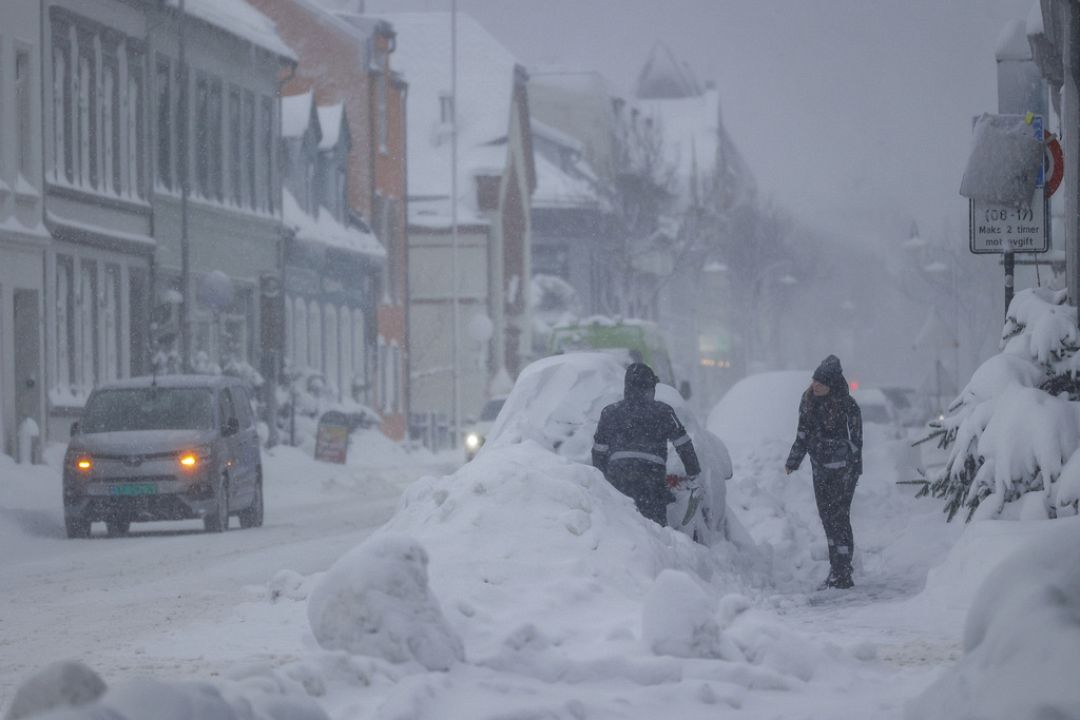
As predicted, rain is hammering down this evening below 1500-1900m in the Western Alps.
Snow above 2000m.
Head high on Weds.
Watch the wind.
Snows return on Fri in the Western Alps.
Saturday snow in the Eastern Alps.
Pyrenees will get some badly-needed snow.
Looks like a powda weekend in parts of Italy and elsewhere.
Beware of avalanches. Rain, wind, and snow don't mix.
Going by MeteoBlue a snowy and cold weekend ahead for Austria, the Dolomites and eastern Swiss Alps. At least a foot of the whitestuff.
And love to help out and answer questions and of course, read each other's snow reports.
And love to help out and answer questions and of course, read each other's snow reports.
@Snow&skifan, 20-40cms in Chamonix. I'd better get my terrace swept today (builders) or it won't be for a while
So if you're just off somewhere snowy come back and post a snow report of your own and we'll all love you very much
So if you're just off somewhere snowy come back and post a snow report of your own and we'll all love you very much
Interesting swing in wepowder's models, lots more for the Dolomites. Other websites (bergfex and snowforecast) if anything seem to have dialed the snow there back a bit.
Suspect wepowder's narrative may be different to its numbers.
You know it makes sense.
You know it makes sense.
@8611, I heard on the grapevine that local weather forecasters/snowfall modellers are struggling because of climate change. They've apparently binned the old models because they don't work anymore, and are working on developing new ones. This problem likely stretches further than Tirol.
@8611, I heard on the grapevine that local weather forecasters/snowfall modellers are struggling because of climate change. They've apparently binned the old models because they don't work anymore, and are working on developing new ones. This problem likely stretches further than Tirol.
I would be interested to see where you saw that information, as it doesn't make a lot of sense to me. Numerical weather prediction models use the laws of physics to predict a future state of the atmosphere. It doesn't matter if the atmosphere is warm or cold, they will provide an answer according to the laws of physics. The only exception is that the various models will have their own characteristics usually determined by the way the models analyse initial data and solve the laws of physics, or the way they parameterise some processes. This is why different models give different solutions. I can understand that climate change has had an impact on local forecasters reliance on previous climatology that suggests that certain events usually happen at certain times, but because of climate change, that is no longer the case.
Obviously A snowHead isn't a real person
Obviously A snowHead isn't a real person
I understand little or nothing about models, but I kind of thought that they and the people who pull their strings had a capacity to learn, by processing vast amounts of empirical data describing "what actually happened".
But that might be too simplistic!
Well, the person's real but it's just a made up name, see?
Well, the person's real but it's just a made up name, see?
8611 wrote:
Interesting swing in wepowder's models, lots more for the Dolomites. Other websites (bergfex and snowforecast) if anything seem to have dialed the snow there back a bit.
Suspect wepowder's narrative may be different to its numbers.
Also wepowder and the resort website (Passo San Pellegrino in Dolomites) actually have the freezing level super high - close to 2000m.
Bergfex is much lower, below 1000m. Snowforecast is between the two.
I understood that there weren't actually that many base models - 2 or 3. But can't remember where I read it and though I had a go I struggled to verify it.
Anyway, snowHeads is much more fun if you do.
Anyway, snowHeads is much more fun if you do.
The Dolomites ... for Corvara (1,568m) they forecast the following maxima:
Friday -1c - by my estimates giving a FL of circa 1,418m, 15cm snow.
Saturday 0c - FL 1,568m, 25cm snow.
Sunday - 2c - FL 1,268m
Monday -2c - FL 1,268m
Tuesday -4c - FL 968m
Wednesday -3c - FL 1,118m
I'm advised by Snowheads that MeteoBlue is as reliable as any other source. So looking very promising?
[I realise that dew point also comes into it, it often snows at a few degrees above an ambient air temperature of zero, but keeping this simple].
Thursday: After a wonderful sunny day some snow down to 1200m overnight
Friday: Continuing snow showers down to 800m
Saturday: Snowline down to 600m - could be snowmaggedon on the autoroutes depending where the zero iso is, watch out and plan ahead.
Sunday: Snowfall continuing down to 300m
Return to better weather from the middle of next week.
We're not expecting a game changer. Maybe 20cm? But it will be generally cold and unpleasant over the weekend.
Then you can post your own questions or snow reports...
Then you can post your own questions or snow reports...
Be grateful you're not in northern Sweden.
Currently, -44c / -47f.
Second coldest temp recorded in Sweden this century.
@Whitegold, been consistently very cold in Scandinavia this season, records tumbling recently, while greenland relatively boily. North US going into the freezer soon too.
For Europe, nice example on monday of the blocking high at a decent latitude, forcing the jet stream to make a meridonal omega shaped detour up over and around the roadblock to eventually bring very cold Scandi airmass back west undercutting the block. +4c in Iceland while -12c possible over alps at 1500m and 0 at sea level.
NH view from GEM by wednesday shows the deep lows over US and north Russia as the trop vortex is split by cross polar heights (long red blob). This is the transition phase for western europe as the high starts to get squeezed. Hopefully back towards Greenland.
I don't usually post day 10 Op charts, but here are examples of how mid Jan might evolve. There is potential for widespread snow to low levels again.....with UK/Ire weather warnings likely. There are a lot of moving parts at that range though, that south atlantic low could get in the way of a clean N/NE flow. We saw something simialr Dec22 I believe....anyway lot's of twists to come, drama for sure, outside chance of mayhem.
And the means for the 15th....not bad
Poster: A snowHead
Poster: A snowHead
Let's hope for snowy late January/ early February
Obviously A snowHead isn't a real person
Obviously A snowHead isn't a real person
Polo,
Ya, Helsinki bay is frozen and walkable. Increasingly rare in early Jan.
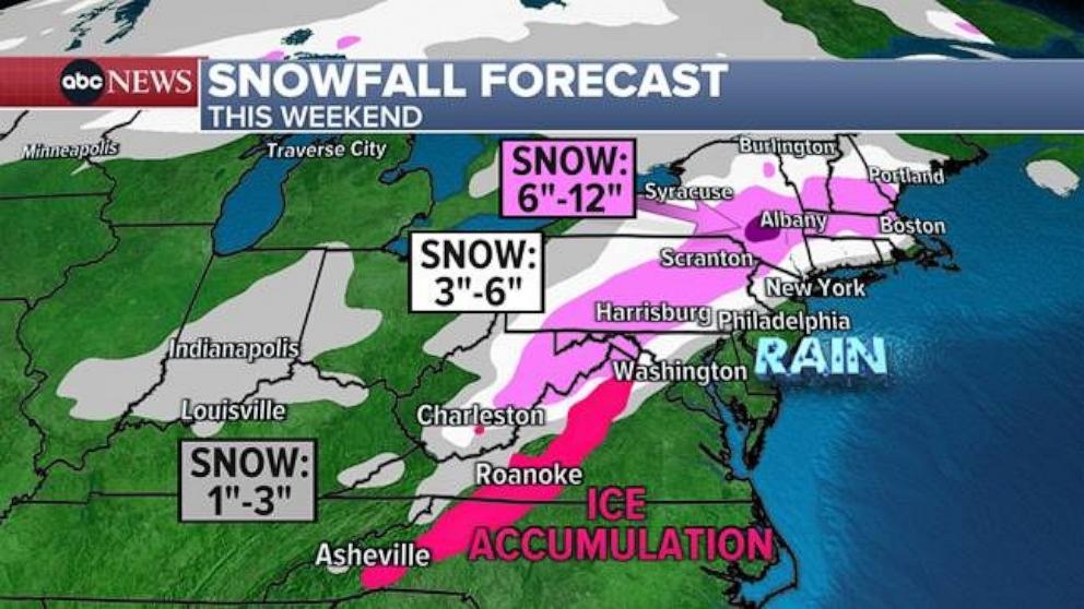
Mid-Jan looking (for now) like snowmageddon for Western Europe and UK.
California got 1-2ft yesterday.
West of Boston and NY, up to Maine, will see 6-12in this weekend.
Well, the person's real but it's just a made up name, see?
Well, the person's real but it's just a made up name, see?
Too many trolls/unappreciative people for him in the end, I think. Sadly.
######
God damn trolls if that is the reason he's no longer posting here.
What a loss. Noza was a legend, and an absolute fountain of knowledge on all things meteorological & alpine weather related around here. I'm actually upset to hear this tbh.
I normally dip in here about 4 weeks before any trip and I have been doing so now for ~nigh on 20 years when I decided to move my ski level from seasoned jock p@ss head, to more dedicated powder hound. Noza & a few of the more informed weather posters here have not just enhanced my trips by giving the best likely outlines for the next 3-5 days , but they've also decided me on where to go at short notice to seek optimal conditions. I've regularly pm'd him at season end to thank him (as I will now 1 last time with this post) & promised to buy him multiple beers or dinner if I ever had the privilege to meet him.
Whatever happened here to lose the likes of Noza needs to be addressed imho, as he was a diamond in the snow !!!


 Poster: A snowHead