Having said that, (80s change), I first went skiing with school in 1970 in Seefeld. We had to be minibussed up the mountain to find snow, as none on the lower slopes. It was late March, but still! Snow cover has always seemed better since then
Obviously A snowHead isn't a real person
Obviously A snowHead isn't a real person
Periods of mild weather in winter were not invented during the 80s by a grinning stockbroker driving a Sinclair C5 blasting out Alive and Kicking on his Sony Walkman.
The 1928 Olympics in St Moritz saw temperatures reaching 25C in February and lead to the cancelling of the 10k speed skating.
In 1932 in Lake Placid there was almost no snow and for two months before the event and instead they suffered from mild temperatures and rain.
“Lake Placid was faced with the worst winter weather in the history of the United States Weather Bureau.
Snow was trucked in daily from as far away as Maine so the ski events could be held, and poor weather forced the four-man bobsled event to be held after the closing ceremony.”
Roll forward to the infamous games of 1936 in Garmisch. There was so little snow in January that there were concerns the games would have to be cancelled. The snow only arrived on 05/06 February.
Well, the person's real but it's just a made up name, see?
Well, the person's real but it's just a made up name, see?
@Peter S, Not so sure about that. I started skiing in the mid 80s and remember years with little or no snow at Christmas / New Year. I suspect if you go back a good deal further, say immediate post war period, things were much colder and winter started earlier than now. Speaking to older folk around Munich they all can remember regular daytime temperatures down to -20 or less, now we sometimes get the occasional night with those sort of temperatures, though extended periods of temperature below zero are not unusual. There will always be "unusual" variations in temperate or weather, as noted above there would have been unusually warm periods too.
GFS 06z toying with temperatures 16C below average for the time of year in FI. Good support from control as well.
Innsbruck
Anyway, snowHeads is much more fun if you do.
Anyway, snowHeads is much more fun if you do.
@nozawaonsen, clearly those graphs didn't have enough squiggly lines, so they've added in the GFS Parallel yellow tramline....can see it's also below the mean. Some incredible charts out there as the models pick up various blocking signals for the 2nd week of Dec, but are not sure where to put it....scandi, or regressing towards iceland / greenland, or even getting flattened into europe by an artic front.
Looking at next weekend though, nice to see GFS correct the jet stream further west, more in line with ECM / GEM / UKMO (heavier snowfall). Also thursday is sneaking in some earlier snow to 1800/1900m.
Judging from webcams, the thin snowpack here in PdS at 1600-2300 seems to be holding up so far after 8 hours of heavy rain.
Just had a read through this and it looks like next week could see a much needed improvement in conditions, does Zell am See look like it'll be joining the fun and catching some snow? Also just to make myself look like an even bigger amatuer, is Zell am See classed as the western alps?
You'll get to see more forums and be part of the best ski club on the net.
You'll get to see more forums and be part of the best ski club on the net.
@notverygoodatskiing, no it’s on the eastern side of the Alps and yes at present it looks like it should get a fair amount of fresh snow from next weekend.
Ski the Net with snowHeads
Ski the Net with snowHeads
Super news, I'll sit back and watch this thread every 5 mins and now I know it's eastern I won't make myself look silly again
snowHeads are a friendly bunch.
snowHeads are a friendly bunch.
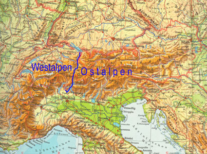
@notverygoodatskiing, it’s a bit confusing if you don’t know the geography. This might help.
nozawaonsen wrote:
Struggling up from the archives... This from a few years ago. Click on the HISTALP link. It's the northern side and southern side that is the important part.
nozawaonsen wrote:
@Gaza, and here's some more from the archives... The HISTALP link is good for north versus south.
Quote:
mheadbee, the Portes du Soleil are in the north and the west.
See this from last year. Linking to the year before. Few of the resorts have crossed from one side of the Alps to the other in the intervening period.
nozawaonsen wrote:
In terms of the geography of the Alps have a look at this from last year (click on the HISTALP link).
nozawaonsen wrote:
HISTALP has a useful map, but I tend to think of the Eastern Alps as roughly east of a line between Lake Constance (Bodensee) and Lake Como (so further west than it appears on the HISTALP map).
And love to help out and answer questions and of course, read each other's snow reports.
And love to help out and answer questions and of course, read each other's snow reports.
Like they say, every little helps haha, I'll be driving to resort in a motorhome so I'm watching it closely, as much as I want a massive dump of snow I could do with it happening either before or just after we arrive, just not on the drive up. Worse case scenario we can pull up for a while and crack a beer or 2 open so it won't be the end of the world.
So if you're just off somewhere snowy come back and post a snow report of your own and we'll all love you very much
So if you're just off somewhere snowy come back and post a snow report of your own and we'll all love you very much
@notverygoodatskiing,
Bergfex is a pretty good site. As well as the weather, there are webcams, piste maps and other useful info.
Great, another one to put on the list for obsessive webcam/weather checking
Otherwise you'll just go on seeing the one name:
Otherwise you'll just go on seeing the one name:
notverygoodatskiing wrote:
Great, another one to put on the list for obsessive webcam/weather checking
AFAIK Bergfex's specialty is all things Austria.
Poster: A snowHead
Poster: A snowHead
nozawaonsen wrote:
@notverygoodatskiing, no it’s on the eastern side of the Alps and yes at present it looks like it should get a fair amount of fresh snow from next weekend.
A long way Ost as well... It's not even in the Tirol I believe but just in Salzburgerland. I think it's above the "n" and a bit to the right in noza's map.
A very attractive setting, especially if the lake freezes. Skiing a little limited. Be great when the Saalbach link is finished
Obviously A snowHead isn't a real person
Obviously A snowHead isn't a real person
notverygoodatskiing wrote:
Great, another one to put on the list for obsessive webcam/weather checking
+1!
Well, the person's real but it's just a made up name, see?
Well, the person's real but it's just a made up name, see?
Sorry if it has been asked before, but what is the "parallele" line?
@buchanan101, cheers, it's more of a family winter holiday than 2 weeks hardcore snowboarding so the limited slopes are fine, If I can get a few days playtime in that'll be a bonus. I'm weather watching mainly for the driving to be honest but I know a lot can change, ideally it'll snow for a couple of weeks and the roads would of been cleared by the time we arrive, then it can snow for another couple of weeks once we're parked up haha
Anyway, snowHeads is much more fun if you do.
Anyway, snowHeads is much more fun if you do.
notverygoodatskiing wrote:
@buchanan101, cheers, it's more of a family winter holiday than 2 weeks hardcore snowboarding so the limited slopes are fine, If I can get a few days playtime in that'll be a bonus. I'm weather watching mainly for the driving to be honest but I know a lot can change, ideally it'll snow for a couple of weeks and the roads would of been cleared by the time we arrive, then it can snow for another couple of weeks once we're parked up haha
The roads to Zell _should_ be fine (save a large dump). It's low and the roads are good.
A long way Ost as well... It's not even in the Tirol I believe but just in Salzburgerland. I think it's above the "n" and a bit to the right in noza's map.
[/quote]
Without being too picky, think you will find Zell (and Saalbach) are in the Tyrol
Then you can post your own questions or snow reports...
Then you can post your own questions or snow reports...
Nope, Zell is in Salzburgerland - just. Saalbach is too it seems, but Fieberbrunn is Tyrol. One of the ski loops in Saalbach claims to cross the border
Last edited by Then you can post your own questions or snow reports... on Mon 3-12-18 17:41; edited 1 time in total
After all it is free
After all it is free
@leggyblonde, it's the new version of GFS, also called FV3. The switch will take place in Jan 19, but for now it's just run in 'parrallel' to the existing model.
Some technical blurb from NOAA below, but it has been performing well over the last 6 months, sometimes topping even the ECM in the 10 day range.
Apart from being built differently, my understanding is it will run at a higher resolution, and out to 16 days, whereas the current GFS model goes into lower resolution after day 10.
A lot of flaws with the old GFS, and I'm hoping that today's 12z is an example, as it wants to steamroll the atlantic systems thru the HP block trying to build early next week (t+180). If this run verifies then temps will be a lot higher next week than modelled so far (closer to 0 than -12). But GFS has a well known bias for over amplifying troughs and not handling blocking very well. So will keep an eye on UKMO (which is good today at t+144), and ECM later. Also the FV3 which rolls out about an hour after the GFS, hopefully the others won't be so bad, and the GFS 12z Op ends up being an outlier rather than the start of a new trend.
You'll get to see more forums and be part of the best ski club on the net.
You'll get to see more forums and be part of the best ski club on the net.
@polo, thanks as always!
And fingers crossed
Ski the Net with snowHeads
Ski the Net with snowHeads
Cardrona, in New Zealand, reopened temporarily this weekend, due to fresh snow.
snowHeads are a friendly bunch.
snowHeads are a friendly bunch.
Whitegold wrote:
Cardrona, in New Zealand, reopened temporarily this weekend, due to fresh snow.
It’s not unusual for the South Island of NZ to get late snow. A few years ago Christchurch (at sea level) got 30cm on Christmas Day!!! The cold fronts that roll through are sometimes crackers!
And love to help out and answer questions and of course, read each other's snow reports.
And love to help out and answer questions and of course, read each other's snow reports.
Quote:
Without being too picky, think you will find Zell (and Saalbach) are in the Tyrol
@PeterGee, I can confirm that we (fortunately, as the Tyrol is more restrictive on buying property) and also Zell am See are in Salzburgerland. The TirolS gondola, which connects Saalbach-Hinterglemm with Fieberbrunn spans the border, but we don't need passports
So if you're just off somewhere snowy come back and post a snow report of your own and we'll all love you very much
So if you're just off somewhere snowy come back and post a snow report of your own and we'll all love you very much
sbooker wrote:
Whitegold wrote:
Cardrona, in New Zealand, reopened temporarily this weekend, due to fresh snow.
It’s not unusual for the South Island of NZ to get late snow. A few years ago Christchurch (at sea level) got 30cm on Christmas Day!!! The cold fronts that roll through are sometimes crackers!
It's been the most f******d up summer for years here. Due for more snow this week above 1000m. Mt Hutt sitting on a 2 metre base, never got over 1 metre all winter, and has had about 3 metres of snow since it closed.
Haven't even managed to get a fishing rod out yet this year due to wind/rain/snow pretty much every day in the high country for weeks.
You know it makes sense.
You know it makes sense.
Very heavy rain in France and Switzerland today.
But snow on the way.
Austria and France will get battered in the next 5-10 days.
Expect 100-200cm in Lech, Les Arcs, Chamonix, etc.
Otherwise you'll just go on seeing the one name:
Otherwise you'll just go on seeing the one name:
Extract from SLF
At elevated altitudes a high avalanche danger will be encountered in some regions
Fresh snow
From the start of the precipitation on Saturday evening until Monday afternoon, the following amounts of snow fell above approximately 2500 m:
- Valais, northern Alpine ridge, northern Grisons, northern Lower Engadine: 20 to 40 cm, but locally as much as 60 cm in the extreme west of Lower Valais and in northern Valais
- Elsewhere: 10 to 20 cm, but remaining largely dry in central and southern Ticino, and in Val Bregaglia and Val Poschiavo.
Weather forecast through Tuesday, 04.12.2018
On Monday night the precipitation will become heavier in the west and north. During the day it will be mostly very cloudy, and further precipitation will fall in the east in particular. The snowfall level will drop during the night to approximately 1400 m. To the south of the central part of the main Alpine ridge it will remain dry and, as a consequence of the freshening northerly wind, it will be mostly sunny.
Fresh snow
From Monday afternoon until Tuesday afternoon the following amounts of snow will fall above approximately 2300 m:
- Northern flank of the Alps from the eastern Bernese Alps to the St Gallen Oberland, extreme west of Lower Valais: 40 to 60 cm
- Rest of the northern flank of the Alps, rest of Valais, northern Grisons, northern Lower Engadine: 20 to 40 cm
- Central Grisons, rest of Engadine, Val Müstair: 5 to 20 cm
Elsewhere: a few centimetres or remaining dry
Outlook through Thursday, 06.12.2018
Wednesday
The north will be mostly cloudy with sunny spells. It will be fairly sunny in the south. The avalanche danger will decrease.
Thursday
As a consequence of the westerly wind, the west and north will be frequently cloudy, and precipitation will fall at times. The snowfall level will be approximately 2000 m. The south will be partly sunny. The avalanche danger will increase in the west and the north in some regions.
Poster: A snowHead
Poster: A snowHead
Met Office contingency planners suggesting increased likelihood of -NAO this winter and increasing likelihood of below average temperatures as winter progresses.
“A moderate El Niño event is expected this winter. This increases the likelihood of the negative phase of the North Atlantic Oscillation (NAO) in late winter, implying an increased chance of colder-than- average conditions.
The stratospheric polar vortex is currently stronger than is normal at this point in autumn, but is predicted to become weaker than normal later in winter. Events in the stratosphere can subsequently influence surface weather, resulting in increased chances of mild conditions in December but colder conditions later on. Further, the sun is approaching a minimum in its 11-year cycle of activity, which also increases the likelihood of a weak stratospheric circulation and cold weather later in the winter.
The Quasi-Biennial Oscillation (QBO), an oscillation of the equatorial winds in the stratosphere, will be in its westerly phase this winter. This phase tends to increase the likelihood of a positive phase of the NAO and milder-than-average conditions.
North Atlantic sea surface temperatures (SSTs) continue to show a pattern of colder-than-average conditions south of 30°N and north of 50°N, with warmer-than-average conditions in a band in between. This pattern of SST anomalies moderately increases the chances of a positive phase of the NAO and milder-than-average conditions in early winter.
For December-January-February, long-range prediction systems, including the Met Office system, show a moderate increase in the likelihood of negative NAO overall. For the winter as a whole, therefore, there is a modest increase in the probability of colder-than- normal temperatures (see figure T2).
Nevertheless, signals for negative NAO increase during the winter, implying that the chances of cold weather related impacts, such as snow, are highest in the later part of the outlook period.”
Austria and France will get battered in the next 5-10 days.
Expect 100-200cm in Lech, Les Arcs, Chamonix, etc.
every weather report this week has been hinting at that.
There was also supposed to be snow last weekend. Every webcam shows it didnt happen.
So not getting my hopes up!
Well, the person's real but it's just a made up name, see?
Well, the person's real but it's just a made up name, see?
It snowed heavily at altitude at the weekend as forecast in parts of Switzerland, Italy and France.
Temperatures will fall next weekend and there will be further snowfall to low levels. Snowfall in the Arlberg looks like it could be substantial.
It snowed heavily at altitude at the weekend as forecast in parts of Switzerland, Italy and France.
Temperatures will fall next weekend and there will be further snowfall to low levels. Snowfall in the Arlberg looks like it could be substantial.
lot can happen in the next 3 days.
Off to Innsbruck on Sunday & still have no idea which resort I will at on Monday!
All the reports for the last 7-10 days have been wrong by a fair margin. Certainly not the 10cm+ on some days predicted. All the trees still green!
Anyway, snowHeads is much more fun if you do.
Anyway, snowHeads is much more fun if you do.
The forecasts were for heavy snow above 2000m in parts of the western Alps. It snowed heavily in these areas above 2000m.
Then you can post your own questions or snow reports...
Then you can post your own questions or snow reports...
nozawaonsen wrote:
The forecasts were for heavy snow above 2000m in parts of the western Alps. It snowed heavily in these areas above 2000m.
like I said
the ones I was checking had no such thing!
After all it is free
After all it is free
Mr.Egg wrote:
All the reports for the last 7-10 days have been wrong by a fair margin.
what forecasts were you looking at?
Posts on this thread have been spot on the last 7-10 days, models predicted rain to high levels, and they have been very accurate from what I can see. No reason at all to think the coming weekend won't be as accurate.
ECM and GFS both penciling in up to 100cm for northern flank to low levels sat-mon, again been consistently modelled from 7-8 days out.
Rest of next week is still largely FI, with most output pointing at a ridge up towards Iceland, leaving alps in a cool and drier easterly, so not bad. And increasing chances of a rare Dec SSW unfolding, which would likely lead to a cold Jan if it comes off.
You'll get to see more forums and be part of the best ski club on the net.
You'll get to see more forums and be part of the best ski club on the net.


 Poster: A snowHead