Poster: A snowHead
|
|
|
|
Obviously A snowHead isn't a real person
Obviously A snowHead isn't a real person
|
|
Ignorance here, what does the NAO Index mean and what is the graph telling us?
|
|

|
|
|
|
Well, the person's real but it's just a made up name, see?
Well, the person's real but it's just a made up name, see?
|
|
|
|
You need to Login to know who's really who.
You need to Login to know who's really who.
|
@FrediKanoute, an explanation from 2012.
“Hi mooney058, the NAO is the North Atlantic Oscillation. In general you have a high pressure system near the Azores and a low pressure system near Iceland. However, their strength and position varies and this can have a big impact on the weather in Europe (and indeed on the other side of the Atlantic) not least because it can influence the position of the jet stream.* The NAO index is derived from measuring the relative pressure over Iceland and Gibralter.
A +NAO typically sees warm and wet westerly winds push across the Atlantic into northern Europe. This means the weather in Northern Europe is often stormy and milder than usual. In southern Europe the strength of the Azores high means less wet weather and cooler than usual temperatures. This can translate in the Alps into more precipitation on the northern side of the Alps. This was very much in evidence in December 2011 and January 2012 when a series of storms brought large amounts of snow to the northern Alps, but it often did not reach the southern Alps.
A -NAO allows cooler weather to push down into northern Europe although often this can be drier. Conversely with the jet stream pushing south wetter and warmer weather tends to effect southern Europe. In the Alps this can mean more snow in the southern Alps. December 2010 (and 2009) was notable for a very - NAO and brought very cold weather to much of northern Europe.
That said as a predictive tool it is very broad brush as the exact weather patterns on the day will define the weather rather than the general trend.”
|
|
|
|
|
|
Anyway, snowHeads is much more fun if you do.
Anyway, snowHeads is much more fun if you do.
|
Big wave of moisture is knocking on the door of the West Coast. From North Cali all the way up British Columbia way. Will come in on the warm side, but there's a nice cold bit spinning down from the Aleutian Islands that will help cool things off as it makes landfall some time around Tuesday into Wednesday. That storm will be followed by a second wave of cool air, again spinning down from Gulf of Alaska. Storms should have enough energy and moisture to spread the love all the way into Utah, Wyoming, Idaho and Colorado. Will be interesting to see what the total accumulation will be. Predictions from the local PNW weather folks is about 40cm-60cm for the Cascades. Similar numbers being bandied about for Whistler. Interior areas of Utah and Colorado are hedging their bets, but could be 25cm-40cm depending on the usual caveats of wind directions and temps. Fingers are crossed and hoping that Old Man Winter delivers some early stocking stuffers! 
|
|
|
|
|
|
You'll need to Register first of course.
You'll need to Register first of course.
|
12z GFS once again throws out a very blocked outlook for FI.

This would be a very cold outlook. Obviously though it needs to start coming into the nearer term before it can be taken seriously. Still interesting that it keeps cropping up...
|
|
|
|
|
|
|
|
Matt Hugo.
“Trend can be a friend, as the saying goes in the weather world. I've been mentioning the possibilty of a return to a more amplified/high pressure pattern for days and the 12Z GFS does it with some success. We're not looking for details, just a continued trend for this pattern...”
https://twitter.com/matthugo81/status/1067098731001057280?s=21
|
|
|
|
|
|
|
|
And 18z GFS ends up with this...

More blocking and more cold over the Alps.
|
|
|
|
|
|
You'll get to see more forums and be part of the best ski club on the net.
You'll get to see more forums and be part of the best ski club on the net.
|
|
Are we saying these scenarios are cold & dry...or cold & potentially snowy?
|
|
|
|
|
|
|
|
|
|
|
snowHeads are a friendly bunch.
snowHeads are a friendly bunch.
|
@luigi, how long is a piece of string  ....that GFS 18z graph above would certainly be snowy in the east, dry and warmer west. But any hints of decent blocking are 10-12 days away, and even if we do get high pressure again over Scandinavia, will it be far enough north to draw snowy conditions towards the alps (ideally a cut off high), otherwise europe stays dry and mild under the block. Anyway too many if's, and I'd rather see high's out in the atlantic towards greenland. ....that GFS 18z graph above would certainly be snowy in the east, dry and warmer west. But any hints of decent blocking are 10-12 days away, and even if we do get high pressure again over Scandinavia, will it be far enough north to draw snowy conditions towards the alps (ideally a cut off high), otherwise europe stays dry and mild under the block. Anyway too many if's, and I'd rather see high's out in the atlantic towards greenland.
Matt Hugo certainly isn't alone.....I don't think I've read a forecaster not predicting high lattitude blocking in december . Background signals are solar min, summer analogs, -AO period, MJO phase 8-1, AAM rising, disorganised trop vortex and a strat vortex also under pressure from warming event and lower zonal winds. Most comments I've read tend to mention second week of Dec as the most likely.
But no real sign of it yet on the models. Apart from occasional FI charts, the EC46 model 4 week outlook shows europe mostly under high pressure (like many recent decembers).
http://brunnur.vedur.is/kort/ec-ens/2018/11/26/00/ec-ens_nat_taem_gh500_anom.htm
And in the nearer term, it looks likely we'll get a brief warm and wet spell next week.....both ECM and GFS stay zonal on the 00z....(altho GFS Op and control runs were warm outliers). Still lots of uncertainty for first week of Dec.
So get out there and make the most of it if you can.....most places have had a good dump last night, and it's still snowing in PdS....so am outta here
|
|
|
|
|
|
And love to help out and answer questions and of course, read each other's snow reports.
And love to help out and answer questions and of course, read each other's snow reports.
|
I know we shouldn't trust anything further than 3 days out but is this a promising potential diversion for the jet stream? (9th to 12th Dec) You can see that Southern Fohn coming in a few days time and there seems to be a lot of switching N and S wise. That Northerly "Jetstream Violence" (To quote Morris of Wepowder) looks as if it could light up the Northside of the Alps.
https://www.netweather.tv/charts-and-data/jetstream

|
|
|
|
|
|
|
|
| clarky999 wrote: |
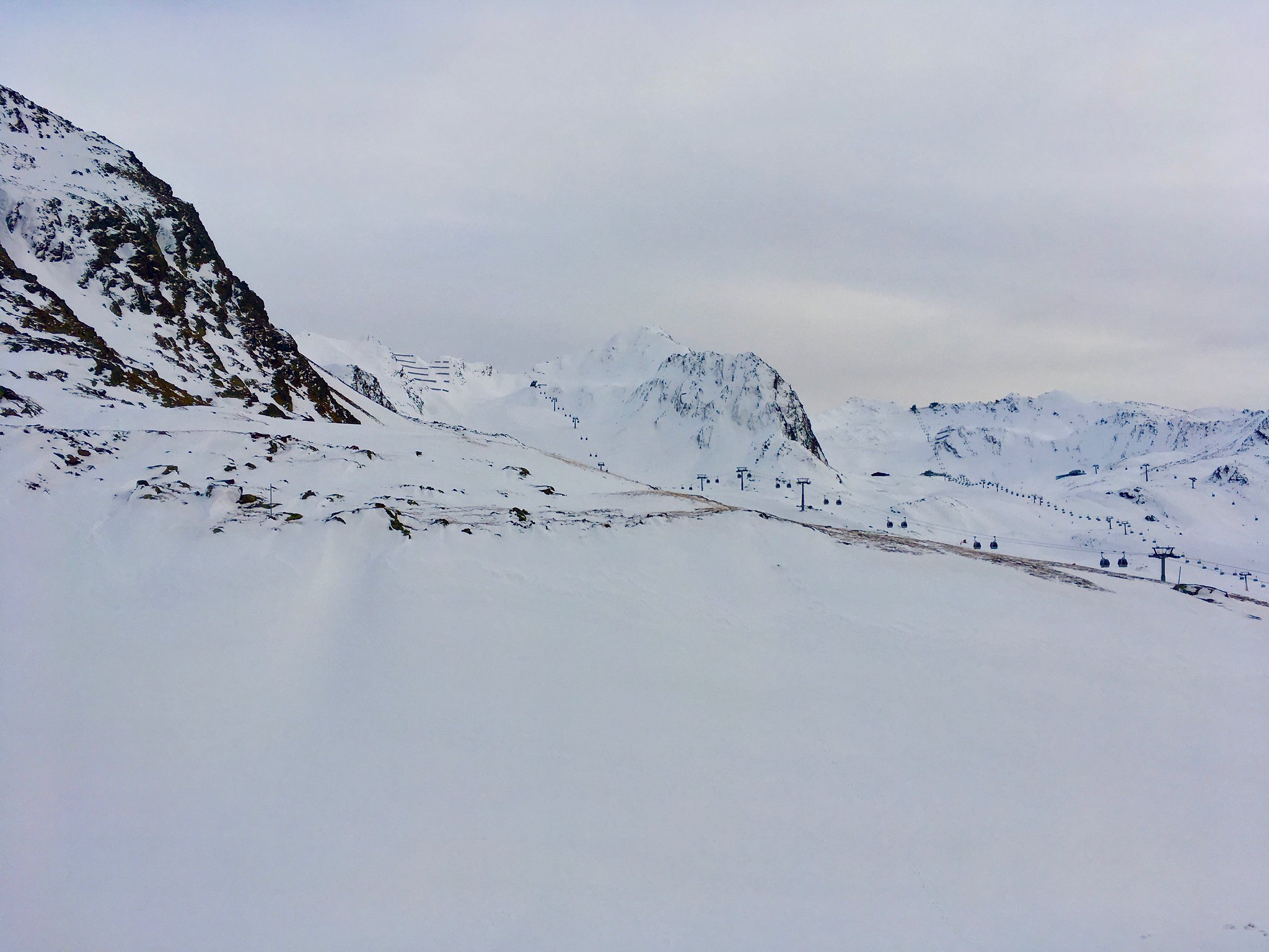
Some surprisingly decent snow in Obergurgl today - can even ski down to the valley on the Hochgurgl end. Below Hochgurgl village everything is pretty much artificial snow, but there's much more natural snow high up than I expected. Even some nice offpiste lines are in play, though you have to be pretty choosy and watch out for sharks. Crappy phone pictures through the gondola windows, but you get the picture hopefully:
I figure Stubai and Sölden must be in similar condition (Sölden looked to have less snow on the lower mountain though). |
I see you are in the new lift extension - run from the top any good?
|
|
|
|
|
|
You know it makes sense.
|
| Quote: |
| How is Obergurgl? Looking to go to Hochgurgl in Mid December, any chance for long queues? |
Obergurgl? Queues? Never more than a minute or two.
|
|
|
|
|
|
Otherwise you'll just go on seeing the one name:
Otherwise you'll just go on seeing the one name:
|
Mariazell looking very festive.

|
|
|
|
|
|
Poster: A snowHead
|
| buchanan101 wrote: |
| clarky999 wrote: |
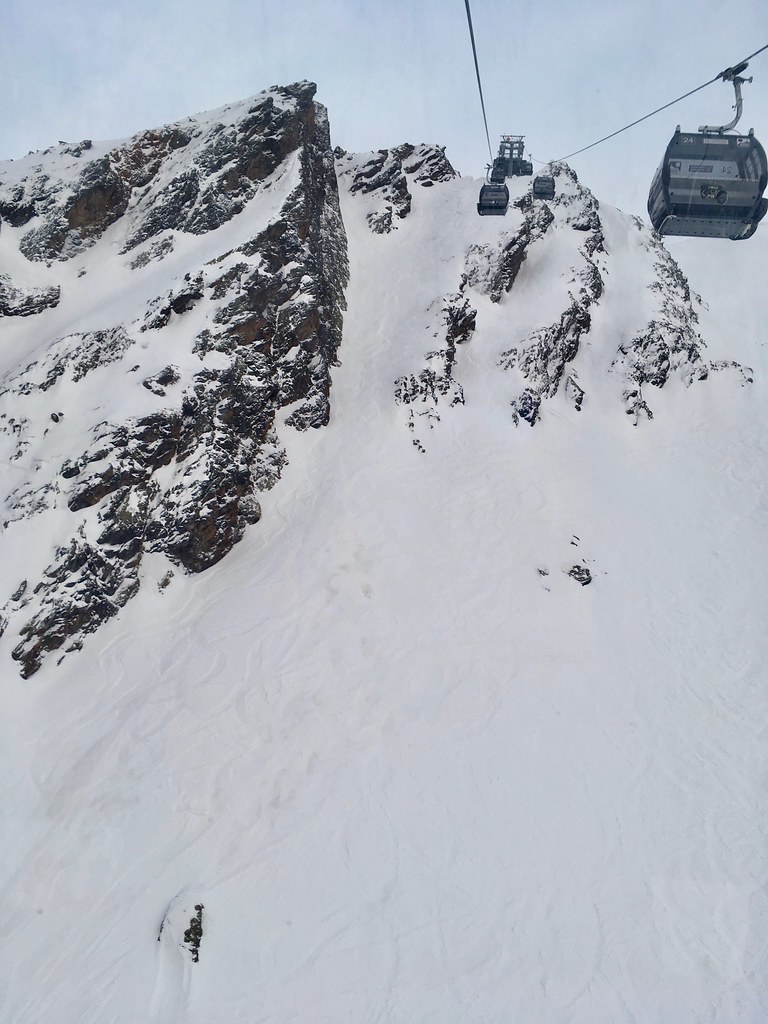
Some surprisingly decent snow in Obergurgl today - can even ski down to the valley on the Hochgurgl end. Below Hochgurgl village everything is pretty much artificial snow, but there's much more natural snow high up than I expected. Even some nice offpiste lines are in play, though you have to be pretty choosy and watch out for sharks. Crappy phone pictures through the gondola windows, but you get the picture hopefully:
I figure Stubai and Sölden must be in similar condition (Sölden looked to have less snow on the lower mountain though). |
I see you are in the new lift extension - run from the top any good? |
Oh, is that new? Hadn't clocked that haha. Yeah was nice! We skied right under the gondola; didn't actually notice a piste on that side, but that was the very last lift up so we were in a bit of a rush.
| südtirolistdeutsch wrote: |
How is Obergurgl? Looking to go to Hochgurgl in Mid December, any chance for long queues? |
Snow definitely better on the Hochgurgl side, and no skiing to the valley on the Obergurgl side yet, but still a lot better than most probably imagine given the weather lately. Not sure about queues in Dec, sorry - I normally only ski there in November and May when the more local resorts aren't open.
|
|
|
|
|
|
Obviously A snowHead isn't a real person
Obviously A snowHead isn't a real person
|
Bulgaria and Romania getting their first proper snowfall this week through Thursday.
Will set a base up high for Dec.
Vermont, US, due a foot of fresh this week. Stowe, etc.
Buffalo, near NY, due 2 feet (~50cm)
|
|
|
|
|
|
Well, the person's real but it's just a made up name, see?
Well, the person's real but it's just a made up name, see?
|
Currently looks like bit of a North South split coming up over the next six days.
Where Southern Alps scored last week, as has been mentioned turn of the Northern Alps and again Courmayer / Entreves, South of Chamonix will do well.
We travel down Fri for a limited weekend opening but looks like rain in the valley but no complaints.
At least the very cold temps this week are helping to keep the snow.
|
|
|
|
|
|
You need to Login to know who's really who.
You need to Login to know who's really who.
|
Yes, Les Arcs (where I’ll be in a few weeks) looks like it’s in a good position.
Only complaint is that it looks like the bulk of it will only happen above 2100m. Hopefully they get that wrong and it slips down a few hundred metres.
|
|
|
|
|
|
Anyway, snowHeads is much more fun if you do.
Anyway, snowHeads is much more fun if you do.
|
|
CO will see some decent snow coming this weekend. Telluride, Crested Butte, Durango should all see at least a foot of fresh. Aspen could do okay with this storm coming via California. Southern Utah will also see snow. The snow is already falling in Tahoe ski areas, and they could see about a foot of snow by end of Thursday.
|
|
|
|
|
|
You'll need to Register first of course.
You'll need to Register first of course.
|
|
Any updates from the weather gurus regarding the possibility of some flakes in Tirol before Christmas?
|
|
|
|
|
|
|
|
| sbooker wrote: |
| Any updates from the weather gurus regarding the possibility of some flakes in Tirol before Christmas? |
Looking like there's more than a few flakes there already on the cams. They're also pumping it out of the snow cannons onto the meadows like billy-oh too. 
Söll/SkiWelt webcams: https://www.bergfex.com/soell/webcams/c1962/
Just hope the nasty hairdryer doesn't come over from Italy and take it all away!!
|
|
|
|
|
|
|
|
|
|
|
You'll get to see more forums and be part of the best ski club on the net.
You'll get to see more forums and be part of the best ski club on the net.
|
|
|
|
|
|
|
|
|
snowHeads are a friendly bunch.
snowHeads are a friendly bunch.
|
|
We're seeing friends in Bozel near Courchevel and tagging on a few days skiiing 17th-19th Dec. Looks like altitude might be needed for some half decent conditions. We've skiied Val Thorens a fair bit but never Tignes or Val D'Isere - any thoughts on which of the three might have the better snow?
|
|
|
|
|
|
And love to help out and answer questions and of course, read each other's snow reports.
And love to help out and answer questions and of course, read each other's snow reports.
|
|
@Barbs007, I'd decide on the 16th personally! Lots can and probably will chance by then.
|
|
|
|
|
|
|
|
|
At this stage of the season, where some places have X amount of pistes open, what’s the likelihood of that number going down if the temperatures and freezing level go up next week? Is it a case of what we have we hold at a minimum by this stage of the season and things can only get better? Flights booked for weekend of 13th Dec. usually don’t travel this early in the season and would love to lock something in while some prices are still reasonable.
|
|
|
|
|
|
You know it makes sense.
|
| Quote: |
At this stage of the season, where some places have X amount of pistes open, what’s the likelihood of that number going down if the temperatures and freezing level go up next week?
|
Pretty high likelihood of reduction apart from perhaps at the highest resorts IME
|
|
|
|
|
|
Otherwise you'll just go on seeing the one name:
Otherwise you'll just go on seeing the one name:
|
The Sierra's are going to get a direct hit of moisture and cold temps = over a meter of snow at higher elevations. The storm is looking to track a bit South of the Wasatch, but they will still get some scraps. Enough moisture and cold temps flowing up into Southern Oregon, will give Bachelor some much needed love as well.
https://imgur.com/a/Db7MfKh
|
|
|
|
|
|
Poster: A snowHead
|
| Quote: |
Quote:
At this stage of the season, where some places have X amount of pistes open, what’s the likelihood of that number going down if the temperatures and freezing level go up next week?
Pretty high likelihood of reduction apart from perhaps at the highest resorts IME
|
I’d disagree, the only pistes open in Europe at the moment are pretty high, will be fairly compacted, and a have a fairly high percentage of manmade snow. These three factors should prevent significant snow loss from the pistes themselves although they will become pretty soggy in the short term. Off piste areas surrounding them are likely to turn green again though
|
|
|
|
|
|
Obviously A snowHead isn't a real person
Obviously A snowHead isn't a real person
|
| Redial wrote: |
| At this stage of the season, where some places have X amount of pistes open, what’s the likelihood of that number going down if the temperatures and freezing level go up next week? Is it a case of what we have we hold at a minimum by this stage of the season and things can only get better? Flights booked for weekend of 13th Dec. usually don’t travel this early in the season and would love to lock something in while some prices are still reasonable. |
I agree with rambotion - as long as the pistes have artificial, compacted snow I think most of them will stay open, even though the uncompacted, natural snow on the surrounding hillsides may take a big hit. The one thing that may change this is warm and heavy rain (warm sunshine isn't such an issue, especially if humidity is low). That currently only looks possible in the far northern Alps.
|
|
|
|
|
|
Well, the person's real but it's just a made up name, see?
Well, the person's real but it's just a made up name, see?
|
|
You're also not taking in to account the unknown. Some models are predicting a return to cold towards the end of next week and a lot of snow. So things could improve after a dip in the coming days. Obviously that's FI but the point is it is unknown and speculating about the state of pistes in 2 weeks' time is FI too. Not to mention we don't know where the flights are to - pretty big difference North Vs South of the Alps at the moment.
|
|
|
|
|
|
You need to Login to know who's really who.
You need to Login to know who's really who.
|
|
@nemesys, Agreed, I wouldn't be booking anything for another 10 days!
|
|
|
|
|
|
Anyway, snowHeads is much more fun if you do.
Anyway, snowHeads is much more fun if you do.
|
The storm for the 9th is starting to crop up on various weather vehicles. There has been a distinct change in the West of England where Atlantic storms have started to form a queue and bring severe weather. The jet stream has moved south. Tignes is a banker. We went storm chasing last year on the 14th December for a 3 day hit and run. Arriving at Peissey as powder alert 8 was materialising. We had to go to Val D'Isere the first day as Paradiski would not open early despite the stellar start to pre season. The next three days were awesome. Much more snow that predicted and this is the best bit ===> No-one around. I did 45 km and only rode 4 pistes. The Peissey tree runs at their best. It was one of the best trips I have ever had and that was because it was bespoke for the conditions. Leave the flight until 4 days out then decide. 
|
|
|
|
|
|
You'll need to Register first of course.
You'll need to Register first of course.
|
|
|
|
|
|
That looks like a pretty damn good chart for opening week in Verbier. POWDER!!!
|
|
|
|
|
|
|
|
|
|
|
You'll get to see more forums and be part of the best ski club on the net.
You'll get to see more forums and be part of the best ski club on the net.
|
|
@südtirolistdeutsch, roughly.
|
|
|
|
|
|
|
|
| Quote: |
The Arlberg

|
So the way I would read that, if I had a meeting finishing in Munich on the 5th of December, there may be good conditions somewhere in Austria a few hours drive away after it ends?
I ask, 'cos if I was to sell it to my workmates I would want to know I was reading it right.
|
|
|
|
|
|
|
|