Poster: A snowHead
|
|
|
|
Obviously A snowHead isn't a real person
Obviously A snowHead isn't a real person
|
|
|
|
Well, the person's real but it's just a made up name, see?
Well, the person's real but it's just a made up name, see?
|
Interesting read, thanks. Is there a glossary somewhere for all those acronyms?
|
|

|
|
|
|
You need to Login to know who's really who.
You need to Login to know who's really who.
|
|
Snowline is around 1500 meters in the French alps this PM (bit lower in the north) but not a lot of depth as yet. Maybe 10cm at 2000m?
|
|
|
|
|
|
Anyway, snowHeads is much more fun if you do.
Anyway, snowHeads is much more fun if you do.
|
SLF update for Swiss Alps.
“Weather review to Saturday, 27 October
On Saturday, skies were predominantly overcast and there was precipitation over widespread areas, in southern regions quite heavy in some places. The snowfall level in southern regions was at 2400 m, in northern regions between 1200 and 1800 m. The southerly winds were blowing at light to moderate strength, in southern regions at moderate to strong velocity during the course of the day.
Between Friday evening and Saturday evening, the following amounts of fresh snow were registered, in southern regions above approximately 2800 m, in northern regions above approximately 2400 m, in the furthermost western regions above approximately 2000 m:
- Central and eastern sectors of the Main Alpine Ridge, Val Poschiavo: 20 to 40 cm;
- in the Bernina region as much as 60 cm;
- Northern Alpine Ridge, western Lower Valais, northern flank of the Alps west of Lake Thun, remaining parts of northern and central Grisons, as well as remaining parts of Engadine: 10 to 20 cm;
- remaining sectors of the northern flank of the Alps, remaining parts of the Valais: 5 to 10 cm.
Weather outlook through Sunday, 28 October
On Saturday night, precipitation is anticipated over widespread areas, in southern regions it will be heavy and intensive. During the daytime on Sunday, the precipitation will come to an end in northern regions. In western regions more than anywhere else, sunny intervals are anticipated. In southern regions the precipitation will slacken off somewhat. The snowfall level will vary starkly: during the night in northern regions it will lie at between 500 and 1000 m, on the Main Alpine Ridge and southwards therefrom it will lie at 2300 m; during the daytime it will rise swiftly to 2300 m from the southeast in all regions of Switzerland. The southerly winds will be blowing at moderate to strong velocity at high altitudes.
Between Saturday evening and Sunday evening, the following amounts of fresh snow are expected, in southern regions above approximately 2600 m, in northern regions above approximately 2300 m:
- Main Alpine Ridge from the Gotthard Pass into the Bernina Region, northern Ticino, Moesano, Val Poschiavo, Val Müstair: 60 to 90 cm; from Val Bregaglia into the Bernina region as much s 120 cm;
- Main Alpine Ridge from the Simplon region to the Gotthard Pass, remaining parts of central Grisons, remaining parts of Engadine: 40 to 60 cm;
- remaining parts of the western sector of the Main Alpine Ridge along the Italian border, Aletsch region, northern Grisons: 20 to 40 cm;
- in the remaining regions of Switzerland, 10 to 20 cm.
Outlook
On Monday, skies will be heavily overcast. Accompanied by storm-strength southeasterly winds, intensive precipitation is anticipated in southern regions, equally so in the Valais and the bordering Bernese and Central Swiss Alps. The snowfall level will lie at 2300 m, in the furthermost western regions the snowfall level will drop to intermediate altitudes during the course of the day. In the eastern sector of the northern flank of the Alps, skies will be intermittently bright as a result of foehn influence. On Monday night the snowfall will persist above approximately 1200 m, during the daytime on Tuesday the winds will slacken off over widespread areas. In southern regions, the skies will be overcast, in northern regions sunny intervals are possible as a result of foehn influence. As a consequence of strong-velocity southerly winds, wide-ranging snowdrift accumulations are expected to form.
The danger of dry-snow avalanches will continue to increase over widespread areas above approximately 2500 m, in some areas of the Valais on Monday, significantly so. In the major areas of precipitation at high altitudes, naturally triggered dry-snow avalanches can be expected. Furthermore, in those areas where there has been the greatest amounts of fresh snow, glide-snow avalanches and hillside sluffs can be expected to an increasing degree below approximately 2600 m.”
|
|
|
|
|
|
You'll need to Register first of course.
You'll need to Register first of course.
|
It's so nice to head outdoors and get battered by artic air and rain....coldest night since March, wettest day since May. I reckon at least 20cm has fallen to 1600m in the NW so far, and tomorrow morning should reveal a lower snowline. The ground is of course very warm and dry so the settled depth is going to be even lower than normal. Monday has warmed up, with FL above 2000, but dropping again into Tues morning. Precipitation wise the heaviest falls are due monday evening in NW as the med low sweeps due north.
The next big high pressure block is repeatedly setting up over eastern europe and up into scandinavia, so it's a battle as atlantic lows try to drop south into france. Nov 6-7 has popped up a few times showing this potential.
|
|
|
|
|
|
|
|
|
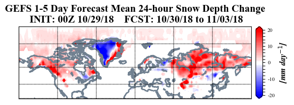
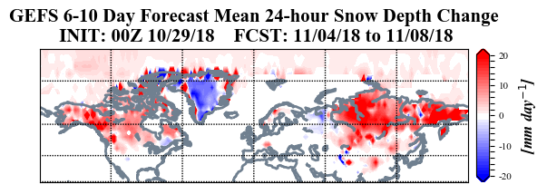
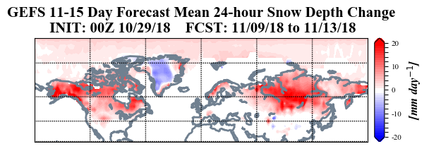
@polo, Yep period from the 05-08 November has seen heavy precipitation on last four GFS op runs particularly on the Swiss Italian border again. Be interesting to see if this has started to shape up into something over next couple of days or not.
|
|
|
|
|
|
|
|
@telford_mike thanks, I tried to search for one late last night, but couldn't find one.
I made this basic one a while back.
QBO is the Quasi Biennial Oscillation, which is a measure of stratospheric equatorial winds.
Basin-wide El Niño, means warm anomalies throughout the equatorial regions of the Pacific, except for the far West near Indonesia.
PDO is the Pacific Decadal Oscillation.
EPO is the Eastern Pacific Oscillation, that encompasses the region offshore of Alaska and Western Canada.
AO is the Arctic Oscillation, which is a big part of the Japanese outlook.
NAO is the North Atlantic Oscillation.
And the Aleutian Low is the low midway through the North Pacific, typically around the Bering Sea.
Scandi blocking, is in essence a high around Scandinavia, and Barents-Kara Sea blocking means a high North of Russia.
|
|
|
|
|
|
You'll get to see more forums and be part of the best ski club on the net.
You'll get to see more forums and be part of the best ski club on the net.
|
|
|
|
|
|
|
|
|
snowHeads are a friendly bunch.
snowHeads are a friendly bunch.
|
|
|
|
And love to help out and answer questions and of course, read each other's snow reports.
And love to help out and answer questions and of course, read each other's snow reports.
|
|
Currently dumping down in chamonix at town level!
|
|
|
|
|
|
|
|
|
|
|
You know it makes sense.
|
|
|
|
Otherwise you'll just go on seeing the one name:
Otherwise you'll just go on seeing the one name:
|
GFS 12z op has this in just over a weeks time. Would usher in more snow and below average temperatures for the Alps after a milder weekend.

|
|
|
|
|
|
Poster: A snowHead
|
This evening’s SLF update.
“Weather review to Sunday, 28 October
On Saturday night there was precipitation over widespread areas, from Ticino over central Grisons into the Upper Engadine it was heavy and intensive. During the daytime on Sunday the precipitation was concentrated particularly on Ticino and Grisons. In northern regions, skies were predominantly overcast. The snowfall level south of the Main Alpine Ridge lay at 2200 m; further to the north, the snowfall level dropped during the nocturnal hours down to approximately 1000 m, subsequently ascended from the southeast to approximately 2200 m during the daytime. The southerly winds were blowing at moderate to strong velocity at high altitude.
Between the beginning of this period of precipitation on Friday evening and Sunday evening, the following amounts of fresh snow have been registered, in southern regions above approximately 2600 m, in northern regions above approximately 2000 m:
- Main Alpine Ridge from San Bernardino as far as the Bernina Pass, Upper Engadine, Val Poschiavo: 80 to 120 cm; from Val Bregaglia to the Bernina as much as 150 cm;
- remaining sectors of the Main Alpine Ridge from the Gotthard Pass into the Lower Engadine, Simplon region, northern and central Ticino, remaining parts of central Grisons: 60 to 80 cm;
- Binntal, Goms, Meiental, Maderanertal, Glarner Alps, northern Grisons, Lower Engadine: 40 to 60 cm;
- remaining sectors of the Main Alpine Ridge along the Italian border, western part of Lower Valais, Aletsch region, northern Grisons: 20 to 40 cm;
- elsewhere in the northern regions, 20 cm over widespread areas.
Weather outlook through Monday, 29 October
On Sunday night, the wind will shift to southeasterly. The focal point of the precipitation will be transferred to the Upper Valais sector of the Main Alpine Ridge and into northwestern Ticino. The precipitation in those regions will be persistent during the daytime on Monday, and quite heavy, later spreading to the regions of the Bernese and central Swiss Alps bordering to the north. The snowfall level is expected to ascend as far up as 2000 to 2500 m. At high altitudes, the wind will be blowing at strong to storm-strength; in the northern Alpine valleys, foehn wind is expected to arise, and it will become intermittently sunny, particularly east of the Reuss. Between Sunday evening and Monday evening, the following amounts of fresh snow are anticipated above 2400 to 2700 m:
- Upper Valais sector of the Main Alpine Ridge on the Italian border, northwestern Ticino: 80 to 120 cm, in the Simplon region as much as 150 cm;
- remaining parts of Upper Valais, Aletsch region, remaining parts of Gotthard region and the regions bordering to the north, Bernina region: 50 to 80 cm;
- Lower Valais sector of the Main Alpine Ridge, Main Alpine Ridge from Lukmanier Pass into the Upper Engadine: 20 to 50 cm;
- elsewhere: 10 to 20 cm, in the eastern sector of the northern flank of the Alps it will remain dry.
Outlook
Tuesday 30 October
On Monday night the snowfall is expected to persist in southern regions. The snowfall level will descend down to approximately 1200 m. During the daytime on Tuesday, the precipitation will slacken off incrementally. In southern regions, skies will be overcast. In northern regions, skies will be variably cloudy, with some sunny intervals. The avalanche danger could increase somewhat further in the major areas of precipitation of the southern regions during Monday night. During the daytime on Tuesday, it will then diminish somewhat, as it is also expected to do in the other regions.
Wednesday, 31 October
On Wednesday, the next southern barrier cloud effect will be launched, including cloud accumulation and precipitation on the Main Alpine Ridge and southwards therefrom. The snowfall level will lie at 1700 to 2000 m. In northern regions, skies will be variably cloudy as a result of foehn influence, with foehn-induced bright intervals. The avalanche danger could increase somewhat from place to place in the southern regions. In other regions, danger levels are not expected to change inordinately.”
|
|
|
|
|
|
Obviously A snowHead isn't a real person
Obviously A snowHead isn't a real person
|
Looks like the bands of snow have so far dumped about 40-60cm in Western Austria, 100-150cm in Western Switzerland, and 20-40cm in the French Alps.
Even the southwest tip of England saw some extremely rare October snow (1-5cm).
|
|
|
|
|
|
Well, the person's real but it's just a made up name, see?
Well, the person's real but it's just a made up name, see?
|
|
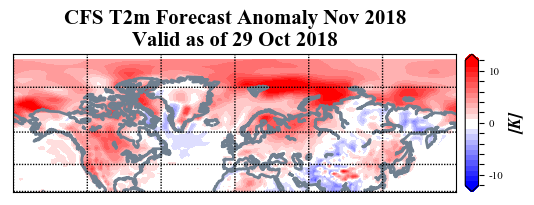
GFS is still pushing the idea of another bout of cooler weather and snow around 06 November this morning. ECM is not buying.
|
|
|
|
|
|
You need to Login to know who's really who.
You need to Login to know who's really who.
|
|
Oh the joy of checking the webcams and seeing the white stuff.
|
|
|
|
|
|
Anyway, snowHeads is much more fun if you do.
Anyway, snowHeads is much more fun if you do.
|
|
06z staying the course, though the op is a cold outlier.
|
|
|
|
|
|
You'll need to Register first of course.
You'll need to Register first of course.
|
|
Raining in Chamonix town.
|
|
|
|
|
|
|
|
| nozawaonsen wrote: |
| GFS is still pushing the idea of another bout of cooler weather and snow around 06 November this morning. ECM is not buying. |
Isn't ECMWF more often than not right compared to GFS?
|
|
|
|
|
|
|
|
|
It's only October folks, it's mostly all going to melt below the glaciers....
|
|
|
|
|
|
You'll get to see more forums and be part of the best ski club on the net.
You'll get to see more forums and be part of the best ski club on the net.
|
@kitenski, well yes, but if you are planning on skiing in the glaciers...
@südtirolistdeutsch, marginally, but not so much that you can say that GFS is always wrong and ECM is always right.
Incidentally men’s GS that was cancelling at Sölden on Sunday will now be run at Saalbach-Hinterglemm on 20 December.
|
|
|
|
|
|
|
|
@nozawaonsen, well yes, precisely why I said "below the glaciers" 
|
|
|
|
|
|
snowHeads are a friendly bunch.
snowHeads are a friendly bunch.
|
A day old, but you get the thrust.

|
|
|
|
|
|
And love to help out and answer questions and of course, read each other's snow reports.
And love to help out and answer questions and of course, read each other's snow reports.
|
Extracts from the SLF outlook for Switzerland
“On Main Alpine Ridge, very critical avalanche situation from region to region
...
Weather review to Monday, 29 October
... Since the beginning of this period of precipitation on Friday evening, and until Monday evening, the following amounts of fresh snow have been registered, in southern regions above approximately 2600 m, in northern regions above approximately 2300 m:
- Main Alpine Ridge from the Simplon region into the Bernina region and southwards therefrom: 120 to 150 cm; in western Ticino as well as from Val Bregaglia as far as the Bernina Pass as much as 200 cm;
- central Grisons, remaining parts of Upper Engadine, Val Müstair: 80 to 120 cm;
- Valleys of Visp, regions from the Susten Pass to the Glarner Alps, northern Grisons, Lower Engadine: 50 to 80 cm;
- remaining parts of the western sector of the Main Alpine Ridge along the Italian border, western parts of Lower Valais, Aletsch region, northern Grisons: 20 to 40 cm;
- in the remaining northern and western regions: 20 to 50 cm over widespread areas.
Weather outlook through Tuesday, 30 October
On Monday night, the intensive precipitation is expected to persist from the south, subsequently slacken off during the course of the day on Tuesday. The snowfall level will descend down to approximately 1200 m over widespread areas. In northern regions, skies will be overcast during the daytime, but it is expected to remain dry by and large. The southerly wind will be blowing intermittently at strong to storm-velocity. Between Monday evening and Tuesday evening, the following amounts of fresh snow are anticipated above 2000 to 2400 m:
- Main Alpine Ridge from the Monte Rosa region as far as the Bernina region, northern and central Ticino: 80 to 120 cm;
- remaining parts of Upper Valais, as well as from the Aletsch region over Susten Pass into the Maderanertal, remaining parts of Upper Engadine and Val Poschiavo: 50 to 80 cm;
- Lötschental, remaining parts of central Grisons: 30 to 50 cm;
- Lower Valais sector of Main Alpine Ridge, Sotto Ceneri, northern Grisons, Glarner Alps, southern part of Lower Engadine, Val Müstair: 20 to 30 cm; in the other regions, less.
Outlook
On Tuesday night the precipitation will come to an end in southern regions. During the daytime on Wednesday, precipitation will then recommence during the course of the day in southern regions and persist until Thursday. The snowfall level will lie at 1200 to 1800 m. In northern redgions, it will be partly sunny on both days as a consequence of strong foehn wind influence. On Thursday the foehn will come to an end during the course of the day; in northern regions skies will become increasingly overcast. The avalanche danger could well increase again from region to region in the south of Switzerland; in northern regions it will presumably diminish.“
|
|
|
|
|
|
|
|
|
|
|
You know it makes sense.
|
That’s some pretty impressive Valais numbers, particularly in the Haut Valais for the last 24 hours. And more forecast later in the week!
|
|
|
|
|
|
Otherwise you'll just go on seeing the one name:
Otherwise you'll just go on seeing the one name:
|
|
|
|
Poster: A snowHead
|
|
Expect to see some delayed resort openings in the European Alps during the next 1-3 weeks...
|
|
|
|
|
|
Obviously A snowHead isn't a real person
Obviously A snowHead isn't a real person
|
Mountains in Innsbruck all snow topped again now, although most are hidden in the clouds.
Stubai glacier was closed today and yesterday due to high winds. I can confirm that even here at 600m, this is the highest wind I have experienced in Tirol this year – enough to break a couple of branches off one of my balcony trees when it blew over in the night  Everything that isn't fastened down is regularly on the move. Everything that isn't fastened down is regularly on the move.
|
|
|
|
|
|
Well, the person's real but it's just a made up name, see?
Well, the person's real but it's just a made up name, see?
|

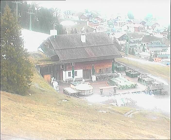
Lunch time today in Les Gets at 1700m
Last edited by Well, the person's real but it's just a made up name, see? on Wed 31-10-18 15:41; edited 1 time in total
|
|
|
|
|
|
You need to Login to know who's really who.
You need to Login to know who's really who.
|
|
Brilliant!
|
|
|
|
|
|
Anyway, snowHeads is much more fun if you do.
Anyway, snowHeads is much more fun if you do.
|
|
|
|
You'll need to Register first of course.
You'll need to Register first of course.
|
| Whitegold wrote: |
| Expect to see some delayed resort openings in the European Alps during the next 1-3 weeks... |
This is a bit of a silly statement. Of course it’s possible, but that doesn’t make it likely at this stage.
|
|
|
|
|
|
|
|
|
|
|
|
|
| nozawaonsen wrote: |
| Whitegold wrote: |
| Expect to see some delayed resort openings in the European Alps during the next 1-3 weeks... |
This is a bit of a silly statement. Of course it’s possible, but that doesn’t make it likely at this stage. |
Don't feed the troll
|
|
|
|
|
|
You'll get to see more forums and be part of the best ski club on the net.
You'll get to see more forums and be part of the best ski club on the net.
|
Who is whitegold
Why is he so clearly pushing some personal agenda.
A very odd personality
|
|
|
|
|
|
|
|
|
@Mick8417, he/she/it is a very boring troll on here.
|
|
|
|
|
|
|
|


 *
*