Lech and Zürs going to be cut off in about an half an hour as the Flexenpass will be closed and indeed the B197 between Langen and Stuben at 1600.
Last edited by Obviously A snowHead isn't a real person on Sun 13-01-19 15:00; edited 1 time in total
Well, the person's real but it's just a made up name, see?
Well, the person's real but it's just a made up name, see?
@Ajn12345, @BobinCH, and the best part about it is there is plenty more snowfall in the forecast over the next week or two.
All of the long range patterns we have been looking at, have/are panning out to create this period of great snowfall for the entire Alps, as now it is being tinkered with by NWP runs.
Last edited by You need to Login to know who's really who. on Sun 13-01-19 15:58; edited 4 times in total
Anyway, snowHeads is much more fun if you do.
Anyway, snowHeads is much more fun if you do.
@nozawaonsen, what does all this snow in Austria (I’m looking at how much is coming down in the Arlberg today) mean for the base in the long run? How long do you think it will take for it to settle and bind? Or will the avalanche risk last for a while?
Sounds like I just got out of Austria in time!! It snowed pretty much non-stop last week in the Zell am See area, only Friday saw sunshine. The roads were a bit hairy at times and it made for interesting conditions on piste, flat light, low vis and mounds of snow pushed about, but we managed to get about and skied at Zell, Hinterglemm, Maria Alm and Kaprun. Salzburg Airport had piles of snow, but fully operational, very smooth & easy departure from Terminal 2.
Last edited by You'll need to Register first of course. on Sun 13-01-19 17:49; edited 1 time in total
Then you can post your own questions or snow reports...
Then you can post your own questions or snow reports...
Good toe-in landing from a French copter on a steep slope a few days ago, to rescue an injured rider.
@nozawaonsen, what does all this snow in Austria (I’m looking at how much is coming down in the Arlberg today) mean for the base in the long run? How long do you think it will take for it to settle and bind? Or will the avalanche risk last for a while?
Good news all round really. Current base will last 'til after the lifts close. In terms of avalanche risk, a thick snowpack is generally safer than a thin one. Avalanche level will spike in the short term - particularly as the snowline now rises to ~1200m and heavier/wetter snow falls on top of cold - but is then likely to settle and bond relatively quickly under its own weight. I'd expect it to drop to 3 Tuesday/Wednesday.
The thick snowpack also means we won't have to deal with the 'old snow' problems of several of the past few seasons. 1. The snow came late and kinda all at once, rather than sitting around rotting; 2. Any old weak crystals/hoar will be buried so deeply they'll be almost impossible to trigger; 3. thicker snowpack = lower temperature gradient, so less development of weak facets in future too.
Wet slides in spring may be another matter though!!
You'll get to see more forums and be part of the best ski club on the net.
You'll get to see more forums and be part of the best ski club on the net.
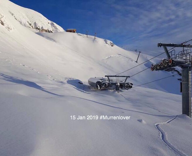
Snowing hard here less night and all day; now turned to rain in the valley but still dumping up in the resorts.
Ski the Net with snowHeads
Ski the Net with snowHeads
clarky999 wrote:
franga wrote:
@nozawaonsen, what does all this snow in Austria (I’m looking at how much is coming down in the Arlberg today) mean for the base in the long run? How long do you think it will take for it to settle and bind? Or will the avalanche risk last for a while?
Good news all round really. Current base will last 'til after the lifts close. In terms of avalanche risk, a thick snowpack is generally safer than a thin one. Avalanche level will spike in the short term - particularly as the snowline now rises to ~1200m and heavier/wetter snow falls on top of cold - but is then likely to settle and bond relatively quickly under its own weight. I'd expect it to drop to 3 Tuesday/Wednesday.
The thick snowpack also means we won't have to deal with the 'old snow' problems of several of the past few seasons. 1. The snow came late and kinda all at once, rather than sitting around rotting; 2. Any old weak crystals/hoar will be buried so deeply they'll be almost impossible to trigger; 3. thicker snowpack = lower temperature gradient, so less development of weak facets in future too.
Wet slides in spring may be another matter though!!
Cheers clarky999!
snowHeads are a friendly bunch.
snowHeads are a friendly bunch.
Avalanche level up to five in central Switzerland.
As a result of strong to storm-strength northerly to northwesterly winds, the snowfall is expected to be very intensive and persistent. The snowfall level in northern regions and in the Lower Valais will lie at 1200 to 1400 m to begin with, subsequently descending down to low lying areas in the latter part of the night. In Grisons, it will snow down to low lying areas the entire time. In the furthermost southern regions it is expected to be quite sunny as a result of the northerly winds.
Fresh snow
Between Sunday afternoon and Monday afternoon, the following amounts of fresh snow are anticipated above approximately 1500 m:
northern Alpine Ridge from the Wildstrubel as far as the Alpstein, Silvretta: 60 to 100 cm;
northern Alpine Ridge west of the Wildstrubel, remaining parts of the Valais not including Saas Fee and not including southern Simplon region, as well as the remaining parts of the Gotthard region, remaining parts of northern Grisons, remaining parts of the Lower Engadine: 40 to 60 cm;
remaining parts of the Swiss Alps and Jura region: 20 to 40 cm over widespread areas;
central Ticino and Sotto Ceneri will remain dry for the most part.
Temperature
The temperatures at 2000 m are expected to drop by midday to -7 °C in northern regions and -5 °C in southern regions.
Wind
Winds during the night will be northwesterly, blowing at storm-strength,
during the daytime at strong velocity in western regions, in the other regions at storm strength, from northerly directions.
And love to help out and answer questions and of course, read each other's snow reports.
And love to help out and answer questions and of course, read each other's snow reports.
Heavy snow in Sölden since the early hours and all day. It’s really coming down in the town since around 3pm and they just announced they are closing the roads into resort at 7:30pm local time.
Amazing first day on the slopes today, powder on all the pistes but all lifts high up closed due to winds. Not sure what will happen tomorrow given the forecasts
So if you're just off somewhere snowy come back and post a snow report of your own and we'll all love you very much
So if you're just off somewhere snowy come back and post a snow report of your own and we'll all love you very much
GFS 12z once again offering hope to those on the south side.
You know it makes sense.
You know it makes sense.
south side could use it - zermatt at about 60% of normal snowpack - fingers crossed. Heading to Lech for the first time on the 27th. hoping things stabilize and
cool heads and safety prevail after the difficulties there.
Otherwise you'll just go on seeing the one name:
Otherwise you'll just go on seeing the one name:
Avalanche level five now in western Tirol
Specifically in the Silvretta-Arlberg region, the Allgäu Alps and the western Lechtal Alps.
The height of avalanche activity is anticipated to be Monday night.
Expect road closures to be implemented on exposed routes.
Poster: A snowHead
Poster: A snowHead
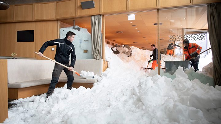
People living on the edge of the forest have been warned to sleep on the ground floor in Salzburgerland. The concern is that trees could collapse from the weight of the snow, fall onto already overloaded roofs and bring the whole lot crashing down.
An additional problem is that as temperatures briefly rise overnight there could be rain up to around 1200m before temperatures drop again in the early hours. This could soak snow on roofs and trees making it even heavier.
The pilots are incredibly skilled, all the teams selflessly brave.
Well, the person's real but it's just a made up name, see?
Well, the person's real but it's just a made up name, see?
After today’s storms a period of relative calm coming up tomorrow. Sun breaking through from the west, it should look lovely. Avalanche risk will obviously take a while to settle and convesersely the risk of people getting hurt or worse will go up as people start to get out and about trying out (and competing for) the fresh snow.
All lifts shut at the moment in Ischgl because of wind and that’s forecast to increase. Tomorrow onwards forecast is good though.
And road out of here closed.
Anyway, snowHeads is much more fun if you do.
Anyway, snowHeads is much more fun if you do.
Quite warm overnight, seemed to be raining quite high round Grenoble, zero iso is at 1400 meters so snowing down to 1000m now. Personally I wasn't too impressed with snow depths yesterday, about 15cm of fresh but it has snowed / rained a lot overnight. Better further north, there is over 30cm of fresh snow in the Bauges, nearer 50cm in the Beaufortain.
It is really a Northern French Alps exterior ranges event for the moment and the situation must be returning to normal in those areas; if you are heading out to those ski resorts (Avoriaz, la Cluzas etc) is should be pretty good once the sun comes out. Some areas of the Pyrenees also picked up much needed snow last week but it was quite localized in the Ariege region.
Last edited by Anyway, snowHeads is much more fun if you do. on Mon 14-01-19 10:12; edited 1 time in total
Looking really cold and after a few days even snowy in N-NW after 20-21 in latest ECM. Predicted polar vortex influence?
Then you can post your own questions or snow reports...
Then you can post your own questions or snow reports...
Quote:
nearer 50cm in the Beaufortain.
Les Contamines is reporting 40cm yesterday and 85cm over three days. Temperature chart looks cold but from the web cams I think it must have been a fair bit warmer at resort level (I mean steeper gradient than normal...)
After all it is free
After all it is free
End of next week is looking Snowy Snowy Snowy! take a with a large dose of salt!
You'll get to see more forums and be part of the best ski club on the net.
You'll get to see more forums and be part of the best ski club on the net.
Any thoughts on the Southern Alps (specifically Serre Chevalier) in the next couple of weeks? I was just about to pull the pin on that part of my trip but GFS is showing something in FI.
Ski the Net with snowHeads
Ski the Net with snowHeads
@Raven,
Huge differences in the GFS and EC models these days. However, it seems likely that there will be a change in the big picture these days. Less snow for Eastern Alps and more to the west and south. Yday’s monthly prognosis from EC indicates a similar situation as last winter with lots of snow to the French Alps... Also cold weather for a long period
snowHeads are a friendly bunch.
snowHeads are a friendly bunch.
UK still very uncertain, from Matt Hugo on twitter.
Morning shift underway and can honestly say anything beyond Fri/Sat is 'long range' at the moment. Model agreement even for Fri, in terms of some detail, is still lacking, let alone what may well happen next week. Picking up a signal for snowfall event next Tue mind. #toughday
And love to help out and answer questions and of course, read each other's snow reports.
And love to help out and answer questions and of course, read each other's snow reports.
Woosh wrote:
@Raven,
Huge differences in the GFS and EC models these days. However, it seems likely that there will be a change in the big picture these days. Less snow for Eastern Alps and more to the west and south. Yday’s monthly prognosis from EC indicates a similar situation as last winter with lots of snow to the French Alps... Also cold weather for a long period
Thanks
The snow I saw in that GFS run has now disappeared. Not that I’m surprised,
So if you're just off somewhere snowy come back and post a snow report of your own and we'll all love you very much
So if you're just off somewhere snowy come back and post a snow report of your own and we'll all love you very much
ECM pushes low pressure south which would favour Italy.
You know it makes sense.
You know it makes sense.
Hi Nozawaonsen, the ECM graphic above, displays several days in very quick succession, is there any way, we can display "one day at a time"
Otherwise you'll just go on seeing the one name:
Otherwise you'll just go on seeing the one name:
There's a good series of yotube videos which have a detailed analysis of model interpretation, particularly focusing on the potential for cold winter weather in the UK and Europe
These are produced as "GavsWeatherVids"... May help understanding the charts etc
Then you can post your own questions or snow reports...
Then you can post your own questions or snow reports...
Some snowfall numbers starting to come out... 7m in 7 days at Seegrube (Nordkette mid-station, 1900m): https://www.krone.at/1844008
That's insane. That beats the highest monthly totals I can find for places like Niseko, Baker, JH, Alta, Whistler.
The only place I can find with reliable stats to beat it is Tamarack in California, which got 990cm at 2100m in 1911.
For reference, 10m over a season would normally be considered a good winter.
After all it is free
After all it is free
Is that some kind of anomaly though clarky, like wind blowing it all in to the measuring area? isn't there some kind of controversy as regards measuring snow fall?
I know you have previously pointed out to me that Innsbruck is a special case! That is amazing though
You'll get to see more forums and be part of the best ski club on the net.
You'll get to see more forums and be part of the best ski club on the net.
The article points out there was a continous cover of snow at that depth.
Ski the Net with snowHeads
Ski the Net with snowHeads
8611 wrote:
Is that some kind of anomaly though clarky, like wind blowing it all in to the measuring area? isn't there some kind of controversy as regards measuring snow fall?
I know you have previously pointed out to me that Innsbruck is a special case! That is amazing though
Certainly possible, and measuring snowfall is definitely difficult! I understand they have at least three measuring stations there, which probably helps to even it out, and at least one is on the flat plateau. Can't guarantee it isn't though!
BTW just to be clear, not so much Innsbruck being the special case, but Nordkette (and then only in a Nordstau) - Patscherkofel just on the opposite side of the valley gets/got far less.


 Poster: A snowHead