UK Met Office Contingency Planners seeing a higher chance of colder than average January to March (my bold).
“TEMPERATURE:
For January and January-February-March as a whole, below-average temperatures are more likely than above-average temperatures. The likelihood of impacts from cold weather is greater than normal.
Overall, the probability that the UK-average temperature for January-February-March will fall into the coldest of our five categories is between 30% and 35%, and the probability that it will fall into the warmest of our five categories is between 10% and 15% (the 1981-2010 probability for each of these categories is 20%).
CONTEXT:
A moderate El Niño event is likely over the coming months. This increases the likelihood of the negative phase of the North Atlantic Oscillation (NAO), implying an increased chance of colder-than- average conditions.
The Madden-Julian Oscillation (MJO) is an area of enhanced thundery activity that moves eastwards through the tropics over a period of several weeks. It has recently been active and is forecast to enter a phase that often leads to negative NAO. This implies an increased chance of lower-than-average temperatures in early- to mid-January.
The stratospheric polar vortex (SPV) has recently weakened. It is influenced by various factors, including the sun, which is approaching a minimum in its 11-year cycle of activity. This increases the likelihood of a weak stratospheric circulation in late winter. On the other hand, the westerly phase of the Quasi-Biennial
Oscillation (QBO) of the equatorial winds in the stratosphere tends to favour a stronger SPV. In spite of this, long-range forecasting systems are confidently predicting further weakening of the SPV over the coming weeks, possibly cumulating in a sudden stratospheric warming event (SSW) in late December or early January. These events disrupt the SPV and substantially increase the chances of a negative phase of the NAO, implying colder-than-normal conditions during the outlook period.
For both January and January-February-March overall, the Met Office long-range prediction system, alongside systems from other prediction centres, shows an increase in the likelihood of negative NAO consistent with these global influences. Consequently, the probability of below-normal temperatures is increased compared to normal (see figure T2). The chances of disruptive cold weather, such as snow, are also higher than usual.”
Does that mean the Met Office are definitely saying it will be cold? No.
If it did turn out cold would that mean climate change was not taking place? No.
Anyway, snowHeads is much more fun if you do.
Anyway, snowHeads is much more fun if you do.
Most ski resorts in Western US will have a nice blanket of snow to greet them on Xmas, and those that don't see it on Xmas will see it on Boxing Day. That goes for Western Canada. Old Jolly Saint Nick might need to break out the closer, aka Rudolph to guide his sleigh when he hits the West Coast later tonight. That's unless of course Santa has retrofitted his sleigh with some fog lights.
Whistler had 14 straight days of recorded measurable snow that totaled up over 3 meters. North Cascades were right behind with about 2.5 meters. Farther South into Oregon the totals were a bit off with just under 2 meters with a bit of a snow then rain, then snow scenario.
Sierras are getting some as I type, that storm and the one that just came through Oregon is on its way to Utah and Colorado, Tetons could eek out some snow as well. Southern Colorado and Taos, Northern Arizona might get a few inches too. Then come Wednesday the storm will venture into the Great Plains of the mid-western states, and cause some issues for those that decide to venture out.
High pressure looks to make an appearance over the PNW around Thursday and Friday. Might be some more storms incoming as New Years approaches.
Still a pretty dreadful looking pattern out to day 10 (with the possible exception of eastern Austria). When a strong high pressure center is planted near western France, it can be extremely difficult to dislodge. Beyond day 10 is scarcely worth looking at because model skill at that range is almost zero.
Switzerland and the rest of Austria are salvageable, but it looks pretty ugly for France and Italy at the moment.
Then you can post your own questions or snow reports...
Then you can post your own questions or snow reports...
altaski8 wrote:
Still a pretty dreadful looking pattern out to day 10 (with the possible exception of eastern Austria). When a strong high pressure center is planted near western France, it can be extremely difficult to dislodge. Beyond day 10 is scarcely worth looking at because model skill at that range is almost zero.
Switzerland and the rest of Austria are salvageable, but it looks pretty ugly for France and Italy at the moment.
When you say ugly for France are you suggesting that the current snow will starting to melt/wear out or are you mainly talking about fresh snow/powder days?
After all it is free
After all it is free
After last New Years rotation of Snow /Rain daily I’m quite looking forward to a bit of Sun .
You'll get to see more forums and be part of the best ski club on the net.
You'll get to see more forums and be part of the best ski club on the net.
@Neillp, the weather is actually going to be pretty pleasant (dreadful and ugly aren’t exactly words that spring to mind). Plenty of sunshine. However, at present fresh snowfall looks limited to Austria.
Ski the Net with snowHeads
Ski the Net with snowHeads
Thanks
Sounds good to me, will be stick mainly to the pistes due to a back injury so the sun will be welcoming
snowHeads are a friendly bunch.
snowHeads are a friendly bunch.
@nozawaonsen, Happy Christmas to you too. Many thanks for your weather input. Have a great and safe season.
And love to help out and answer questions and of course, read each other's snow reports.
And love to help out and answer questions and of course, read each other's snow reports.
Absolutely agree with cad99uk. Happy Christmas and many thanks for your posts.
So if you're just off somewhere snowy come back and post a snow report of your own and we'll all love you very much
So if you're just off somewhere snowy come back and post a snow report of your own and we'll all love you very much
I am originally from North America but have now lived in Germany for three years. This has taught me that what constitutes dreadful weather in western Europe is very different than what I am accustomed to. I attribute this to a lack of familiarity for how wonderful (exciting and beautiful) weather can actually be
You know it makes sense.
You know it makes sense.
4 degree diurnal temperature range every day (2° - 6°). Can't burn off the stagnation fog before noon. The sun doesn't rise above the neighbor's roof, so it's never really sunny even if the sun is out. Almost no chance for snow out to 10 days on any medium range model. That is the very definition of dreadful. At least if it's cold the ponds freeze up for skating and the mud hardens so you don't dirty your boots. At least if it's raining, it's probably snowing in the mountains somewhere.
Otherwise you'll just go on seeing the one name:
Otherwise you'll just go on seeing the one name:
Merry Christmas to all the weather watchers out there
Poster: A snowHead
Poster: A snowHead
nozawaonsen wrote:
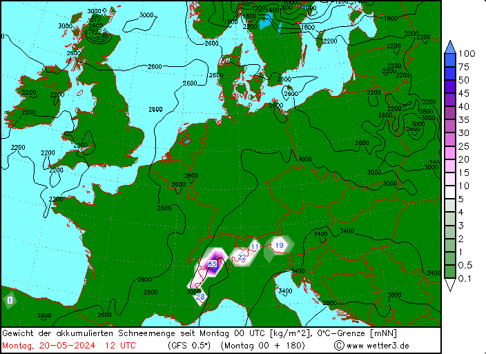
I'd be interested to know which legendary snow pocket in the Salzburgerland might be getting the forecast 106kg/m3 (or cm) of snow on that chart??
Obviously A snowHead isn't a real person
Obviously A snowHead isn't a real person
luigi wrote:
I'd be interested to know which legendary snow pocket in the Salzburgerland might be getting the forecast 106kg/m3 (or cm) of snow on that chart??
Krippenstein and Tauplitz. No massive dumps, just a succession of moderate events over a week.
The Tauplitz area has a wonderful snow microclimate but the ski area itself is poorly designed.
Well, the person's real but it's just a made up name, see?
Well, the person's real but it's just a made up name, see?
Happy Christmas to all the sH weather watchers, white or otherwise
I'd be interested to know which legendary snow pocket in the Salzburgerland might be getting the forecast 106kg/m3 (or cm) of snow on that chart??
Krippenstein and Tauplitz. No massive dumps, just a succession of moderate events over a week.
The Tauplitz area has a wonderful snow microclimate but the ski area itself is poorly designed.
Ah, so maybe further East into Upper Austria & Styria.
On the Bergfex maps the focus of next Sunday's snowfall appears to be on the Dachstein, the Totes Gebirge and along the High Tauern from the Grossvenediger to the Grossglockner
From my experience hunting for powder, in a Nordstau, the best snow falls just east of the Salzburg/Upper Austria border and north of Schladming. It sometimes seems very localized, depending on the strength of the front and which levels of the atmosphere are blocked. The glaciers near Großglockner might get more snow overall, but the hills near Tauplitz and Hinterstoder probably get some of the deepest snow in the country at low and middle elevations.
Then you can post your own questions or snow reports...
Then you can post your own questions or snow reports...
The currently modeled 10 day storm track runs from Iceland through Norway to approximately Moscow. That is a bad weather pattern for the Alps. And it is very persistent in the guidance. I hope it proves to be very wrong. The longwave features are basically in the same position at day 10 as they are today. Ugh.
After all it is free
After all it is free
Although just to avoid confusion Tauplitz is further east than the area on the chart @luigi, was referring to.
@luigi, those charts are simply a graphic representation of the GFS operational run. They’ll slip and slide and go up and down as much as the op run does. And though you can make a very rough extrapolation of snowfall they actually show precipitation not snowfall.
You'll get to see more forums and be part of the best ski club on the net.
You'll get to see more forums and be part of the best ski club on the net.
@altaski8, plenty of people will be looking forward to sunshine. So they may not share your perspective on what is bad or ugh.
Ski the Net with snowHeads
Ski the Net with snowHeads
This is the wrong season and the wrong continent for sunshine. But anecdotally it does seem to be the case that the pistes are most crowded on sunny days. Although curiously, when the sun is strongest and the snow is still deep at elevation (in late March and April), everybody disappears from the slopes.
snowHeads are a friendly bunch.
snowHeads are a friendly bunch.
And everybody likes sunshine. But ideally after a deep, stable snowpack has been established.
And love to help out and answer questions and of course, read each other's snow reports.
And love to help out and answer questions and of course, read each other's snow reports.
@altaski8, I'm guessing your name is a reference to the area in the Wasatch Range? Might have to round up a posse and run you out of town (excellent contributions to this thread notwithstanding).
So if you're just off somewhere snowy come back and post a snow report of your own and we'll all love you very much
So if you're just off somewhere snowy come back and post a snow report of your own and we'll all love you very much
altaski8 wrote:
..., but it looks pretty ugly for France and Italy at the moment.
To which part of France are you referring?
Sunny and clear here in Chatel, Haute Savoie, which ok, is only about a km from the Swiss border. Pistes in pretty good shape, despite the blacks being closed and some bare patches on some others.
When it comes to snowfall, France is a big place. So too is Switzerland as the snowfall can be totally different from one valley to the other.
You'd be right in saying many sunny days to come however. Can't see your neighbour's roof from here, but the mist is way down the valley.
You know it makes sense.
You know it makes sense.
SSW has arrived.
Otherwise you'll just go on seeing the one name:
Otherwise you'll just go on seeing the one name:
Yeah, right ...
WTF is that ?
Poster: A snowHead
Poster: A snowHead
The sudden stratospheric warming event is fun, but it remains to be seen how the PV(s) evolve and where any arctic airmasses migrate to. The EC, GFS, and CMC currently seem to disagree. I say let's freeze the English Channel one time and bring knee deep snow to the coast before global warming renders the white stuff a thing of the past.
Obviously A snowHead isn't a real person
Obviously A snowHead isn't a real person
snoozeboy wrote:
altaski8 wrote:
..., but it looks pretty ugly for France and Italy at the moment.
To which part of France are you referring?
It's variable. Some places have really good conditions - southern Alps are great from some of the stuff friends are reporting - Pra Loup has excellent piste conditions anyway. Up on the border with Italy the resorts are in great shape - Haute Tarentaise, Haute Maurienne etc. Off piste is spring like but you need to be careful as there is a lot of ice around, esp on northern slopes due to the rain. Above 2500 m you can even find some powder.
Below 1600m is marginal except where they got some man made down before the thaw. So you need to be in a resort where most of the pistes are above this level.
It's Christmas, things are never as good as later in the winter.
Well, the person's real but it's just a made up name, see?
Well, the person's real but it's just a made up name, see?
Meanwhile the High Pressure over W France has taken hold and looks to be forcing the Atlantic storms north into Scandinavia and on into E Europe, Shetland-Oslo-Riga track. I'm still clinging to today's 00z scenario that the High slips out beyond Biscay and the storm track goes more Edinburgh-Copenhagen-Warsaw and the associated fronts sweep down into the Eastern half of Austria and we'll see some snow on the last two days of 2018!
There is an arctic cold breakout into W Europe way off in far FI, around 10th Jan, is that how the GFS is resolving the SSW event??
@Cheapski, scroll back a few pages for some earlier discussion. It’s a relatively rare (once every other year or so) dramatic shift in the temperature way up in the stratosphere. This has the potential to disrupt or indeed split (currently looking quite likely) the polar vortex, the pool of cold air circulating above the Arctic.
It’s tricky to predict the outcome because it won’t become clearer for a while (week or so). If the vortex is completely split you can end up with two or more “daughter” vortices, their position will determine the impact on the weather. But it can and often does lead to a substantial fall in temperatures across Europe.
luigi, could be. Models are going to struggle to model it until it’s impacts become clearer.
Anyway, snowHeads is much more fun if you do.
Anyway, snowHeads is much more fun if you do.
My understanding is that this SSW event might lead to colder than normal (below average) January but not necessarily "snowier".
That could be good for snow making but also it could mean that I leave my 104mm wide skis at home and deploy something in the mid 80's and rip the groomers in January.


 Poster: A snowHead