@Skiwi 55, you mean the ones from wetterzentrale.de with the black background? Those ones update every six hours so you might as well just bookmark that page of the thread.
Obviously A snowHead isn't a real person
Obviously A snowHead isn't a real person
ECM now going for a cooler version for next week.
Well, the person's real but it's just a made up name, see?
Well, the person's real but it's just a made up name, see?
@Skiwi 55, you mean the ones from wetterzentrale.de with the black background? Those ones update every six hours so you might as well just bookmark that page of the thread.
Got it, thanks!
Anyway, snowHeads is much more fun if you do.
Anyway, snowHeads is much more fun if you do.
Ricklovesthepowder wrote:
How is Utah looking for the next week or so?
Storm coming in tonight for the Cottonwood Canyons. 9"-18" forecast for the 24 hour period once the snow starts falling Sunday late afternoon into Monday.
Better conditions for the week of March 6th-10th in PNW and BC as the storms tracking off the Pacific stay to the North. Models past that are starting to show some potential for Utah and CO.
As per the usual weekly Cali dump, it is dumping in Tahoe again. About 20-40cm for most Tahoe areas. already from last night, with another storm underway on Sunday for another 20+cm. Cali gets a break while the storms track to the North.
I did ski Snowbird on Friday, and it was a balmy 8C on mountain. Snow still stayed relatively chalky and did not turn to mush.
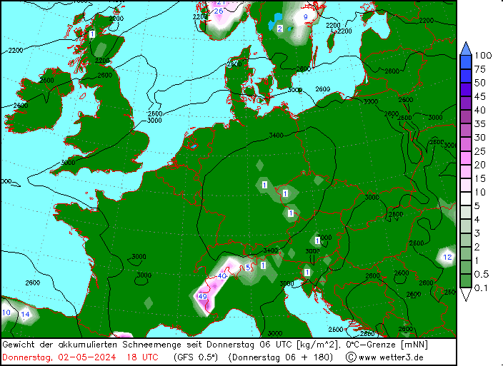
This gives a feel for snowfall anomalies in the coming week. It's based on the GFS op run so keep that in mind, but a good spell coming up for the northern side of the Alps.
Then you can post your own questions or snow reports...
Then you can post your own questions or snow reports...
Very cold 18z run.
After all it is free
After all it is free
This Wednesday to Sunday: Fairly warm.
Next Monday beyond: Very cold on both EC and GFS and their ensemble means are weaker than the op run. GEM and GEPS is slightly cold.
Quite typical of March. Several Cold blasts with warmer periods in between.
You'll get to see more forums and be part of the best ski club on the net.
You'll get to see more forums and be part of the best ski club on the net.
@Skiwi 55
Quoted from Forecast guide thread.
slikedges wrote:
I thought it'd be useful to store this here too (NB 8E 46N):
And love to help out and answer questions and of course, read each other's snow reports.
And love to help out and answer questions and of course, read each other's snow reports.
France
So if you're just off somewhere snowy come back and post a snow report of your own and we'll all love you very much
So if you're just off somewhere snowy come back and post a snow report of your own and we'll all love you very much
Maersk wrote:
Where is all this Austrian snow?
The forecasted amounts for Austria started to reduce towards the end of last week!! On the latest overnight GFS ensembles, i can't see any significant snow for Salzburg region for the next week or so. May be a few top ups but nothing major, unless I am reading the charts wrong!!
Typical, always said Austria was too low.................
Went last year for the first time and quite enjoyed it - it was obviously just luck....
Still, nothing worse than a week in a 2500 metre high ski resort with all the lifts closed due to high winds and no visibilitay, m'sieu.
Yes, i have done that........
At least it tends to be grass under the snow so your gear does not get destroyed. Looks like it will just be my liver that gets damaged.
Otherwise you'll just go on seeing the one name:
Otherwise you'll just go on seeing the one name:
PS. Puts on foil hat and metal suit with regard to the too low Austrian comment.....................
Poster: A snowHead
Poster: A snowHead
@Maersk You ski enough you will come across days like the high wind, upper mtn closures on a regular basis. What's really the bummer is that the 20-30cm forecasted (or whatever the amount is) snowfall ends up blowing away or leaves a nice hard wind buff that doesn't do anyone any good, especially for the off-piste skiers.
Obviously A snowHead isn't a real person
Obviously A snowHead isn't a real person
Yes the problem with going high is that on a 6 day ski holiday there is a risk of losing days due to lift closures. Today for example
Well, the person's real but it's just a made up name, see?
Well, the person's real but it's just a made up name, see?
06z below. 12z just rolling out.
Looks like Austria would do pretty well out of that if it came off.
Then you can post your own questions or snow reports...
Then you can post your own questions or snow reports...
There does seem to be disparity between those very nice looking charts and snowforecast/bergfex etc which are predicting only a dribble within the reliable timeframe for eastern Austrian resorts.
@nozawaonsen, @snowheads68, what is the current GFS thinking on when the majority of the snow in those charts above is likely to fall?
After all it is free
After all it is free
@hd, snowforecast.com and the chart above are both based on the GFS op run. The chart updates faster than snowforecast.com does.
The charts above run to +180 (so next 7.5 days) or +192 (so next 8 days).
The snowfall amounts at that range are likely to varyquute a lot on the GFS op run (and so will vary on snowforecast.com and those charts too since they all draw on the same original data).
But GFS currently shows a band of snow crossing the northern Alps tonight into tomorrow, Thursday into Friday and Sunday into Monday.
You'll get to see more forums and be part of the best ski club on the net.
You'll get to see more forums and be part of the best ski club on the net.
@hd Bergfex is EC, so best to use that for a comparison.
Ski the Net with snowHeads
Ski the Net with snowHeads
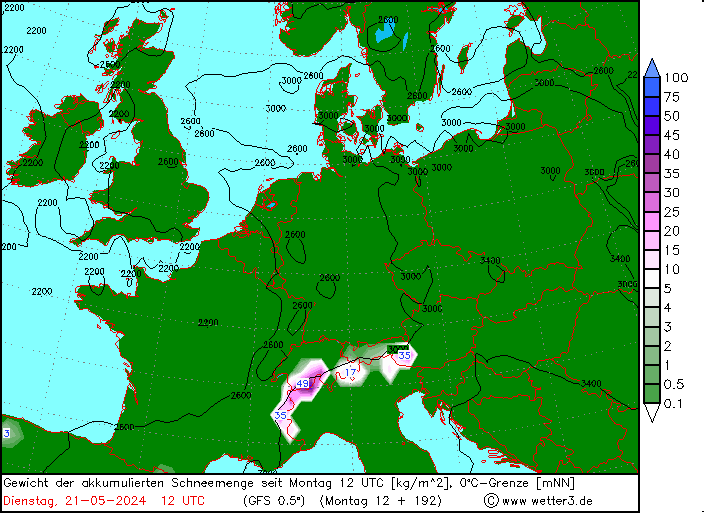
So this is the 12-15 March. Nice and snowy for most of the Alps, including Austria.
And 18-20 March with snow from the south, but does look like a Pineapple...
Last edited by Ski the Net with snowHeads on Mon 6-03-17 21:48; edited 1 time in total
snowHeads are a friendly bunch.
snowHeads are a friendly bunch.
Pineapple Express, @Jellybeans1000
And love to help out and answer questions and of course, read each other's snow reports.
And love to help out and answer questions and of course, read each other's snow reports.
Jonpim wrote:
Pineapple Express, @Jellybeans1000
Sorry it's actually a pineapple, a Pineapple Express is reserved for the US West Coast. A pineapple is a moisture laden low, with a substantial tropical feed.
You can see the green flow coming out of the low above France across North Africa, which comes from the tropics. This is the tropical feed. Because of their tropical feed, these systems tend to be warmer than their cold front counterparts. So higher FLs, but heavier snowfall above that.
But this one is 12 days out, so anything could happen in the interim.
So if you're just off somewhere snowy come back and post a snow report of your own and we'll all love you very much
So if you're just off somewhere snowy come back and post a snow report of your own and we'll all love you very much
I was checking weather forecast for Saalbach at Snowforecast and I become worried. They predicted heavy rain and freezing levels above 1500m. EC is also predicting rain...But then I looked on pictures nowa and snowheads provided and I don't understand where will all the forecasted now fell? Also I can see from the map that the Snow line will be at 600m...
If you combine Gfs, EC and Snowforecast forecasts together, they don't make any sense... Very confused...
You know it makes sense.
You know it makes sense.
@matejp, you are comparing the same thing. Snowforecast.com, the GFS op run and the maps above are ALL drawing on the same data.
Snow tomorrow in Saalbach looks like having a snowline around 500-700m. Thursday currently 1100-1400m (though that could shift yet) and the week after looks lower again, but that's a bit far out anyway.
Otherwise you'll just go on seeing the one name:
Otherwise you'll just go on seeing the one name:
Gah, i still dont understand where you find all forecasts. Would any kind soul link a good long time forecast, v13 if possible (for south/west alpes)?
Poster: A snowHead
Poster: A snowHead
staffsan wrote:
Gah, i still dont understand where you find all forecasts. Would any kind soul link a good long time forecast, v13 if possible (for south/west alpes)?
@matejp Snowforecast.com has some differences from GFS. It is basically GFS output run through a terrain modeller. To better forecast snow on different aspects and different wind directions. It got a better resolution than GFS. Compared to high res GFS, maybe not.
Well, the person's real but it's just a made up name, see?
Well, the person's real but it's just a made up name, see?
For goodness sake don't waste any time looking at CFS out to 85 days...
"There's too much confusion
I can't get no relief..."
ECM seems to be going along with the cooler option for next week now as well. Been doing that for a couple of runs now. GFS 1 ECM 0 in this case?
Then you can post your own questions or snow reports...
Then you can post your own questions or snow reports...
@nozawaonsen,
Quote:
you mean the ones from wetterzentrale.de with the black background?
I like the way that you used the colour of the background to specify the graph, thus avoiding the need to deploy an adjective describing the character of the data lines.
After all it is free
After all it is free
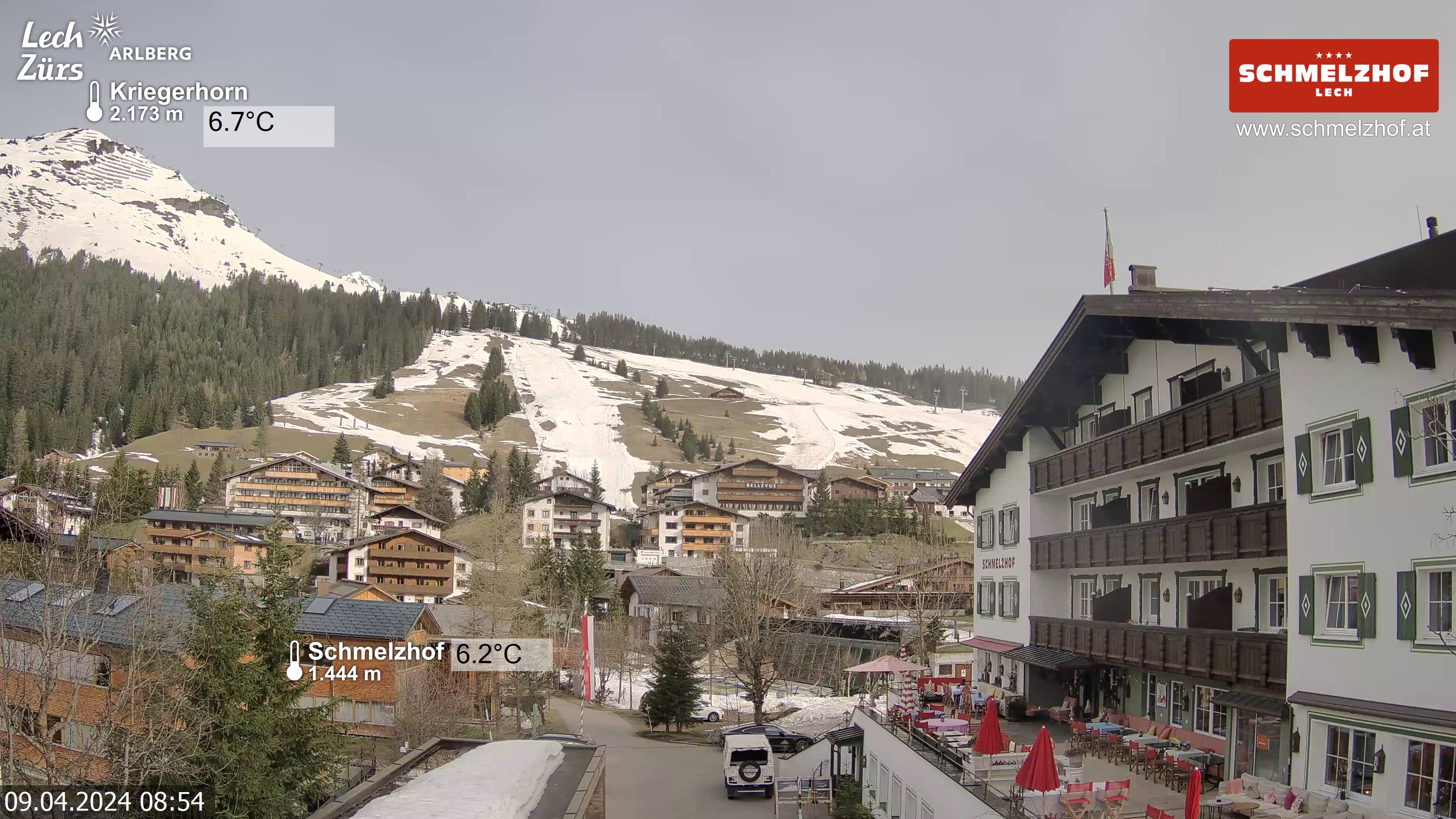
Lech, Austria, seeing best conditions of the season.
You'll get to see more forums and be part of the best ski club on the net.
You'll get to see more forums and be part of the best ski club on the net.
Solid snowfall in Tirol too. Kühtai today (Will Robson photo):
Ski the Net with snowHeads
Ski the Net with snowHeads
Overall the coming eight days will see above average precipitation for the northern Alps and below average temperatures
Within that there are four or five days of slightly milder weather coming and the snowline could be relatively (though not massively) high before more cold weather sets in again. Winds still quite strong in the west.


 Poster: A snowHead