Lots of interest in September although the start of the season for most is still 3 months away and as with last year interest will have died away by the middle of march.
Obviously A snowHead isn't a real person
Obviously A snowHead isn't a real person
i spend 6 months of the year reading this thread and the other 6 months waiting for it start again
Well, the person's real but it's just a made up name, see?
Well, the person's real but it's just a made up name, see?
Overall temperatures look like remaining above average for at least the next week. Beyond that there are continuing suggestions of cooler weather developing in eastern Europe, but at this point it's less clear whether it will push west. In the meantime some rather pleasant autumn weather to enjoy.
Last couple of GFS runs suggesting possibility of a cold spell around 07 October. That's right on the low res, high res split and also over a week away so I'm not sure I'd take it that seriously, but it'll be worth seeing if it gets picked up in this evening's runs.
Are the warmer temperatures anything to be worried about or pretty meaningless at this time of year?
You'll get to see more forums and be part of the best ski club on the net.
You'll get to see more forums and be part of the best ski club on the net.
Raven,
I am sure the great nozawaonsen, will say normal variation. We are still in the period where what is going on really has no effect on the eventual snow pack. We will be hoping to see a general trend of reduced temperatures as winter approaches. This trend should reduce ground temperature and hopefully allow the first real heavy snow falls to properly adhere to the ground. Experience tells us that any snow fall we get in the next couple of months always has the potential to melt completely during these warmer spells. Indeed a very heavy snowfall whilst the ground is still warm that does not fully melt may produce an unstable snow pack.
The Grand Motte in Tignes looked great a week or so ago but has gone back to something like its summer hue. This cycle may happen again before winter. I think it was 2011/12 when there was no significant snow in the French Alps before the end of the first weekend of December but within a few weeks the conditions were great. The weather is endlessly fascinating but not something to worry about. I am hopefully to be out at Christmas. I will only start to be concerned if snow coverage is bad or non-existent 10 or so days before and general temps are abnormally warm. Ideally, I will be hoping to see everything becoming permanently white above 1500m from about the third or fourth week of November.
Ski the Net with snowHeads
Ski the Net with snowHeads
Raven, like Mark1863 says absolutely no reason to worry. Indeed more generally the weather is rarely something one should worry about (unless you are caught unprepared on the side of a mountain with the wrong kit in a storm!). But yes at this stage it's more about curiosity and autumn leaves. I wouldn't mind something to get the glaciers in shape for November, but none of what happens now really makes any difference to later in the season.
snowHeads are a friendly bunch.
snowHeads are a friendly bunch.
The Met Office issues a three month look ahead forecast for contingency planners, so that's people who have to make planning decisions way in advance (emergency planners, logistics and transport etc, etc). It is heavily caveated and clear that it is not something to be considered as a predictive tool.
Nevertheless the latest update issued at the end of last week makes the following comments which may be of interest as we peer towards winter...
"There are currently no significant sea surface temperature anomalies across the tropical Pacific and therefore neither El Niño nor La Niña conditions prevail. Computer models favour a continuation of near-neutral conditions in the coming months."
"However, models have a weak signal for slightly higher-than-average pressure to the north of the UK, suggesting a slight weakening of the prevailing mean westerlies, which could allow a greater-than-average incidence of blocking patterns."
"... a blocked pattern in October could lead to warmer-than-average conditions, whereas in November and December will most likely be associated with lower-than-average temperatures."
All pretty marginal, but worth a look if you are interested.
And love to help out and answer questions and of course, read each other's snow reports.
And love to help out and answer questions and of course, read each other's snow reports.
One factor could be the unusually early establishment of extensive snow cover over Siberia in September this year (positive anomalies in blue, negative in red):
Normally this doesnt happen until well into October, although October is also the month that appears to be the most important for the link between Siberia snow cover and early winter atmospheric blocking. More snow cover maps here:
So if you're just off somewhere snowy come back and post a snow report of your own and we'll all love you very much
So if you're just off somewhere snowy come back and post a snow report of your own and we'll all love you very much
Thanks for the reassurance guys. This is my first time heading to Europe to ski so haven't really taken much notice of weather patterns over the alps before. I also get jittery about weather as I have this crazy belief that I'm a bit jinxed when it come to snow. Somehow I managed to get torrential downpours instead of powder in Japan (Honshu, not Hokkaido) but hey my luck has to turn around sometime.
You know it makes sense.
You know it makes sense.
Raven, That's great news, I'm heading to America
Otherwise you'll just go on seeing the one name:
Otherwise you'll just go on seeing the one name:
nozawaonsen, keep the updates coming, i'm slowly becoming addicted to this thread!!!
Poster: A snowHead
Poster: A snowHead
[quote="nozawaonsen"]For now despite occasional hints (see above) any below average temperatures looked like remaining bottled up in the east.
Any chance of getting rid of this FF-ing blocked atmosphere in the near future?
Haven't seen a decent atlantic flow for at least 2 months now.
Seems like western storms are a thing of the past.
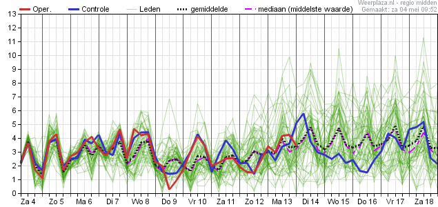
Wind speed should be @ 8 m/s on average in this graph below, with regular peaks above 10.
It's autumn now, but the atmosphere keeps acting like it's mid august.
Then you can post your own questions or snow reports...
Then you can post your own questions or snow reports...
GFS 12z op run also going for quite a sharp cool down at the end of next week this evening. That would bring snow to relatively low levels if it came off.
Will see over the next day or so whether this continues to build support.
Last edited by Then you can post your own questions or snow reports... on Tue 8-10-13 21:01; edited 2 times in total
After all it is free
After all it is free
I think snow forecast uses that model? It is showing cold coming to the alps Wednesday / Thursday.
When is the first big lasting dump this year? November 26TH??
You'll get to see more forums and be part of the best ski club on the net.
You'll get to see more forums and be part of the best ski club on the net.
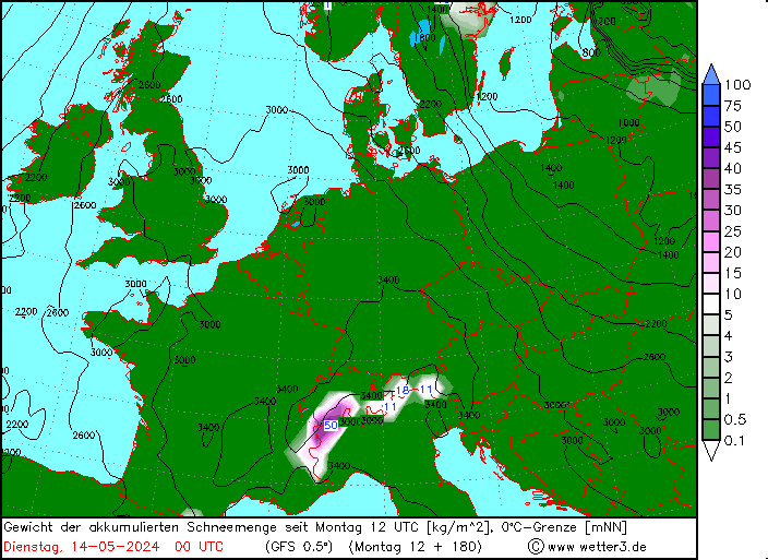
So a big shift now looking increasingly likely at the end of next week. This morning's output sees substantial support for a switch to much colder weather over much of Europe with the snowfall line dropping below 1000m on Thursday night, Friday morning. And from the chart above you can see that 50cm or more in places is not out of the question.
Ski the Net with snowHeads
Ski the Net with snowHeads
Generally colder (initially much colder) than average spell heading for the Alps for what looks like a week from Thursday.
snowHeads are a friendly bunch.
snowHeads are a friendly bunch.
The latest update from GSF (see chart above) has most of the snow on Thursday/Friday in the Arlberg, but much of Tirol looks like it will see a fair amount of snow. Being early/mid October it is unlikely to last long (certainly not lower down) and from 17 October temperatures look above average for a while. It will nevertheless start the build up on the glaciers and if you happen to be within reach Sunday Monday there could be fun to be had. Saturday currently looks pretty windy.
And love to help out and answer questions and of course, read each other's snow reports.
And love to help out and answer questions and of course, read each other's snow reports.
I'm predicting lots of eastern uk snow this winter, with similar systems as 2010... Fingers crossed
So if you're just off somewhere snowy come back and post a snow report of your own and we'll all love you very much
So if you're just off somewhere snowy come back and post a snow report of your own and we'll all love you very much
Guess who is on Home office all next week and only a couple of hours from Hintertux!
You know it makes sense.
You know it makes sense.
WRF showing a detailed breakdown of how Thursday night, Friday morning breaks down for now.
I'm predicting lots of eastern uk snow this winter, with similar systems as 2010... Fingers crossed
Is that based on any facts or just wishful thinking. Just for planning purposes, freezer filled up, cross country skis positioned by the door etc.
Complete wishful thinking, although the low pressure that's just drifted down our east coast is very similar and we've now had a good month or two of system after system bashing in to the north of the UK which, if it was winter, would have dragged lots of freezing cold northerlies our way.
I can feel it in my bones I tell thee!
Well, the person's real but it's just a made up name, see?
Well, the person's real but it's just a made up name, see?
Well it is snowing now in the 3Vs.
I imagine that anything that falls above 3,000 metres from now on will start accumulating and possibly anything above 2,600 metres has a chance of staying?
Here's the latest from SLF (it's the Swiss avalanche institute so is talking about the situation in Switzerland rather than the Alps as a whole - the focus for snowfall looks like being western Austria).
Onset of winter, snowfall down to low altitudes
"It began to snow from the northwest on Thursday. The snowfall level rapidly dropped from about 2000 m down to 1000 m. By Thursday evening several centimeters of snow had fallen widespread, on the northern flank of the Alps as much as 10 cm.
On Friday and Saturday, skies will be generally overcast, amidst snowfall above approximately 1200 m. Until Friday, the center of the snowfall will be in Grisons, between Friday evening and Saturday evening it will move to the western and central sectors of the Main Alpine Ridge and south thereof.
Between Thursday evening and Saturday evening the following amounts of snowfall are anticipated above approximately 1800 m:
regions south of the Rhone-Rhine line: 30 to 50 cm, from place to place more
remaining regions: 10 to 30 cm
To begin with, moderate to strong velocity northerly winds are expected at high altitudes. On Friday, the winds will shift to southerly."
Perfect noz, you are just the translator and messenger, but a nice message.
Then you can post your own questions or snow reports...
Then you can post your own questions or snow reports...
Heavy snow down to 750ish metres here atm.
After all it is free
After all it is free
clarky999, hope you manage to get some turns in. Looks like warming up again in about a week.
You'll get to see more forums and be part of the best ski club on the net.
You'll get to see more forums and be part of the best ski club on the net.
nozawaonsen, Annoyingly I'm working the next two days, so hoping it'll stick around until Sunday. Would be nice if there's enough snow somewhere like Kuhtai to do a bit of skinning and avoid the mad glacier 'first pow of the season' frenzy, but not convinced that'll happen this time around.
Ski the Net with snowHeads
Ski the Net with snowHeads
clarky999, Sunday should be good, less windy and clearer.


 Poster: A snowHead