Ski Club 2.0 Home
Snow Reports
FAQFAQ

Mail for help.Help!!

Log in to snowHeads to make it MUCH better! Registration's totally free, of course, and makes snowHeads easier to use and to understand, gives better searching, filtering etc. as well as access to 'members only' forums, discounts and deals that U don't even know exist as a 'guest' user. (btw. 50,000+ snowHeads already know all this, making snowHeads the biggest, most active community of snow-heads in the UK, so you'll be in good company)..... When you register, you get our free weekly(-ish) snow report by email. It's rather good and not made up by tourist offices (or people that love the tourist office and want to marry it either)... We don't share your email address with anyone and we never send out any of those cheesy 'message from our partners' emails either. Anyway, snowHeads really is MUCH better when you're logged in - not least because you get to post your own messages complaining about things that annoy you like perhaps this banner which, incidentally, disappears when you log in :-)
Username:-
 Password:
Remember me:
👁 durr, I forgot...
Or: Register
(to be a proper snow-head, all official-like!)

The All New 21/22 Weather Outlook Thread

 Poster: A snowHead
Poster: A snowHead
This might be of interest here, how increased levels of precipitation in the Julian alps have reduced the amount of glacial loss in that area (not that it has much glaciation) https://www.severe-weather.eu/cryosphere/glaciers-melting-faster-longer-few-alps-challenge-global-warming-positive-mass-balance-rrc/
snow conditions
 Obviously A snowHead isn't a real person
Obviously A snowHead isn't a real person
Woosh wrote:
Looks like we might have another La Nina event this winter:

https://www.severe-weather.eu/global-weather/enso-la-nina-watch-autumn-winter-2021-2022-usa-europe-fa/

As is said in the article: we did not see the expected development in North America, probably due to the strong SSW.

Low probability for a third SSW in a row this winter, but cannot be ruled out.

An early and speculative sign of wet and mild winter for the UK and the Nordics and dry weather for the Alps?

Or will we see low pressure system to Europe and cold weather as indicated by the limited research for a second year La Nina like 2018?


Brrrrr, hope not! Whilst the snow we had here was plentiful, we also had a 2-3 week spell of -12 to -20C in January that particular Winter. A very warm March, too….not the best Spring skiing, for sure.
snow report
 Well, the person's real but it's just a made up name, see?
Well, the person's real but it's just a made up name, see?
What an amazing summer, indeed what an amazing year in the west Cool wall to wall sunshine, warm and very dry will very little flooding last winter and loads of snow. No doubt it will change back at some time but enjoy it while it lasts this week. Lots of days like this morning at Glencoe. It’s been a good summer to build the new base cafe.
http://www.winterhighland.info/cams/glencoe/
snow report
 You need to Login to know who's really who.
You need to Login to know who's really who.
Cloudy and a bit nippy here!
snow report
 Anyway, snowHeads is much more fun if you do.
Anyway, snowHeads is much more fun if you do.
September strikes again as it often (indeed always unless I am much mistaken) does at the start of autumn.

Normally see the first ripples of winter at some point this month with snowfall briefly descending before rapidly retreating.
latest report
 You'll need to Register first of course.
You'll need to Register first of course.
The data is in and it has been the 9th hottest summer on record with drier and sunnier weather than average across the uk except the far south east which has been wetter than average.
Scotland, Northern Ireland, Wales and the north west of England have been particularly dry. The central highlands have been particularly sunny. It’s been a great year in the hills so far.

https://www.metoffice.gov.uk/about-us/press-office/news/weather-and-climate/2021/one-of-the-hottest-summers-on-record-for-scotland-and-northern-ireland
snow report
 Then you can post your own questions or snow reports...
Then you can post your own questions or snow reports...
conveniently the records in the images only go back as far as 1981
snow report
 After all it is free Go on u know u want to!
After all it is free Go on u know u want to!
@Mr.Egg, I have to say it should show records over at least 100 years. I suspect this would only add to the validity of global warming, but it opens up accusations of utilising only data that suit a specific point.
ski holidays
 You'll get to see more forums and be part of the best ski club on the net.
You'll get to see more forums and be part of the best ski club on the net.
Certainly no sign of winter weather at present. Indeed Austria like many parts of the Alps has been enjoying some very fine and stable late summer weather. Perfect for hiking this morning with the Dachstein glacier looking snowy above.

After hot weather in June and July August in Austria was colder, cloudier and wetter than average.

https://www.zamg.ac.at/cms/de/klima/news/august-2021-kuehl-trueb-nass

That said overall the summer as a whole was warmer than average and even August was above the 1961-1990 mean.

https://www.zamg.ac.at/cms/de/klima/news/sommer-2021-sehr-warm-und-teils-nass-teils-trocken
latest report
 Ski the Net with snowHeads
Ski the Net with snowHeads
Hottest September day in Scotland for 115 years. 26c in the Cowal peninsular today. Just fabulous Cool
snow report
 snowHeads are a friendly bunch.
snowHeads are a friendly bunch.
Up to St Andrews for a few days golf on Monday. Very glad it’s cooling down myself
snow report
 And love to help out and answer questions and of course, read each other's snow reports.
And love to help out and answer questions and of course, read each other's snow reports.
I guess the marmots will be studying this with interest https://www.severe-weather.eu/global-weather/polar-vortex-returns-usa-europe-winter-2021-2022-fa/ perhaps time to get in extra supplies whilst the sun is shinning.
ski holidays
 So if you're just off somewhere snowy come back and post a snow report of your own and we'll all love you very much
So if you're just off somewhere snowy come back and post a snow report of your own and we'll all love you very much
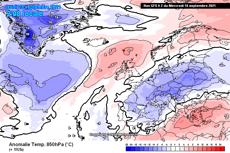
Some properly chilly weather for the time of year starting to crop up on GFS in the last week of September. Too far out to take seriously, but ECM also toying with cooler conditions so potentially a sign of things to come.
snow conditions
 You know it makes sense.
You know it makes sense.
Atmospheric River on tap for the PNW this weekend. Some cool air coming down from the Gulf of AK will hook up with some moist and warm air from the South. Will be much needed precipitation that will hopefully knock down the fires burning in WA, OR and ID. Possibly some moisture for Northern CA as well.

Cascades and BC interior should see some snow above 1,800 meters on Saturday/Sunday. Same for Central ID and parts of MT.
ski holidays
 Otherwise you'll just go on seeing the one name:
Otherwise you'll just go on seeing the one name:
Spot the difference


snow conditions
 Poster: A snowHead
Poster: A snowHead
@polo, it’s going to get a lot colder then! The electronic forecasting gods speak as one.
latest report
 Obviously A snowHead isn't a real person
Obviously A snowHead isn't a real person
@twoodwar, yes they do, and exactly one year apart, to the hour
snow conditions
 Well, the person's real but it's just a made up name, see?
Well, the person's real but it's just a made up name, see?
NW might get an early start on the new season, Cham Meteo calling 20-30cm at 2500m Sat-Sun


East looks better placed as things stand for the following weekend (25-26)


I'll post some thoughts on the season outlook later, it's near that time where my focus here will switch to weather prognostics rather than offering epidemiology expertise.
snow report
 You need to Login to know who's really who.
You need to Login to know who's really who.
It’s started above 2000m…
latest report
 Anyway, snowHeads is much more fun if you do.
Anyway, snowHeads is much more fun if you do.
@polo, ahhhh! Missed the year!
snow conditions
 You'll need to Register first of course.
You'll need to Register first of course.
Same system should drop roughly the same on top of Hintertux. Snow-line down to about 2100m tomorrow.
snow conditions
 Then you can post your own questions or snow reports...
Then you can post your own questions or snow reports...
Both ECM and GFS have been backing away from a colder shot in last week of September mind you.
ski holidays
 After all it is free Go on u know u want to!
After all it is free Go on u know u want to!
Some pictures of snowy (& closed) alpine passes https://www.wetteronline.de/wetterticker/b3b8364e-a5e4-4037-8d72-96740f0beec4 . Picture from Arolla with considerable snow apparently at village level, not far from Verbier.
ski holidays
 You'll get to see more forums and be part of the best ski club on the net.
You'll get to see more forums and be part of the best ski club on the net.
The low anomaly around 26th has been pushed further away towards Ukraine, partly due to a separate deep atlantic low forming and blowing up high pressure over western europe. The relatively active hurricane season isn't helping model forecasting accuracy either in the short term.

Here's the updated mean ECM for 26th. Note these are pressure charts, not temperature, so while there is a casual relationship of course between low pressure and low temperature the numbers themselves (-10, -20) are not translatable.


But with NAO and AO about to head negative during the last week of Sep the background is still favourable for a cool spell (somewhere Madeye-Smiley ) with blocking to the north and mid atlantic.
The day 10 mean pressure anomaly charts below.....UK looks set for some autumnal weather but with a bit of luck that trough could disrupt further E/SE towards the alps.

ECM


GFS


GEM
snow conditions
 Ski the Net with snowHeads
Ski the Net with snowHeads


Is it snowing yet?
snow conditions
 snowHeads are a friendly bunch.
snowHeads are a friendly bunch.
Update on 30th Sep, ECM mean pressure


Looking at the changes (above) over the last week or so, the general synoptic picture wasn't bad but high pressure has ended up at a lower lattitude than forecast (as is often the case...memories of so many failed undercuts), notably in the east atlantic but also with the scandi high sinking into central europe. The low anomaly over the UK has split in two, with only a shallow trough making inroads to the east, so not much snow in the forecast, but certainly a cool spell

ECM temp anomaly


Heading into Oct, by next weekend the low over the UK intensifies as it struggles to find an escape route and is joined by some ex-tropical energy. All 3 models show similar mean pressure chart, so I'll just post the one that's a blend of the other two.


NAO/AO forecast to stay negative into early Oct before rebounding, and longer term modelling suggesting strat winds will be slowing down to well below average in mid-late Oct....which should keep the blocked theme going (increased odds of colder than average mid lattitudes)
latest report
 And love to help out and answer questions and of course, read each other's snow reports.
And love to help out and answer questions and of course, read each other's snow reports.
Good grief it’s properly raining in North Yorkshire this morning for what feels like the first time since May Shocked

Have to go back to December before that. Hope it doesn’t just rain constantly now until next May !
snow conditions
 So if you're just off somewhere snowy come back and post a snow report of your own and we'll all love you very much
So if you're just off somewhere snowy come back and post a snow report of your own and we'll all love you very much
Peter S wrote:
Good grief it’s properly raining in North Yorkshire this morning for what feels like the first time since May Shocked

Have to go back to December before that. Hope it doesn’t just rain constantly now until next May !


Yes proper change in the weather, walked the dog in shorts yesterday, full waterproofs today and cold hands!
snow report
 You know it makes sense.
You know it makes sense.
Can view 10 day precip totals for UK on this link, currently 6 models at the top of graph to view

https://meteologix.com/fr/model-charts/euro/united-kingdom/accumulated-precipitation/20211007-0000z.html

Spoiler:


A few Op runs for early next week (Oct 3-6th) suggest movement of UK trough in a SE direction towards alps, but we've seen these get watered down recently (NE exit is the default until proven otherwise)......too far away to be in any way reliable, next few days are crucial

snow conditions
 Otherwise you'll just go on seeing the one name:
Otherwise you'll just go on seeing the one name:
Here‘s what that low pressure looks like over the UK on this evenings GFS.
ski holidays
 Poster: A snowHead
Poster: A snowHead
that sunday low is now showing at 965-970mb on all of the 6 main models, which equates to over 100mph winds.
Found a table on this link with the Saffir-Simpson Hurricane scale...Cat 2... "considerable damage to shrubbery", but likely to be some localised disruption.

http://marinewaypoints.com/marine/wind.shtml

UKMO update is similar to above for Sunday


Previous mean pressure chart will have hidden this -30mb anomaly that the Op's are now showing...(mean is now down to -20mb)


As for snow, GFS as usual is the most progressive (SE)...so it's either playing a blinder or barking up the wrong tree....will start warm in the west (SW flow) so high altitude should do relatively well
ski holidays
 Obviously A snowHead isn't a real person
Obviously A snowHead isn't a real person
Looking at latest T+120 charts (sunday night - mon morning), UKMO on top has the low moving quickly N, while ICON (below) keeps it over Scotland allowing cooler NW air flow to reach alps.
The temperature charts on the right show UKMO is 4 degrees warmer for the NW alps at 1500m, +8 instead of +4.
Note the different tracks of hurriance Sam in the bottom left corners might be fueling the uncertainty


Charts are 6 hrs apart due to ICON being 6z but the differences are still unusual 4-5 days out
latest report
 Well, the person's real but it's just a made up name, see?
Well, the person's real but it's just a made up name, see?
After a very pleasant and warm weekend up to 25 degrees, beer garden weather, (we were at Chiemsee, nice views down towards Salzburg and glimpses of the mountains around Fieberbrunn) it has turned noticeably autumnal over the past couple of days. I see snow is forecast up high next week in parts of the Tirol.
snow conditions
 You need to Login to know who's really who.
You need to Login to know who's really who.
UK Met Office said we are currently in the lowest tenth percentile of model reliability.
So none of this may happen, but it looks wet between Aosta and Lugano....while GFS has been showing 50-80cm snow on the southern side (out to wednesday)


Credit to GFS for being so consistent with this secondary low that spins out of the main northern low by Tuesday towards alps, other models were very late to agree on this. Sam still blowing furiously in the bottom left.


Still anyone's guess on snow, but for NW i'd say 20-30cm at 2500cm with snowline briefly below 2000m.
Beyond that looking dry out to mid Oct on the ensembles, with a FL somewhere between 1600m and 3600m.....give or take a few hundred more meters.

snow report
 Anyway, snowHeads is much more fun if you do.
Anyway, snowHeads is much more fun if you do.
Hintertux looking pretty tempting later this week… 30-50cm snow likely up top.
ski holidays
 You'll need to Register first of course.
You'll need to Register first of course.
Next 2 days snowfall looks concentrated close to the main ridgeline, austria and southern side topping the charts. Bit of a missed opportunity overall I feel given the good set up over the last few weeks.
So what's coming over the hill...

ECM ensembles showing 10hpa strat winds well below average into mid month. NAO and AO are also suggesting a quick turn south again after a modest rebound this week.


https://www.cpc.ncep.noaa.gov/products/precip/CWlink/pna/nao.sprd2.gif

The strat vortex itself is hinting at setting up over north Russia with blocking on the Canadian side, so any connection down to the troposphere is going to favour europe (if you like low pressure)..
Some of the mean pressure charts (and OPs) show a low anomaly appearing to the east around 12-13th....long way to go

ECM mean
ski holidays
 Then you can post your own questions or snow reports...
Then you can post your own questions or snow reports...
30cm of new snow yesterday at Hintertux: https://m.facebook.com/story.php?story_fbid=4655408617822692&id=171297679567164&m_entstream_source=timeline
snow conditions
 After all it is free Go on u know u want to!
After all it is free Go on u know u want to!
And Tignes looking nice & white at altitude Very Happy

snow report
 You'll get to see more forums and be part of the best ski club on the net.
You'll get to see more forums and be part of the best ski club on the net.
First big storm of the...pre-season? Puzzled Coming early next week in the Rockies. Wax up the boards boys and girls, and dust off the ski clothing. The time to strap on those ski boots is nigh.


https://www.accuweather.com/en/winter-weather/blockbuster-snowstorm-set-to-bury-parts-of-rockies/1030001
latest report
 Ski the Net with snowHeads
Ski the Net with snowHeads
Update for 12th anomaly, a week later the ECM mean forecast (above) was a good fit for this shallow low to the east from tomorrow


Looking 10 days out, all 3 main models have similar NH profile with blocking over Canada and trough near Iceland / Scandinavia...here's the blended one, GEM this time. Hopefully the ongoing atlantic low (see above charts) south of Greenland finally gets to move on as it's helping high pressure build in western europe. The forecast profile below would allow for colder, wetter more NW flow into UK / western europe.


10hpa winds are looking weak into at least Nov, while NAO and AO are also staying negative for now. Here's ECM strat anomaly for week 2, ie Mon 18th-25th Oct showing a vortex lobe over northern europe and ongoing Canada / Greenland block.


Not easy to prove any direct link with the strat and trop, but in general it helps to have the strat vortex slowing down and on our side of the NH / away from Greenland. Also can be significant delays in any downwelling effects, or coupling....it's more usual for them to be working together though when the vortex is ramping up deeper into winter, as the temperature difference between mid and high lattitude increases and fires up jet stream. If vortex winds slow down enough to be net easterly (negative), you have sudden stratospheric warming. I read Simon Lee says it might not be a good outcome to have an early SSW (November) as the inevitable rebound would happen during the coldest months (Jan).....leading to +NAO / milder / atlantic flow

Here's something different I came across....reliability stats for precipitation (only summer was available). Shows the steep drop off in skill after just a few days. ECM best, with GFS somehow managing a negative skill score in 2020.


And this one from ECM shows the progess models have made over the last few decades.....higher skill and less of a North-South gap over time, leading to 98% accuracy 3 days out, and 50% 10 days out


edit....GFS 06z just out shows the ideal evolution (classic early season La Nina imprint), but way off in never never land


And a good article here about strat - trop influence and analysis of recent SSW's

https://www.severe-weather.eu/global-weather/early-stratospheric-warming-polar-vortex-forecast-cold-season-fa/
latest report


Terms and conditions  Privacy Policy