Poster: A snowHead
|
|
Is there any update for the French alps from Friday onwards?
|
|

|
|
|
|
Obviously A snowHead isn't a real person
Obviously A snowHead isn't a real person
|
| FraserP wrote: |
| Is there any update for the French alps from Friday onwards? |
I'm hoping they are still there
|
|
|
|
|
|
Well, the person's real but it's just a made up name, see?
Well, the person's real but it's just a made up name, see?
|
|
It's cold and gloomy and rainy (snowy high up) and thundery at the moment out here, with not much sign of that changing radically in the next week or so.
|
|
|
|
|
|
You need to Login to know who's really who.
You need to Login to know who's really who.
|
|
|
|
Anyway, snowHeads is much more fun if you do.
Anyway, snowHeads is much more fun if you do.
|
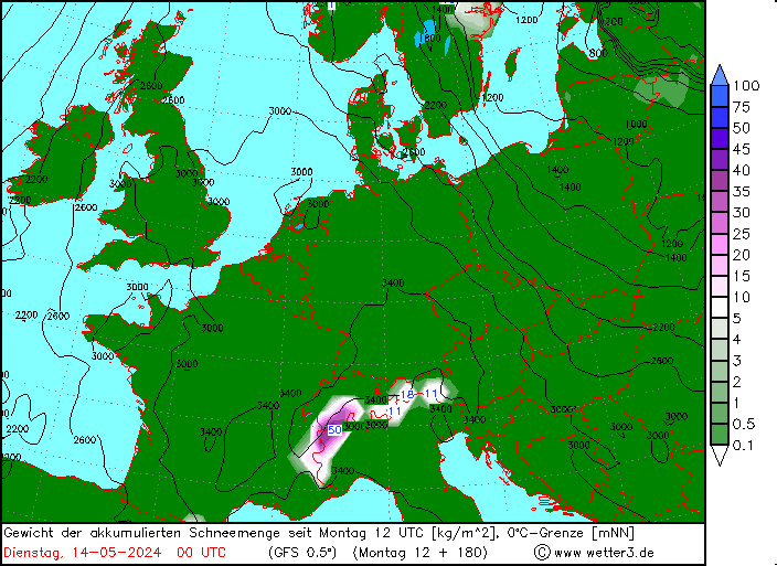
The overnight European model ECMWF run is an absolute snow fest for parts of the Alps for the middle of next week with a low pressure system moving from the Uk, across France and then across to Northern Italy. The GFS run doesn't agree with this though so will be interesting to see which model is closer to the outcome when the time comes.
*** Edit *** Beat me to it "nozawaonsen". That second chart you posted is the ECMWF one I was talking about
|
|
|
|
|
|
You'll need to Register first of course.
You'll need to Register first of course.
|
|
|
|
|
|
paulio, WHOAHH! That looks like Armageddon 
|
|
|
|
|
|
|
|
|
|
|
You'll get to see more forums and be part of the best ski club on the net.
You'll get to see more forums and be part of the best ski club on the net.
|
|
|
|
|
|
Predicted snowfall amounts for this weekend do seem to have drifted down a little especially in the western Alps. GFS was coming up with some rather OTT suggestions for Monterosa/Zermatt a few days ago. Which perhaps unsurprisingly are now looking less likely. Bergfex still has over a foot at altitude in the Arlberg over the next couple of days. We'll see soon enough.
The Österreichische Kuratorium für Alpine Sicherheit has put together some statistics for the season so far. The rough trend is for a decrease in on piste accidents and increase in off piste accidents compared to last year. The very different snow fall patterns being a key element.
Winterbilanz 2011/12
- From 01 November 2011 to 28 March 2012 there were 93 fatalities in the Austrian Alps [this includes road accidents].
- 12% less than last year and below the seven year average of 108.
- On-piste 28 died [compared to 48 last year], 17 suffered heart attacks, four died in falls, three hit barriers, two were killed in collisions, one died in an avalanche and one died in an accident with a piste basher.
- The total number killed in avalanches [so primarily off piste] was 16, higher than last year [where exceptionally on three people were killed in avalanches], but below the average for the time period of 18.
Press coverage of the same story by ORF
- Suggests fatal skiing accidents on piste numbered 8, which was half last years total of 16 [not quite sure how that stacks up with the figures above, but I presume it depends how you are counting, and clearly excludes natural causes like cardiac arrests]. And 20% less accidents and injuries.
- Interestingly less use of artificial snow this season is identified as one of the factors in lower accident numbers along with better snow coverage [so presumably less rocks to hit].
|
|
|
|
|
|
snowHeads are a friendly bunch.
snowHeads are a friendly bunch.
|
What do those latest models mean for Scotland next week please nozawaonsen, Im up there on 11th-15th and hoping for some cold weather and possibly some snow, fingers toes legs and arms are crossed !!! 
|
|
|
|
|
|
And love to help out and answer questions and of course, read each other's snow reports.
And love to help out and answer questions and of course, read each other's snow reports.
|
Ricklovesthepowder, it's tricky. The weather in March was exceptionally mild and dry in Scotland. You can see how it compared to normal in this blog entry from the Met Office.
Third warmest March
Obviously the cold blast last week provided a fair amount of fresh snow, but there wasn't much for it to bond with. The warmer weather expected over the next few days will lead to a rapid thaw. It does look like there could be some snow showers mixed with rain in the coming week or two. If it becomes more snow than rain that may allow some limited skiing options. But I'd be thinking more about hiking and whisky if it were me.
Back to the Alps here's some thoughts from SLF.
National avalanche bulletin for Saturday, 7 April 2012
"On Friday night skies will be overcast. From the northwest snowfall will set in, which will persist through the day on Saturday. In southern regions it will be partly cloudy, accompanied by showers. Between the evening of Good Friday and Saturday evening above approximately 2000 m in the western and central parts of the northern flank of the Alps, 10 to 20 cm of snowfall is anticipated, elsewhere 5 to 10 cm of new fallen snow widespread. The snowfall level will drop to 1000 m by evening."
"On Easter Sunday in northern and eastern regions in particular, snowfall is anticipated down to low lying areas. In southern regions it will be rather sunny. A strong velocity northerly wind will be blowing." [SLF]
|
|
|
|
|
|
|
|
nozawaonsen, cheers. To be honest i gave up a long time ago about skiing, hence the location choice of the cottage we have booked!! It would still be great to get some snow falling though but i think that is a little optomistic! Anyway, i will have a great time whether its 20c and sunny, or -5 and blizzards (i hope for the latter). Please could you keep an updated view for Scotland over the next 10 days for me please as i will not have a great signal where i am am staying from Wednesday, so will only be able to check updates every other day or so.
Thanks!!!
P.S. What whisky can you recommend? 
|
|
|
|
|
|
You know it makes sense.
|
|
Ricklovesthepowder, Can't recommend a whisky but if you are staying around Aviemore there is http://www.maltwhiskytrail.com nearby and the Tourist information should have more information on distilleries for you. If you have time on your way up Edradour Distillery is just outside Pitlochry and you also pass Dalwhinnie Distillery. Cairngorm have been doing there best to have some skiing available but it really is only one run and it wouldn't take much to lose it all again. I would suggest you top up with petrol in Perth as the price in Aviemore is at least 5p more a litre
|
|
|
|
|
|
Otherwise you'll just go on seeing the one name:
Otherwise you'll just go on seeing the one name:
|
|
Ricklovesthepowder, second the Edradour distillery if you are in that neck of the woods. Wonderful place, smallest in Scotland but they make some wonderful single malts. Dalwhinnie is dramatic with its location. The whiskey trail over by Glen Livet is definitely worth a visit but maybe just a bit too far from Loch Katrine. Super walks around the lochs at Dalwhinnie or along the Old Military Road. Lots to do around the Rothiemurchis Estate as well.
|
|
|
|
|
|
Poster: A snowHead
|
|
Ricklovesthepowder, I think a Scottish apres thread may be in order! Single malt and a log fire being an excellent way to finish a day in the mountains in Scotland in many months. I'm rather partial to Bowmore as it happens not that you'll be up that way. Some colder temperatures looking possible in Scotland next week, not convinced it will bring enough snow to kick start things again...
|
|
|
|
|
|
Obviously A snowHead isn't a real person
Obviously A snowHead isn't a real person
|
|
Cold and snowing in the Arlberg this morning. Happy Easter!
|
|
|
|
|
|
Well, the person's real but it's just a made up name, see?
Well, the person's real but it's just a made up name, see?
|
| nozawaonsen wrote: |
| Ricklovesthepowder, I think a Scottish apres thread may be in order! Single malt and a log fire being an excellent way to finish a day in the mountains in Scotland in many months. I'm rather partial to Bowmore as it happens not that you'll be up that way. Some colder temperatures looking possible in Scotland next week, not convinced it will bring enough snow to kick start things again... |
Quite frankly i would be happy with just a decent dusting over the summits to make things look lovely, Ive ruled out the chance of skiing!!! We are staying inbetween Aberfoyle and Loch Katrine so i will look for a few whisky places near by. Please keep me updated next week, thanks.
|
|
|
|
|
|
You need to Login to know who's really who.
You need to Login to know who's really who.
|
Short term looks likely now that Wednesday will see some substantial snowfall at altitude across much of the Alps, likely arriving as rain before turning to snow above around 1300m+ in the west and 1000m+ in the east. But plenty could change in terms of snow line.
The cool and unsettled theme for April looks like extending with the next push of cold weather seemingly lining up for around 17 April.
So March in April and April in March.
|
|
|
|
|
|
Anyway, snowHeads is much more fun if you do.
Anyway, snowHeads is much more fun if you do.
|
Plenty more snow heading for higher parts I'd the Alps. 20-40cm over night tonight (in the west) and tomorrow. Before that some sunny and hot weather especially in the east.
Clearing up Thursday. Then this weekend some more unsettled weather and snow possibly down to 1500m.
|
|
|
|
|
|
You'll need to Register first of course.
You'll need to Register first of course.
|
Just another normal April then..... 
|
|
|
|
|
|
|
|
norris, after last April quite a change. I think certainly up till the half way point this one will look cooler and wetter than normal for much of the Alps.
Anyway last two days have been terrific and continuing the see saw theme back to winter tomorrow.
Here's this evening's SLF for Switzerland.
Fresh snow causing widespread considerable avalanche danger
"Short-term development
On Tuesday evening, precipitation will arrive from the west and south. It will move eastwards on Wednesday. From Tuesday evening until Wednesday evening, 20 to 40 cm of snow will fall, and even as much as 50 cm in some localities, in the Vaud Alps, western Lower Valais, the western part of the main Alpine ridge and in the Gotthard region, and on the southern flank of the Alps and in central Grisons and Engadine. Elsewhere, 10 to 20 cm of snow will fall. The snowfall level will drop, from 2200 m in the west and 1500 m in the south, to approximately 1000 m. During the day, the wind direction will change to northerly. It will be moderate at high altitude and strong in the south. The fresh snow in particular will be transported."
|
|
|
|
|
|
|
|
nozawaonsen,
I would like to thank you for your perfect timing and delivery of the required weather this season. I went to Val Thorens the week before Christmas when you had arranged a huge dump of snow followed by decentish weather, whilst just beforehand the Daily Mail and it's readers were announcing the end of skiing in the Alps and telling the 'smart punter' to fly to the barren slopes of the USA.
We are also going back to VT next week and despite the predictions from others of slush and brown fields, you have arranged for the return of winter.
One question. What weeks should I book for next season?
|
|
|
|
|
|
You'll get to see more forums and be part of the best ski club on the net.
You'll get to see more forums and be part of the best ski club on the net.
|
Good timing indeed! Getting very excited as we've booked flights to Geneva on Thursday evening. Now just need to work out if the snow in Tignes is going to be significantly better than (the easier and cheaper to get to) Chamonix.
Any wonderful insights out there?
|
|
|
|
|
|
|
|
|
Cant help you with debate between Chamonix and Tignes... but can say that using that old invaluable method of looking out of the window, it is snowing hard at 1450m in Les Masses with all trees and surfaces covered. There is about 8cm of fresh snow sitting on our garden table which was not there at 5.30 am - so snowing at about 4cm per hour at the moment.... Was planning on working today but plans are altering...
|
|
|
|
|
|
snowHeads are a friendly bunch.
snowHeads are a friendly bunch.
|
|
The out-of-the-window technique chez paulio this morning reveals a good helping of snow down to about 1500, and a decent dusty frosting down to probably about 1000.
|
|
|
|
|
|
And love to help out and answer questions and of course, read each other's snow reports.
And love to help out and answer questions and of course, read each other's snow reports.
|
15cm at resort level.
Rain yesterday which will have fallen as snow up top.
Bon ski everyone

|
|
|
|
|
|
|
|
|
doorman_tom, go look at steve angus' Val D'Isere thread.
|
|
|
|
|
|
You know it makes sense.
|
|
shoogly, thanks, I have! Looks like winter really is back. Question is: is winter back in Cham too which doesn't involve getting into resort at 2am and a £200 car hire?
|
|
|
|
|
|
Otherwise you'll just go on seeing the one name:
Otherwise you'll just go on seeing the one name:
|
|
Plenty of fresh snow overnight in the Lake Geneva area on the mountains above about 900 to 1000m I'd guess.
|
|
|
|
|
|
Poster: A snowHead
|
looks like 3 days of claggy, wet and rather miserable weather coming up for most of the alpine ridge.
Some fresh flakes up high up hopefully
|
|
|
|
|
|
Obviously A snowHead isn't a real person
Obviously A snowHead isn't a real person
|
A slight pause in the rhythm of cold and snowy followed by warm and sunny weather.
Heavy cloud and light snow falling steadily in the Arlberg at present (settling just above 10-20m St Anton). This looks like continuing on and off over next few days possibly strengthening Sunday/Monday.
Cold again and clearer come Tuesday 17 April. And currently looking like heavier snow fall and below average temperatures around 19/20 April.
So April continues to be a generally cooler than average (albeit hot when the sun breaks through) and unsettled month. And currently setting things up nicely for end of season spring shenanigans in the likes of Espace Killy, Val Thorens and Ischgl.
|
|
|
|
|
|
Well, the person's real but it's just a made up name, see?
Well, the person's real but it's just a made up name, see?
|
Could be a fair amount of snow at altitude over this weekend paricularly in the western Alps and then again around 19/20 April. Wintery temperatures on 17 and possibly clearer weather coinciding with this on Tuesday.
Here's some extracts from SLF for Saturday.
Considerable avalanche danger in some regions
"Between Tuesday and Friday, most snowfall fell in the western part of the northern flank of the Alps and in western Lower Valais, as well as on the southern flank of the Alps from the southern Simplon region into the Bernina region, bringing 30 to 50 cm. In the remaining regions, the amounts of fresh fallen snow were highly varied, most often between 10 and 30 cm."
"On Saturday it will be heavily overcast far and wide. Intermittent snowfall is anticipated."
"On both days it will be heavily overcast in general. On Sunday, snowfall is anticipated in the southern Valais and on the southern flank of the Alps more than anywhere else. On Monday, snowfall is expected widespread."
Sadly a ski instructor was killed yesterday in the Pitztal when an avalanche (possibly triggered by his colleague?) took him over a 300m cliff band.
|
|
|
|
|
|
You need to Login to know who's really who.
You need to Login to know who's really who.
|
I never thought I'd find myself saying this but
WHATS WITH ALL THIS SNOW?!?!?
We are winding down for the season, everythings closing, people are all going home or have already left.
We sunbathed in March and rode powder in April
Stupid poo-poo.
|
|
|
|
|
|
Anyway, snowHeads is much more fun if you do.
Anyway, snowHeads is much more fun if you do.
|
Theres another three weeks of the season left yet and its just approaching its best.
The next two weeks are looking cool and unsettled. Should be further buildup at alltitude.
|
|
|
|
|
|
You'll need to Register first of course.
You'll need to Register first of course.
|
Here's a good (slightly dated) blog from Wasatch Weather Weenies showing how different parts of the Western US faired this season. Showing the stark comparison between conditions in the Pacific North West (which as expected did well out if La Nina) and the South West which compared to normal had a much worse year. Check out the mid March picture of Mount Baker!
Snowpack SWE
|
|
|
|
|
|
|
|
12z GFS keeps the coming week pretty snowy at altitude and even down to low levels at times. Keeping in mind that this is only a rough guide you could see up to a metre of fresh snow falling across large parts of the Alps in the next week (as well as fresh snow in Scotland too).
Of course that is all very subject to change. That said what might actually be good at some stage soon would be some sunshine to enjoy it all in! Monday (in the west) and Tuesday look best for this at the moment.
|
|
|
|
|
|
|
|
Here are some extracts from this evening's SLF update.
Escalating avalanche danger in some regions due to snowfall and wind
"On Sunday there will be heavy cloud cover far and wide. In western and southern regions to begin with, subsequently also in eastern regions, precipitation is anticipated. In southern Valais 20 to 40 cm of snowfall is expected by Sunday evening; in northern Valais, in the western part of the northern flank of the Alps and in Ticino, 10 to 20 cm of new fallen snow is expected, from place to place as much as 30 cm."
"The snowfall level will be approximately 1400 m. The wind will intensify significantly..."
"Trend for Monday and Tuesday
On Monday it will be heavily overcast. Widespread precipitation is expected, particularly on the northern flank of the Alps. The avalanche danger will increase from region to region. On Monday night, skies will be partly clear; during the day on Tuesday it will be rather sunny." [SLF]
|
|
|
|
|
|
You'll get to see more forums and be part of the best ski club on the net.
You'll get to see more forums and be part of the best ski club on the net.
|
|
|
|
|
|
That broad pattern for the Alps still looks to be in place on GFS this morning.
- Periods of quite substantial snowfall at altitude over the next week with temperatures below average for much of the time.
- Switching to high pressure dominated, much milder and clearer weather from Wednesday 25 April.
The switch is pretty much at the break down from hi res to lo res so should start coming into clearer definition in the next few days.
|
|
|
|
|
|
|
|