 Poster: A snowHead
|
|
|
|
 Obviously A snowHead isn't a real person
|
| Snow Hound wrote: |
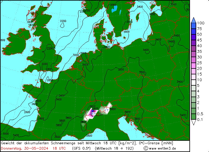
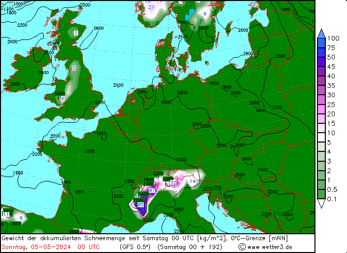
| My mate keeps sending me charts that he says could mean travel chaos in the UK late Jan early Feb? We fly LGW to INN on the 27th. I realise this is outside of any reliable time frame but he's convinced enough to have prepped the Touran just incase we need it. |
I did put this out there over a week ago now but got no response. This is looking fairly likely now amiright? Even John Ketley is on board.
|
|

|
|
|
|
 Well, the person's real but it's just a made up name, see?
|
|
|
|
 You need to Login to know who's really who.
|
@Snow Hound, this is the likely impact of the SSW earlier this year. If you go back through the thread you can see it being discussed a while back.
The SSW increased the likelihood (though not the certainty) of cold weather across Europe. This is now being clearly modelled across most output, with some occasional extreme options being produced.
Whether that leads to any “travel chaos” in the UK is still a moot point, but it certainly looks colder at present.
|
|

|
|
|
|
 Anyway, snowHeads is much more fun if you do.
|
@nozawaonsen,
extreme

cue panic buying of milk & bread. It will be like a mini brexit. no doubt us* older lot will show the younger lot how we used to do it back in the day.
* not a single snowflake showing for my town though!
|
|

|
|
|
|
 You'll need to Register first of course.
|
Breakdown of initial snow records in Austria as recorded by ZAMG (I suspect this will be updated).
https://www.zamg.ac.at/cms/de/klima/news/stellenweise-neuschneerekorde
Following places set new records for 15 days of snow.
Seefeld (T) 283 cm (Rekord)
Kufstein (T) 168 cm (Rekord)
Hochfilzen (T) 451 cm (Rekord)
Lofer (S) 263 cm (Rekord)
Abtenau (S) 240 cm (Rekord)
I drove through Lofer early today. Quite a few roads still closed due to avalanche risk and lots of roadside work clearing damaged trees. On the mountain there were quite a few trees down in the forests and quite a lot of clearance alongside lift lines. And a lot of people working to clear snow off roofs.
|
|

|
|
|
|
|
|
|
@Mr.Egg, what exactly is that meant to be showing and for when, it seems some of the information is cropped?
|
|

|
|
|
|
|
|
Nice wee fall in madonna di campiglio today. 
|
|

|
|
|
|
 You'll get to see more forums and be part of the best ski club on the net.
|
| Mr.Egg wrote: |
@nozawaonsen,
extreme

cue panic buying of milk & bread. It will be like a mini brexit. no doubt us* older lot will show the younger lot how we used to do it back in the day.
* not a single snowflake showing for my town though! |
There is no way that is real
|
|

|
|
|
|
|
|
In terms of North/South - how do we classify the 3 valleys?
It’s kind off middle? Lol.
I’m going at the end of next week - I suspect it’s the south 
|
|

|
|
|
|
 snowHeads are a friendly bunch.
|
Alpe d'Huez is often used as the dividing line between the northern and southern French Alps. Which puts the 3 Valleys in the northern half.
But wherever it is, conditions there are pretty good at the moment!
|
|

|
|
|
|
 And love to help out and answer questions and of course, read each other's snow reports.
|
| Mr.Egg wrote: |
@nozawaonsen,
extreme

cue panic buying of milk & bread. It will be like a mini brexit. no doubt us* older lot will show the younger lot how we used to do it back in the day.
* not a single snowflake showing for my town though! |
Is that cm???
|
|

|
|
|
|
|
|
Fresh snow across the whole of the Alps and Pyrenees next Wednesday and Thursday if 18z has its way.

|
|

|
|
|
|
 You know it makes sense.
|
18z would draw some pretty cold temperatures from the east into the UK, -10 to -12C below average for the time of year by 26 January. But gauging easterlies for the UK is always a bit dicey.
Meanwhile 18z would deliver quite a bit of fresh snow. And er... Austria would do quite well out of it...

|
|

|
|
|
|
 Otherwise you'll just go on seeing the one name:
|
| Minion1980 wrote: |
| @Mr.Egg, what exactly is that meant to be showing and for when, it seems some of the information is cropped? |
Accumalted snow depth last week on january! was 6am run yesterday. 12pm a bit less, 6pm even less 12am less again. So see what todays runs bring!
Last edited by Otherwise you'll just go on seeing the one name: on Fri 18-01-19 7:56; edited 1 time in total
|
|

|
|
|
|
 Poster: A snowHead
|
|
Monthly prognosis from EC confirms the development spoken earlier about. Dry and cold in Northern Europe. Lows south on the continent. Snow for the southern and western parts of the alps and cold weather for a sustained period. Looks increasingly likely that will be a persistent weather regime for a long period (up to 4 weeks).
|
|

|
|
|
|
 Obviously A snowHead isn't a real person
|
The SE picking up the lion’s share in the 00z GFS.
Kärnten would do well if it played out that way.

As I’ve mentioned lots of times don’t take the figures too seriously and anticipate these charts to shift around, but it gives you a feel for the current trend.
|
|

|
|
|
|
 Well, the person's real but it's just a made up name, see?
|
|
What in recent trends is the explanation for expected dry weather?
|
|

|
|
|
|
 You need to Login to know who's really who.
|
| nozawaonsen wrote: |
Breakdown of initial snow records in Austria as recorded by ZAMG (I suspect this will be updated).
https://www.zamg.ac.at/cms/de/klima/news/stellenweise-neuschneerekorde
Following places set new records for 15 days of snow.
Seefeld (T) 283 cm (Rekord)
Kufstein (T) 168 cm (Rekord)
Hochfilzen (T) 451 cm (Rekord)
Lofer (S) 263 cm (Rekord)
Abtenau (S) 240 cm (Rekord)
I drove through Lofer early today. Quite a few roads still closed due to avalanche risk and lots of roadside work clearing damaged trees. On the mountain there were quite a few trees down in the forests and quite a lot of clearance alongside lift lines. And a lot of people working to clear snow off roofs. |
That's crazy for Lofer, at 600m!
They must also be thinking about the highwater season in June. I was kayaking there a few months after the big floods in 2012 - bits of road and bridge were stuck in the river just downstream of Lofer (in the Teufelschlucht). Lets hope for a long stable thaw in spring without big rain events!
|
|

|
|
|
|
 Anyway, snowHeads is much more fun if you do.
|
Another few cms overnight for the Northern French Alps. Still unskiable in the woods below 1300 meters but good down to 1100m where it is open. Maybe a bit more snow around the 22/23 which should also break into the Southern Alps. There is around 50cm on the ground at 1500 meters now.

|
|

|
|
|
|
 You'll need to Register first of course.
|
| davidof wrote: |
| ....Maybe a bit more snow around the 22/23 which should also break into the Southern Alps...... |
This is what is currently (though can all change) on the cards for next week.
A classic Genoa Low or Retour D'Est

|
|

|
|
|
|
|
|
| Weathercam wrote: |
| davidof wrote: |
| ....Maybe a bit more snow around the 22/23 which should also break into the Southern Alps...... |
This is what is currently (though can all change) on the cards for next week.
A classic Genoa Low or Retour D'Est
|
ah good news for the Sudistes.
|
|

|
|
|
|
|
|
|
3b meteo predicting a white out for Madonna di Campiglio fo the week I'm away on the 27th. FI I know, but after 5 years of week long sunshine while skiing that will be a bit of a shock. Its moving around because last night it was showing hitting next week.
|
|

|
|
|
|
 You'll get to see more forums and be part of the best ski club on the net.
|
| denfinella wrote: |
Alpe d'Huez is often used as the dividing line between the northern and southern French Alps. Which puts the 3 Valleys in the northern half.
But wherever it is, conditions there are pretty good at the moment! |
Alpe d'Huez is in the Northern Alps.
|
|

|
|
|
|
|
|
@davidof, according to who?  I'm not sure there's a black and white answer, which is why I just said "often used as the dividing line". Either way, it doesn't change the answer to the original question, which was asking which part the 3 Valleys are in. I'm not sure there's a black and white answer, which is why I just said "often used as the dividing line". Either way, it doesn't change the answer to the original question, which was asking which part the 3 Valleys are in.
The Col du Lauteret is another possible boundary, but Alpe d'Huez and the Oisans region in general which is (meteorologically) to the north of the col often misses out on heavy snow in northerly storms.
--
On the subject of the weather forecast, cold temperatures along with low pressure moving through the Mediterranean are still very much on the cards for next week, which in this case could bring heavy snow for parts of the southern(-eastern) Alps in particular.
|
|

|
|
|
|
 snowHeads are a friendly bunch.
|
| Weathercam wrote: |
| davidof wrote: |
| ....Maybe a bit more snow around the 22/23 which should also break into the Southern Alps...... |
This is what is currently (though can all change) on the cards for next week.
A classic Genoa Low or Retour D'Est
|
I would have thought that a Genoa low would benefit Bormio but not much evidence of it on the latest Bergfex forecast. We're not going out for another 4 weeks so plenty of time yet but given they haven't had much this year anything would be welcome.
|
|

|
|
|
|
 And love to help out and answer questions and of course, read each other's snow reports.
|
| denfinella wrote: |
@davidof, according to who? 
--
On the subject of the weather forecast, cold temperatures along with low pressure moving through the Mediterranean are still very much on the cards for next week, which in this case could bring heavy snow for parts of the southern(-eastern) Alps in particular. |
Not on the latest 6z GFS operational run it doesn't!!. Most of the snow bypasses the southern alps. However we are still 5 days away from the 23rd so plenty of time for things to change!!
|
|

|
|
|
|
|
|
| Gaza wrote: |
| Weathercam wrote: |
| davidof wrote: |
| ....Maybe a bit more snow around the 22/23 which should also break into the Southern Alps...... |
|
I would have thought that a Genoa low would benefit Bormio but not much evidence of it on the latest Bergfex forecast. We're not going out for another 4 weeks so plenty of time yet but given they haven't had much this year anything would be welcome.
|
Think bergfex uses the ECMWF forecast charts. The latest overnight ECMWF run (as well as the latest 6Z GFS run) doesnt show the low pressure in the mediteraanean affecting the Southern Alps much. Every run seems to change the positioning and orientation of the low. Likely wont know for certain what will actually happen until late Sunday/Monday at the earliest
|
|

|
|
|
|
 You know it makes sense.
|
| davidof wrote: |
| denfinella wrote: |
Alpe d'Huez is often used as the dividing line between the northern and southern French Alps. Which puts the 3 Valleys in the northern half.
But wherever it is, conditions there are pretty good at the moment! |
Alpe d'Huez is in the Northern Alps. |
Of course you're right, but isn't there a difference between the Northern/Southern alps distinction in general, with the alpine ridge as the divide and France on the Northern side, and Northern and Southern French alps, albeit without the same clear divide? At least in the context of different weather hitting the more Northerly French resorts than those further South? Usually weather systems on a macro scale seem to hit one or other side of the ridge, making the general distinction the important one, but when there's a significant difference between Northern and Southern French resorts it can be useful to classify as such, even though both are in the Northern alps.
I realise different French resorts have had varying amounts of snow recently, but there does seem to be a distinct difference between the lack of snow most French resorts South of Alpe d'Huez have experienced and the greater amounts the more northerly ones have had. If one were to make a distinction to describe this Alpe d'Huez seems like a reasonable place, albeit without there being a clear divide.
I think that's all they was implied, rather than implying Alpe d'Huez is the border between North and South alps in general. Though of course I may be wrong.
Last edited by You know it makes sense. on Fri 18-01-19 16:45; edited 1 time in total
|
|

|
|
|
|
 Otherwise you'll just go on seeing the one name:
|
@Drogue, yes, I was indeed referring to the boundary between the northern and southern French Alps.
@jimmybog, apologies, think the 6Z was late to update and I must have been looking at the 12Z. Incidentally, what link do you use to see GFS runs? Wetterzentrale's 6Z charts haven't been updated since Wednesday, so I was using the Snowforecast maps (which I think interpret the GFS op run).
You're right that it's still a long way off and we'll need to wait a bit longer for things to firm up!
|
|

|
|
|
|
 Poster: A snowHead
|
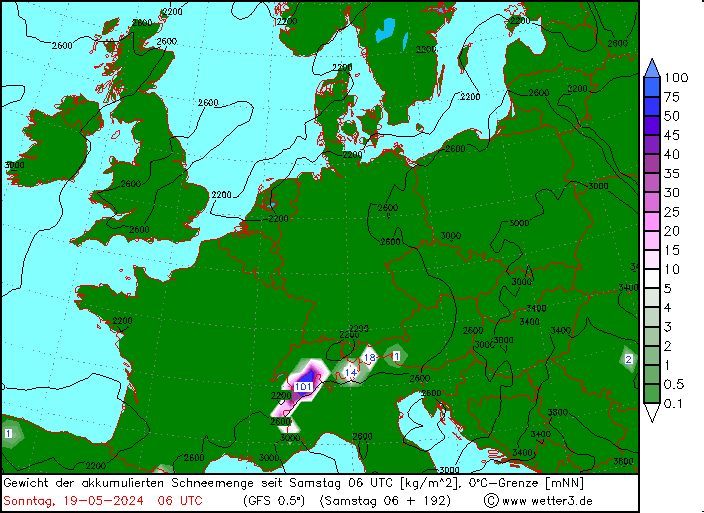
06z GFS

|
|

|
|
|
|
 Obviously A snowHead isn't a real person
|
| denfinella wrote: |
@Drogue, yes, I was indeed referring to the boundary between the northern and southern French Alps.
@jimmybog, apologies, think the 6Z was late to update and I must have been looking at the 12Z. Incidentally, what link do you use to see GFS runs? Wetterzentrale's 6Z charts haven't been updated since Wednesday, so I was using the Snowforecast maps (which I think interpret the GFS op run).
You're right that it's still a long way off and we'll need to wait a bit longer for things to firm up! |
No need for apologies!! I wasn't complaining about anything. It was just an update really from the latest model run.
I still use WETTERZENTRALE.
try the following link but make sure you press F5 to refresh to get the latest charts!!
http://www.wetterzentrale.de/en/topkarten.php?model=gfs&time=3&lid=OP
|
|

|
|
|
|
 Well, the person's real but it's just a made up name, see?
|
| denfinella wrote: |
@davidof, according to who?  I'm not sure there's a black and white answer, which is why I just said "often used as I'm not sure there's a black and white answer, which is why I just said "often used as |
Why is Alpe d'Huez in the Northern French Alps - well because the valley leading into the area starts in the plains in front of Lyon, so that weather systems travelling in from the Atlantic travel up the Romanche valley, dropping snow before being blocked by the Col du Lauteret and Col de la Croix Haute. Contrary to what you suggest, there is very widespread agreement where the Northern Alps and Southern Alps are. The Tarentaise valleys begin at the same point as the Romanche.
Somewhere like Serre Chevalier is in the Southern Alps, at the end of a very long valley starting near Marseille. There is a ridge starting at the border near Montgenevre, passing via the Col du Lauteret, south of les Deux Alpes then to the Col de la Croix Haute and finishing in the Vercors near Valance.
|
|

|
|
|
|
 You need to Login to know who's really who.
|
https://longrangesnowcenter.blogspot.com/2019/01/europe-on-long-term-jan-19th.html
An extract from my latest long range outlook below.
"My overall view is that from the last week of Jan to the second week of Feb, will feature major snow risks for the Southern Alps and the UK. There will be plenty of cold around, but not so much snow for the Northern Alps. We should see a neutralisation in the later stages of the month."
|
|

|
|
|
|
 Anyway, snowHeads is much more fun if you do.
|
@davidof, can't argue with your reasoning from a topography / watershed point of view.
I don't agree with your assertion that there's "widespread agreement" over where the northern and southern (N.B French Alps) boundary is. There are a number of other reasons why it makes sense to put Alpe d'Huez roughly on the border between the two, and a number of meteorological and skiing sources which do exactly this. And even some which put Alpe d'Huez in the southern Alps. Anyway, we're only talking about a difference of a few miles, so does it really matter?!
I'm not going to continue the discussion here though as it's not really on-topic for this thread.
|
|

|
|
|
|
 You'll need to Register first of course.
|
@davidof, +1
The actual Hautes Alpes Department and Provence-Alpes-Côte d'Azur Region starts a few km just below La Grave but for all intensive purposes regarding weather then the Lautaret is the dividing line and you can get amazing weather fluctuations either side.
Loads of discrepancies about next week http://www.meteociel.fr/tendances/1900/la_salle_les_alpes.htm only predicting 8cm or so and then we usually only expect half of what they forecast 
|
|

|
|
|
|
|
|
|
The upper levels look very convoluted next week on all guidance. I expect the charts to shift around even more than usual. Precipitation forecasts will be especially changeable. That 06z GFS chart, for example, should be treated with a lot of suspicion until the nearer term and/or the establishment of inter-model support. Nearly all options are still on the table. The only thing that looks likely is there will probably be precipitation somewhere in western Europe next week.
|
|

|
|
|
|
|
|
What’s on the horizon for the 3 Valleys?
I’m heading out on the 26th Jan. Hoping for a top up for the pistes next week and then some settled weather the week we are there!
And I’ve seen a couple of mentions about the UK getting it pretty bad about then as well. How are we looking for that?
(Before being pointed out, aware that weather changes dramatically and quickly, so nothing is gauranteed!)
|
|

|
|
|
|
 You'll get to see more forums and be part of the best ski club on the net.
|
MeteoAlps also just put one of those graphics showing it will be brass monkies next week. Bound to be really, as I arrive in the GM on Thursday 24th, 3rd ladies ski trip in a row that brings biblical weather 
|
|

|
|
|
|
|
|
| Fridge03 wrote: |
What’s on the horizon for the 3 Valleys?
I’m heading out on the 26th Jan. Hoping for a top up for the pistes next week and then some settled weather the week we are there!
And I’ve seen a couple of mentions about the UK getting it pretty bad about then as well. How are we looking for that?
(Before being pointed out, aware that weather changes dramatically and quickly, so nothing is gauranteed!) |
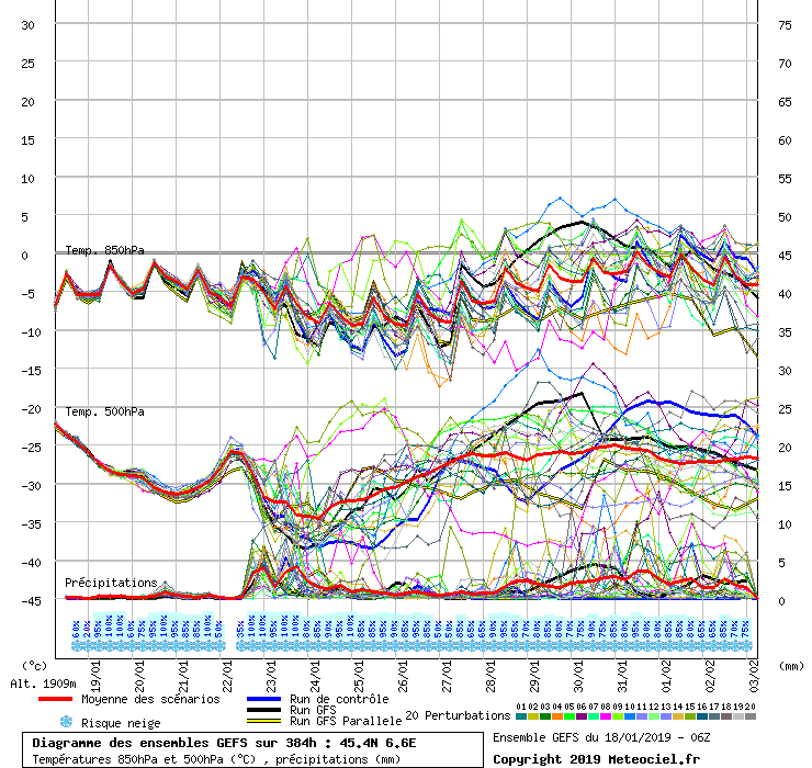
Looks to be cold next week, with reasonable snowfall next Tues/Wed having had consistent support in the GFS for the last couple of days then tailing off towards the end of the week (I've seen 10-40cm predicted in total, with Noza's map above from the 06z GFS seeming to suggest ~20cm). Looks like unsettled but warmer weather most likely for the week you're there, though of course that's off in FI so could all change. Here's the squigglies for around Courchevel at the moment:

|
|

|
|
|
|
|
|

