 Poster: A snowHead
|
| nozawaonsen wrote: |
| rob@rar, And I'd be slightly surprised if you woke to substantial snowfall tomorrow morning. |
About 5 cm of snowfall overnight here in Tignes, not substantial bit still more snow 
It is currently snowing and the snowploughs are busy once again.
|
|

|
|
|
|
Obviously A snowHead isn't a real person
Obviously A snowHead isn't a real person
|
|
Also snowing lightly here in Les Arcs. Not sure if it snowed any more over night - there's so much snow at resort level that a few CMs here or there is no longer noticeable!
|
|
|
|
|
|
Well, the person's real but it's just a made up name, see?
Well, the person's real but it's just a made up name, see?
|
|
yep, started again sometime in the night, snowing still. Don't know how much - haven't been out. 5 cms sounds about right. Guessing at about 20 cms altogether yesterday. Off on the first lift today to show some visiting snowboarders something of the area; looks like they'll not see a lot today but they are gagging to get going, after driving in so much snow, so slowly, yesterday, in chains for the last hour.
|
|
|
|
|
|
You need to Login to know who's really who.
You need to Login to know who's really who.
|
|
|
|
Anyway, snowHeads is much more fun if you do.
Anyway, snowHeads is much more fun if you do.
|
| Samerberg Sue wrote: |
| One of the reasons you have such an EXTREME storm is global warming! |
Yeah right! It's bloody freezing here!
|
|
|
|
|
|
You'll need to Register first of course.
You'll need to Register first of course.
|
Tirol avalanche update.
Critical avalanche situation: high avalanche danger in some western regions!
- "Over the last 24 hours there has been heavy snowfall in places: in the Arlberg region, 30 to 50 cm; in the Silvretta, 30 to 40 cm; in Ausserfern and the Northern Alps, up to 30 cm."
- "... further precipitation extending well into the day on Friday, amidst slightly higher temperatures."
WRF suggests light snow may continue in the west on and off during the day, it looks stronger later this afternoon/evening, but the strongest snow over the next couple of days looks to be in the eastern Alps.
Accumulated snowfall by noon on Friday.

Last edited by You'll need to Register first of course. on Wed 21-12-11 10:02; edited 1 time in total
|
|
|
|
|
|
|
|
Having watched the very dry start to the (pre) season the dancing has worked, i am feeling much better, even though not going until end of Jan.
This is a very low brow question for such a brilliant and riveting thread. Nozawaonsen when you refer to N/S/E/W Alps where are you referring to?
(now before the general mocking begins I am not looking for a line of demarcation on the road, just a general idea) I am going to Westendorf in Tyrol and am wondering where is that in in relation to your predictions? Thanks.
|
|
|
|
|
|
|
|
|
wakkitt, East
|
|
|
|
|
|
You'll get to see more forums and be part of the best ski club on the net.
You'll get to see more forums and be part of the best ski club on the net.
|
wakkitt, as Frosty the Snowman, says Westendorf is in the Eastern Alps. Roughly speaking you can divide west and east along a line from Lake Bodensee (Constance) down to Lake Como.
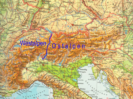
To slightly confuse matters Westendorf is in the west of Austria, but the east of Tirol.
|
|
|
|
|
|
|
|
Thanks very much for the info.
Now if we could only discuss the specific area and dates that I am going, that would be great
|
|
|
|
|
|
snowHeads are a friendly bunch.
snowHeads are a friendly bunch.
|
It does look like snow may be fading out of the Western Alps in the next 24 hours (although in the eastern Alps it looks like strengthening).
Tomorrow looks clearer in the west, especially higher up, with Friday better still (slightly milder than recently too). And with the snowfall of late it should be a smashing day (albeit avalanche risk is likely to be considerable in many places). Further snow in the Eastern Alps on Christmas Eve and temperatures dropping up until Boxing Day when there could be quite a steep rise.
Currently a number of runs then start to take it cooler from 28 December and potentially quite cool again towards the end of the month.

But there is quite a bit of uncertainty this far out (the GFS op runs are mild outliers at present).
What there is broad agreement on is that from Christmas Eve it looks much clearer and much drier than of late.
|
|
|
|
|
|
And love to help out and answer questions and of course, read each other's snow reports.
And love to help out and answer questions and of course, read each other's snow reports.
|
please can someone confirm to me Filzmoos is in the western alps?  or no? or no?
|
|
|
|
|
|
|
|
|
sussexmartlet, No
|
|
|
|
|
|
You know it makes sense.
|
sussexmartlet, it is in the EASTERN Alps speaking continentally and the central part of the Austrian Alps 
|
|
|
|
|
|
Otherwise you'll just go on seeing the one name:
Otherwise you'll just go on seeing the one name:
|
|
thanks all
|
|
|
|
|
|
Poster: A snowHead
|
Dolomites........Snow......needed.......Soon.......help..... 
|
|
|
|
|
|
Obviously A snowHead isn't a real person
Obviously A snowHead isn't a real person
|
2planks, if you are going to the Kronplatz area in the very north - but no one much seems to from the UK - looks like quite a bit of snow today. A dusting for everywhere else there though  GFS shows v light snow around the 30th and then again on the 6th. too far out to be reliable etc etc. We need one of those Genoa lows to whack in from the Med. Fingers crossed and thumbs pressed. GFS shows v light snow around the 30th and then again on the 6th. too far out to be reliable etc etc. We need one of those Genoa lows to whack in from the Med. Fingers crossed and thumbs pressed.
If you can get up to Kronplatz (the valley north of Gardena), pistes are like a dream at the moment according to an Alpinforum contributor yesterday. And further south the Sella Ronda is open and ski club GB describes piste conditions as good
http://www.alpinforum.com/forum/viewtopic.php?f=106&t=41082&start=25
|
|
|
|
|
|
Well, the person's real but it's just a made up name, see?
Well, the person's real but it's just a made up name, see?
|
Strong snowfall continuing through the eastern Alps whilst the west has much clearer weather.
The basic pattern seems set for the coming week with temperatures rising on Friday, dropping back over Christmas, rising again to the 27 December and then falling away towards the end of the month. By and large it looks like it will be clear and sunny (possibly cloudy and in some places, probably further east, snowy on Christmas eve).
Bar the current snowfall and then Christmas Eve looking into next week it looks pretty dry for a while, but with potentially plenty of sunshine.
Tirol avalanche update
Critical avalanche situation continues, amidst high danger regionally
- "Over the last 24 hours there has been renewed heavy snowfall, particularly in the Arlberg/Ausserfern region, the Silvretta and along the Northern Alps, where in the last 2 days there has been a total of 50 to 80 cm of fresh fallen snow."
- 30 to 50cm of new snow anticipated in the Upper Inn Valley by Friday morning
- "Drastic rise in temperature plus solar radiation will keep the avalanche situation tense."
Vorarlberg avalanche update
- 30 cm fresh snow has fallen since yesterday. More than 100 cm in some regions over the last three days.
|
|
|
|
|
|
You need to Login to know who's really who.
You need to Login to know who's really who.
|
Off to Kronplatz on New Year Day -first visit. It seems to have done better and the rest of the area and has made loads of snow to augment. Just seems to have started to snow there now per the webcams. From the GFS I think that will be our lot for a while though and some real rollercoaster temperatures seem expected between now and new year.
Looking forward to it.
|
|
|
|
|
|
Anyway, snowHeads is much more fun if you do.
Anyway, snowHeads is much more fun if you do.
|
|
Blastfromthepast, I'd be interested to hear what it's like there. Often thought of going there myself. Post a report if you get a chance.
|
|
|
|
|
|
You'll need to Register first of course.
You'll need to Register first of course.
|
|
Pjd, thx off to Selva, looks like light snow on the webcams hopefully continue through the night.
|
|
|
|
|
|
|
|
Lots of chat about snow much heavier now temps have risen - spring like 
Interested to know from the experts what the yo-yo temps are likely to do to the snow conditions on piste over the next week, before we arrive in Morzine on the 30th
Does the freeze/thaw cycle help dry out the snow or harden it up.
OH won't be happy if it's icy.
|
|
|
|
|
|
|
|
There is a week of sun on the way to the European Alps.
It is going to be icy in most resorts below midstation by New Year's Eve.
|
|
|
|
|
|
You'll get to see more forums and be part of the best ski club on the net.
You'll get to see more forums and be part of the best ski club on the net.
|
|
It's not going to warm up that much and only for a few days according to the wiggles , so for the people there now and next week, sure they will get he best conditions, and even if you add in the increased traffic I thinks it s to quick to assume conditions will be icy all round, what with the pisteurs skill and artificial snow making, I,m mean in France last year they did miracles with the little snow they had ,conditions were not great but I found plenty of grippy snow when I went in feb
|
|
|
|
|
|
|
|
rising temps is not a problem when they are rising from -15ºC.
start worrying if you reports of extended temps over freezing.
|
|
|
|
|
|
snowHeads are a friendly bunch.
snowHeads are a friendly bunch.
|
|
Warm and sunny and magnificent today. Froze hard overnight, with clear skies, but about 9 degrees (shade temperature) on our terrace at 1550m at midday.
|
|
|
|
|
|
And love to help out and answer questions and of course, read each other's snow reports.
And love to help out and answer questions and of course, read each other's snow reports.
|
Some awesome conditions over the Alps today with blue skies and plenty of fresh snow. It'll be milder than recently, which won't be unpleasant.
Tomorrow though may see a little... snow. Probably more so in the eastern Alps, but France looks like it might get some early in the day.
Here is WRF at 0600.

Christmas Eve and Christmas Day both look quite cold. The latter should be sunny too!
Boxing Day through to 28 December look warm (unseasonally so) and sunny, possibly some high cloud around. Temperatures though drop sharply on 29 December (possibly accompanied by a very weak band of snow). Currently looks like it could be cold out on New Year's Eve.

FI sees high pressure eventually losing out and offers the potential for further snow around 03 to 05 January (driven by low pressure in the Med in the 06z), but inevitably that is too distant a prospect to have any faith in.
Over in the US, the momentum has yet to really build.
Herb's Ski Weather Forecast
Ski Weather - December 20, 2011
"Nationwide, this is perhaps the most challenging holiday period, in terms of open terrain and overall snow conditions, in the past 25 years. There isn't a region in this country where the slopes are in really outstanding shape, and there are only a handful of resorts anywhere near full operation."
But there are suggestions of an improvement.
Winter Solstice
|
|
|
|
|
|
|
|
|
Serves them right for last year eh...
|
|
|
|
|
|
You know it makes sense.
|
nozawaonsen, " (driven by low pressure in the Med in the 06z)" - didn't somebody say that's what the Dolomites need to get some much needed attention from the snow gods? please say yes, please say yes... 
|
|
|
|
|
|
Otherwise you'll just go on seeing the one name:
Otherwise you'll just go on seeing the one name:
|
|
ishay, yes, that run would have brought snow to the Dolomites, but at that range it could easily disappear from view.
|
|
|
|
|
|
Poster: A snowHead
|
Ooh that would be good. heading to austria on 4th jan some fresh would be nice.
Also seems funny this thread was always at the top of the list, then it snows and very few posts in comparrison
|
|
|
|
|
|
Obviously A snowHead isn't a real person
Obviously A snowHead isn't a real person
|
mattiwilkin,
In a nutshell it snowed ! Fickle lot us snowheads even noza went missing for 24 hours
|
|
|
|
|
|
Well, the person's real but it's just a made up name, see?
Well, the person's real but it's just a made up name, see?
|
Some potentially quite tricky weather coming up for Scotland.
Boxing Day
Wednesday 28 December
And a yellow severe weather warning from the Met Office for rain.
"Persistent and sometimes heavy rain is likely to commence during Christmas Eve. This will continue at times through both Christmas Day and Boxing Day, bringing an increasing risk of localised flooding issues."
|
|
|
|
|
|
You need to Login to know who's really who.
You need to Login to know who's really who.
|
| Quote: |
mattiwilkin,
In a nutshell it snowed ! Fickle lot us snowheads even noza went missing for 24 hours
|
Yes, I was aware that at the first hint of warmer temps, I was mumping my gums about potential ice, sorry everyone.
|
|
|
|
|
|
Anyway, snowHeads is much more fun if you do.
Anyway, snowHeads is much more fun if you do.
|
Looks like tomorrow and Christmas Day will be much colder than today. And some snow.
It looks like it will be arriving in the French Alps early morning, but looks like it will be more persistent in the Eastern Alps. Nevertheless I would be surprised if it was as sunny in the French Alps as it was today, Christmas Day though looks like it will be cold and sunny.
Boxing Day will see daytime temperatures climbing, but with clear skies overnight temperatures will be cold and this pattern looks set to continue up until 29 December. At this point cooler temperatures look like returning once more particularly by 30 December.
At present there is a suggestion that a weak band of snow will pass through on 29 December and on this evening's GFS a slightly stronger one on 30 December. Both of these focussed on the eastern Alps. ECM also looks like it could deliver snow.

But clearly that's still some way off and plenty could change.
Heading out into FI temperatures look like rising with the start of the New Year. Before dropping and offering opportunities for further snow in the second half of the first week. The control run was particularly appealing. But too far for any confidence at all.
Here are some ensembles.
Les Deux Alpes.
Chamonix.
The Arlberg.
Hintertux.
Sestriere.
Folgaria.
Zermatt.
Cairngorm.
Eastern Pyrenees.
Bad Gastein.
|
|
|
|
|
|
You'll need to Register first of course.
You'll need to Register first of course.
|
|
|
|
|
|
|
|
|
|
|
|
|
|
You'll get to see more forums and be part of the best ski club on the net.
You'll get to see more forums and be part of the best ski club on the net.
|
Un début décembre généreux en précipitations sur une grande partie du pays [Meteo France]
A generous amount of rainfall across most of the country in early December
- Above a line from Dax to Grenoble, more rain fell in the first three weeks of December than in the whole three months of Autumn.
- Over much of northern and western France one and half to two times as much fell as in a normal December.
- You have to go back to December 1999, a very rainy, stormy month, to find such substantial rainfall.
- In contrast regions close to the Mediterranean had significant deficits.
12z GFS sticks to its guns over the potential for snow fall at the end of the month, preferring to bring in high pressure. Will see what ECM has to say in a couple of hours.
Should be some great Christmas Day conditions.
Off to find a mince pie in the pub. Happy Christmas.
|
|
|
|
|
|
|
|
|
nozawaonsen, Happy Christmas to you, and a huge thanks for your contribution to our knowledge and enjoyment!
|
|
|
|
|
|
|
|


