 Poster: A snowHead
|
Amazing photo from Stelvio on Facebook yesterday:

|
|

|
|
|
|
 Obviously A snowHead isn't a real person
|
|
@clarky999, cracking pic! are they still open?
|
|

|
|
|
|
 Well, the person's real but it's just a made up name, see?
|
|
|
|
 You need to Login to know who's really who.
|
That's brutal.
Looks like Mick Jagger's face.
|
|

|
|
|
|
 Anyway, snowHeads is much more fun if you do.
|
| Whitegold wrote: |
Australia seeing good snowfall at the moment.
Perisher getting record snow.
|
We have seen big snow years for three years in a row here in Australia.
|
|

|
|
|
|
 You'll need to Register first of course.
|
|
After a fine morning some pretty heavy rain amongst thunderstorms in parts of Austria today particularly Obersteiermark and Murtal.
|
|

|
|
|
|
|
|
|
|
|
|
|
|
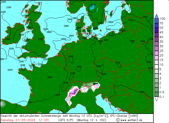
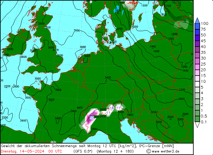
Last few GFS op runs have been suggesting possibility of snow line dropping to around 2000m middle of next week. Wouldn’t last obviously, but might bring some fresh snow to the glaciers...
|
|

|
|
|
|
 You'll get to see more forums and be part of the best ski club on the net.
|
NAO working itself up towards something slightly positive after extended negative spell...
https://www.cpc.ncep.noaa.gov/products/precip/CWlink/pna/nao.sprd2.gif
And some Matt Hugo thoughts on NAO...
“What would be impressive is if, overall, the NAO this winter was -ve. This run through the late spring and summer period has just suddenly bucked the trend of late, it's unlikely to keep going, but if say after a more +ve NAO in autumn it switched again, then that wowzers”
https://twitter.com/matthugo81/status/1166050834280525825?s=21
Keep in mind a strongly -NAO can bring real cold weather to the UK and Northern Europe, but can also cut the snow off from the Alps.
|
|

|
|
|
|
|
|
One of the nice features on meteologix is that we can see ECM freeze level forecasts, so here is their +10 day view on Europe, Sunday 8th Sep (too far to be reliable), but shows the cold air coming down from N / NE.
Temperature rollercoaster next week, with sudden plunge mon-tues, a sharp recovery and second plunge end of the week seen across the main models and ensembles.
At that range I think all we can say is that there is potential for some more northerly cold air to hit the alps next weekend, but no idea where exactly....could shift 1000 miles east, or disappear completely.

ECM 10 day accumulated precipitation.

Here's the GFS view on FL's for Avoriaz over the same period. Note the Op (black) is a cold outlier for next weekend (7-9th), so in my view the average (red) is a better guide at that range. The Op is likely to flip above and below the average over the next few days. Any sustained move by the Op (and control - blue) over several runs / days though would be more revealing.

And just for fun, here's GFS 06z Op snowfall next weekend......pretty sure that's not going to happen, but nice to see that charts lighting up this early.

It's also the beginning of hurricane season, with Dorian currently making the headlines as it points towards florida...adding to the modelling noise across the atlantic in the weeks to come.
Last edited by Ski the Net with snowHeads  on Fri 30-08-19 13:19; edited 1 time in total on Fri 30-08-19 13:19; edited 1 time in total
|
|

|
|
|
|
 snowHeads are a friendly bunch.
|
@polo, There might be a bit of snow on the glaciers I guess. There was some the other week. Otherwise, we're getting a cycle of hot days and wet* days.
*Innsbruck rain. That is, all the rain, at the same time 
|
|

|
|
|
|
 And love to help out and answer questions and of course, read each other's snow reports.
|
|
I am no environ-mentalist but it is staggering just how much snow has disappeared from Stubai Glacier resort this summer. They have none, after having 660cm in June. Fingers crossed for some big autumnal storms.
|
|

|
|
|
|
|
|
|
@Snowsartre, judging by pictures on Instagram the Hintertux is in the same state.
|
|

|
|
|
|
 You know it makes sense.
|
@Bennyboy1, 
|
|

|
|
|
|
 Otherwise you'll just go on seeing the one name:
|
|
|
|
 Poster: A snowHead
|
|
@Snowsartre, I have been in the Ziller for the past week. Locals saying August was colder and wetter than normal. May was cold with late snow. But June and July was very hot. I am sure there are stats to prove/disprove. But like you I am surprised how much melt there has been.
|
|

|
|
|
|
 Obviously A snowHead isn't a real person
|
|
|
|
 Well, the person's real but it's just a made up name, see?
|
| Bennyboy1 wrote: |
| @Snowsartre, I have been in the Ziller for the past week. Locals saying August was colder and wetter than normal. May was cold with late snow. But June and July was very hot. I am sure there are stats to prove/disprove. But like you I am surprised how much melt there has been. |
It has been the same cycle every year since the 1990s, when global boiling took off.
Roasting summers are killing all glaciers in the Northern Hemisphere and Arctic.
Even after a big winter, the boiling summers just melt away the snow and ice.
|
|

|
|
|
|
 You need to Login to know who's really who.
|
|
|
|
 Anyway, snowHeads is much more fun if you do.
|
Sudden intensification of Dorian to one of the strongest hurriances ever recorded, sub 915mb
NOAA
1245pm Update: Hurricane #Dorian has made landfall at Elbow Cay, Abacos. Maximum sustained winds have increased to 185 mph with gusts over 220 mph.

...and it's already on Wikipedia as the joint highest ever @185mph tied with Labor Day 1935
https://en.wikipedia.org/wiki/List_of_Atlantic_hurricane_records
|
|

|
|
|
|
 You'll need to Register first of course.
|
|
|
|
|
|
Definitely feeling pretty autumnall here now! Been snowing at Pitztal this morning, and Bergfex is suggesting around 20cms for Stubai this week.

|
|

|
|
|
|
|
|
@clarky999, quite a shift from summer to autumn! It’s been really grim out east.
More snow to come up high for the end of the week.

|
|

|
|
|
|
 You'll get to see more forums and be part of the best ski club on the net.
|
Still looking good for snowfall beneath 2000m Thursday through to Monday currently looking focussed on eastern Alps.

|
|

|
|
|
|
|
|
|
|
|
 snowHeads are a friendly bunch.
|
| nozawaonsen wrote: |
@clarky999, quite a shift from summer to autumn!
 |
Definitely chill in air this morning at home too, made me think of this thread. I love those first nights when winter is approaching.
|
|

|
|
|
|
 And love to help out and answer questions and of course, read each other's snow reports.
|
Lot's of signals over the last 3-4 days for high pressure to make a comeback next week over France / UK. Any ridges towards Iceland getting flattened by stronger westerlies, and tropical storm remnants joining the jet stream.
Even if we do see the azores high become more amplified, it's too early to expect much troughing over the central alps, (eastern end being favoured of course as it's further from the azores). Hopefully will see the HP blob move further out into the atlantic closer to Nov/Dec to allow more N/NW flow to reach western end. On the other hand if Azores high moves too far west, we get troughing in the bay of biscay and a warm SW flow into the alps. So it's a fine line even under -NAO. I think Nov-mid Dec 2017 was the best example of a good -NAO (for northern alps) in the last 5 years or so.
As for this weekend (or even thurs-mon), 2500m looks to be the average FL across the northern alps now, only dropping to low 2000's briefly on sunday 8th. And maybe again on Tues 10th. So usual performance from the models, GFS/FV3 Op run moves around a lot and over estimates precipitation (being same data that snow-forecast use). UKMO/ECM Ops steadier, more reliable.
Avoriaz and Innsbruck below, can see it's wetter in the east, and also looking cooler week 2 according to mean FL (plus Op and control in this instance)


|
|

|
|
|
|
|
|
|
|
|
 You know it makes sense.
|
Generally cooler than average temperatures for much of the next week over the Alps, warming up at the end of next week and into the weekend before both GFS and ECM plunge us into the cold again (obviously time for that to change, but building up some consistency).

|
|

|
|
|
|
 Otherwise you'll just go on seeing the one name:
|
„Am Wochenende könnte es turbulent werden:
Von Sonntag auf Montag ist unter Umständen mit Neuschnee bis in einige höher gelegene Täler zu rechnen.
Während sich die Schneefallgrenze am Freitag und Samstag meist zwischen 2200 und 2600 m bewegt, bringt ein erneuter Tiefdruckvorstoß am Sonntag noch kältere Luftmassen mit sich. In Kombination mit gebietsweise intensiven Niederschlägen ist ein vorübergehendes Absinken der Schneefallgrenze bis in Mittelgebirgslagen oder sogar bis in Täler um 1000 m möglich. Der Schwerpunkt der Schneefälle ist derzeit noch nicht exakt festzumachen, liegt aber voraussichtlich von den Tuxer / Zillertaler Alpen über die Hohen bis in die Niederen Tauern. Hier können unterhalb der Waldgrenze 20 bis 30 cm Neuschnee und lokal auch mehr zusammenkommen, in Hochlagen auch bis zu einem dreiviertel Meter. Am Montag klingen die Niederschläge wieder ab.“
ZAMG suggesting cold air on Sunday combined with heavy rain could bring the snow line briefly down to 1000m in places in the Austrian Alps. Possibly 20-30cms of snow falling beneath the treeline and up to 75cm at altitude. Snowfall likely focussed around Tux/Zillertal.
|
|

|
|
|
|
 Poster: A snowHead
|
|
|
|
 Obviously A snowHead isn't a real person
|
|
|
|
 Well, the person's real but it's just a made up name, see?
|
Interesting chart on September snowfall in Denver, Colorado, for the past 138 years.
No major Sep snowfall this century, due to global warming.

|
|

|
|
|
|
 You need to Login to know who's really who.
|
Paznauner Taja first thing.
Paznauner Taja a couple of hours later.
|
|

|
|
|
|
 Anyway, snowHeads is much more fun if you do.
|
The web cams at Solden are a joy to see. 
|
|

|
|
|
|
 You'll need to Register first of course.
|
@nozawaonsen, nice!!
Just drove back from Garmisch (good kayaking weather haha) and it was 3°C and snowing to the bottom station at Seefeld. All the mountains are looking pretty white!
Other friends were kayaking *in* the snow in Ötztal (around Vent).
|
|

|
|
|
|
|
|
|
|
|
|
|
I got caught Sat in Typhoon Lingling in South Korea.
Got kinda blowy for a few hours.
Taken 2 days to get a flight out.

|
|

|
|
|
|
 You'll get to see more forums and be part of the best ski club on the net.
|
|
|
|
|
|
@munich_irish, yup. It’s been shrouded in cloud most of the day, but in the gaps I could see snow down to about 1900m. Still got my shorts on, so that’s a bit surreal 
|
|

|
|
|
|
|
|

