Poster: A snowHead
|
|
|
|
Obviously A snowHead isn't a real person
Obviously A snowHead isn't a real person
|
|
seany1, thanks for the link, of course can't remember how to work out what it means
|
|

|
|
|
|
Well, the person's real but it's just a made up name, see?
Well, the person's real but it's just a made up name, see?
|
|
|
|
You need to Login to know who's really who.
You need to Login to know who's really who.
|
|
kitenski, thanks, at least it is 50/50 not the tropical for the next few days
|
|
|
|
|
|
Anyway, snowHeads is much more fun if you do.
Anyway, snowHeads is much more fun if you do.
|
|
|
|
You'll need to Register first of course.
You'll need to Register first of course.
|
| Quote: |
It will probably start feeding in from around now.
|
dead right, nozawaonsen, it's been raining for a while, and as it's 3/4 degrees at 1550m there's nowhere round here it's going to be falling as snow. Let's hope it's cooler for the Sunday Soaking.
|
|
|
|
|
|
|
|
|
|
|
|
|
|
|
|
You'll get to see more forums and be part of the best ski club on the net.
You'll get to see more forums and be part of the best ski club on the net.
|
|
looks like the snow/rain completely missed the Annivers region of Switzerland last night
|
|
|
|
|
|
|
|
kitenski, last night's band was relatively weak and broke up quite a bit as it came in (yesterday morning I thought it wasn't going to make it at all!)
Sunday/Monday's band looks stronger and most likely to be strongest around the French Alps. It looks weaker and less focussed the further east you go. Obviously that could all change and will vary tremendously from valley to valley. Hope you get some snow!
|
|
|
|
|
|
snowHeads are a friendly bunch.
snowHeads are a friendly bunch.
|
|
nozawaonsen, really appreciate this thread....keep up the good work even if its not good weather news all the time...
|
|
|
|
|
|
And love to help out and answer questions and of course, read each other's snow reports.
And love to help out and answer questions and of course, read each other's snow reports.
|
|
here here (or is it hear hear?)
|
|
|
|
|
|
|
|
Nozawaonsen, Thanks too for the thread
Ken
|
|
|
|
|
|
You know it makes sense.
|
kendub, Pyrenees could get snow Sunday evening, Monday morning and again on Tuesday. Looks like it will be more on the French side. It is going to be very warm during the week. Could be quite sunny too past Tuesday. So Spring in January is my best guess!
06Z makes the UK rather snowy around 19 January....
|
|
|
|
|
|
Otherwise you'll just go on seeing the one name:
Otherwise you'll just go on seeing the one name:
|
|
yeah conditions not ideal, very unusual for Jan...the ironic thing is just below freezing here in Dublin
|
|
|
|
|
|
Poster: A snowHead
|
|
|
|
Obviously A snowHead isn't a real person
Obviously A snowHead isn't a real person
|
|
Can you give me the your prediction for Les Deux Alpes please as im thinking of being there from 27th jan for 1 week. Whats the outlook?
|
|
|
|
|
|
Well, the person's real but it's just a made up name, see?
Well, the person's real but it's just a made up name, see?
|
| Ricklovesthepowder wrote: |
| Can you give me the your prediction for Les Deux Alpes please as im thinking of being there from 27th jan for 1 week. Whats the outlook? |
Honestly rick nobody can say so far ahead, given its height and good snow record it's a fairly safe bet IMHO!!!
|
|
|
|
|
|
You need to Login to know who's really who.
You need to Login to know who's really who.
|
The 00z is looking good for a welcome snowfall (chart suggests approx 25cm) down to around 1200m in the Dolomites for late Monday/early Tuesday and then thankfully no rain later in the week:

Keeping my fingers crossed that it comes off!!
|
|
|
|
|
|
Anyway, snowHeads is much more fun if you do.
Anyway, snowHeads is much more fun if you do.
|
Ricklovesthepowder!
kitenski is quite right any sort of prediction that far out would be with pretty low confidence.
I believe the Met Office has 30 day ensembles they use to put together their mid term outlook. But inevitably it is very subject to change.
For what it's worth here is an extract from the current UK 15-30 day outlook.
"... it is expected to become colder from the north across all parts at the end of January and into the start of February. Temperatures are expected to return to near or below average, perhaps well below average at times."
These mid term outlooks were pretty good at spotting the December cold and the Met Office did a good job. But as I said I really don't think I'd have too much confidence at this stage. It does however fit into the overall pattern of a move from the current mild weather from mid month. Whether this holds and if it does how long it will hold for... who knows...
But as kitenski says Les Deux Alpes is in the Alps. It is winter. So go for it... 
Incidentally Met Office advisories are out now for the risk of Heavy Snow in Scotland, NW England, NE England and Northern Ireland for today and tomorrow (flash warnings for Strathclyde, Lothian and Tayside and Fife overnight)...
|
|
|
|
|
|
You'll need to Register first of course.
You'll need to Register first of course.
|
| kitenski wrote: |
| Ricklovesthepowder wrote: |
| Can you give me the your prediction for Les Deux Alpes please as im thinking of being there from 27th jan for 1 week. Whats the outlook? |
Honestly rick nobody can say so far ahead, given its height and good snow record it's a fairly safe bet IMHO!!! |
Yup, agree anywhere that goes as high as L2A is a relatively safe bet although they had quite a lot of rain yesterday up to around 2200 metres so the lower slopes are looking pretty washed out. If that remains the case you'll be able to head high and get decent sliding up there but it could, and doubtless will, all change by the end of the month so it's really far too early to call when it comes to the weather and snow conditions lower down.
| nozawaonsen wrote: |
| Incidentally Met Office advisories are out now for the risk of Heavy Snow in Scotland, NW England, NE England and Northern Ireland for today and tomorrow (flash warnings for Strathclyde, Lothian and Tayside and Fife overnight)... |
Yeah, at the moment Scotland is escaping the warmer stuff that's affecting lower levels in the Alps, conditions are pretty excellent right now with a good amount of fresh on the slopes both in the east and west. However it looks like next week could be dicey although I get the impression the models are undecided on whether we're looking at a return to more average temps (Scotland is still in the very cold Arctic air unlike much of England) or heading towards a more concerted warm up - hopefully it's the later rather than the former! Fingers crossed though for a return to much colder weather after next week though but who knows for certain, certainly not the models that's for sure lol 
|
|
|
|
|
|
|
|
|
|
|
|
|
|
|
|
You'll get to see more forums and be part of the best ski club on the net.
You'll get to see more forums and be part of the best ski club on the net.
|
|
|
|
|
|
|
|
|
snowHeads are a friendly bunch.
snowHeads are a friendly bunch.
|
|
Ricklovesthepowder, if things stay the way they are you will be very, very, glad you chose LDA and not the Portes du Soleil. Worry not! The state of the lower runs really doesn't matter; get up high, then download by lift.
|
|
|
|
|
|
And love to help out and answer questions and of course, read each other's snow reports.
And love to help out and answer questions and of course, read each other's snow reports.
|
|
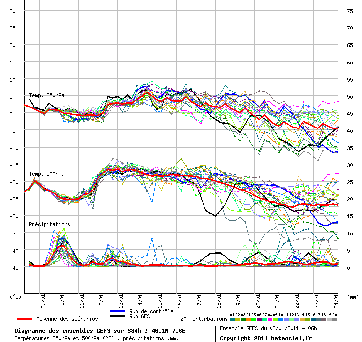
in fact looking at the graph again when the 500 rises faster than the 850 on the 12th jan it's also followed by precipitation. can someone more knowledgable confirm i'm seeing the right pattern?
|
|
|
|
|
|
|
|
rogg, the 850 hPa temperature, being closer to the ground, tends to get a lot more churned up (modified) so the temperature value doesn't change in range as much. Above it, the large lumps of the atmosphere which are being pushed about in a general west to east direction are more immune to that nearer surface mixing as most of the 'weather' is happening below. Looking at a 500 hPa temperature is not normal practice and appears on those charts because it's easy enough to include on the y axis. Normally forecasters would look at the thickness value or 'height' in dam at 500 hPa (1/2 atmosphere, 500 mB, 14.46 inches mercury or whatever unit you want to measure 0.5 atmospheric pressure) i.e how many tens of metres above sea level that the atmosphere can be cut in two by equal mass above and mass below. This tells more than the absolute temperature at a certain pressure because it reveals a total atmospheric density at that point, independent of how much of it there is at that moment or what mixing is going on below. A lower thickness for height = a denser atmosphere and is colder so less thermal energy to give up etc. You'll usually see that high pressure areas at sea level are effectively maintained by warmer air (greater thicknesses) which might appear to be lagging behind the surface high pressure but are in fact just 'behind the scenes' and providing the energy for the surface activity.
The typical height of 500 hPa in the Alps will be somewhat more than 5,000 metres i.e beyond the summit of the heighest of them. So although most of the weather isn't actually happening at 500, low 500 hPa thicknesses will modify the 850 hPa values downwards so that snow is more likely at lower elevations.
Your observation of the higher rise in temperature at 500 hPa on the 12th than its 850 hPa temperature immediately below corresponds with that blob of warm air carried along south of the polar front. A variety of factors can influence how rapidly or how much those temperature values change. e.g. the faster a blob moves, the more rapid the change in temperature value, or the smaller a blob's physical size, the more rapid the change in value for the same speed and the angle of incidence of a blob will make a huge difference i.e. just a glancing blow or a head-on collision.
Last edited by So if you're just off somewhere snowy come back and post a snow report of your own and we'll all love you very much  on Sat 8-01-11 17:14; edited 1 time in total on Sat 8-01-11 17:14; edited 1 time in total
|
|
|
|
|
|
You know it makes sense.
|
moffatross, that's a handy link to get a more customised view, presumably they use software to interlace the raw data from the surrounding GFS ensembles to achieve that level of resolution. I assume that the coordinates need to be expressed in hundredths of a degree rather than degrees and minutes. I'll bookmark it, thanks! 
|
|
|
|
|
|
Otherwise you'll just go on seeing the one name:
Otherwise you'll just go on seeing the one name:
|
kitenski, someone on here gave me the link to the meteograms, it's a format that a layman like me can understand better. Assuming 46N 7.5E are near to Zinal, here is the meteogram chart:
http://www.wzkarten.de/pics/MS_075460_g05.png
You can fiddle with the coordinates in the address. Bear in mind that these particular coordinates are halfway up a mountain somewhere in the Upper Valais (at 2345m, looks like the Stockhorn above Zermatt) you'll have to adjust the temps to allow for the resort being a bit lower.
|
|
|
|
|
|
Poster: A snowHead
|
|
kitenski, looks like if that forecast precipitation arrives on Sunday night, you'll get some fresh snow in resort. Keep your fingers crossed, eh?
|
|
|
|
|
|
Obviously A snowHead isn't a real person
Obviously A snowHead isn't a real person
|
|
|
|
Well, the person's real but it's just a made up name, see?
Well, the person's real but it's just a made up name, see?
|
|
|
|
You need to Login to know who's really who.
You need to Login to know who's really who.
|
|
I don't know is it any good this weather page but have a look and say what you think
|
|
|
|
|
|
Anyway, snowHeads is much more fun if you do.
Anyway, snowHeads is much more fun if you do.
|
| moffatross wrote: |
rogg, the 850 hPa temperature, being closer to the ground, tends to get a lot more churned up (modified) so the temperature value doesn't change in range as much. Above it, the large lumps of the atmosphere which are being pushed about in a general west to east direction are more immune to that nearer surface mixing as most of the 'weather' is happening below. Looking at a 500 hPa temperature is not normal practice and appears on those charts because it's easy enough to include on the y axis. Normally forecasters would look at the thickness value or 'height' in dam at 500 hPa (1/2 atmosphere, 500 mB, 14.46 inches mercury or whatever unit you want to measure 0.5 atmospheric pressure) i.e how many tens of metres above sea level that the atmosphere can be cut in two by equal mass above and mass below. This tells more than the absolute temperature at a certain pressure because it reveals a total atmospheric density at that point, independent of how much of it there is at that moment or what mixing is going on below. A lower thickness for height = a denser atmosphere and is colder so less thermal energy to give up etc. You'll usually see that high pressure areas at sea level are effectively maintained by warmer air (greater thicknesses) which might appear to be lagging behind the surface high pressure but are in fact just 'behind the scenes' and providing the energy for the surface activity.
The typical height of 500 hPa in the Alps will be somewhat more than 5,000 metres i.e beyond the summit of the heighest of them. So although most of the weather isn't actually happening at 500, low 500 hPa thicknesses will modify the 850 hPa values downwards so that snow is more likely at lower elevations.
Your observation of the higher rise in temperature at 500 hPa on the 12th than its 850 hPa temperature immediately below corresponds with that blob of warm air carried along south of the polar front. A variety of factors can influence how rapidly or how much those temperature values change. e.g. the faster a blob moves, the more rapid the change in temperature value, or the smaller a blob's physical size, the more rapid the change in value for the same speed and the angle of incidence of a blob will make a huge difference i.e. just a glancing blow or a head-on collision. |
thanks moffatross. so the precised version of the above is - "no, not really, but you scored a lucky guess on the 12th"  i'll read it through again a few times. i'll read it through again a few times.
Last edited by Anyway, snowHeads is much more fun if you do. on Sat 8-01-11 22:16; edited 1 time in total
|
|
|
|
|
|
You'll need to Register first of course.
You'll need to Register first of course.
|
rogg, sorry I didn't really answer the question and think I might dig myself into a cowd00 (edit - I didn't say cowdoo) hole if I don't stop soon  but I can't stop now so anyway, on the 12th ... but I can't stop now so anyway, on the 12th ...
http://www.wzkarten3.de/pics/Rtavn961.png
... the warm air moving west to east is advancing on colder air and because that warm air is also richer in moisture, when it slides over the colder underneath, there is plenty of preciptation that can condense out as it is cooled down. So with a warm front, yes a rise in temperature at 500 hPa can coincide with rain or snow but similarly as it slides away again, the cold air can fill its retreating flank, making a cold front and more rain/snow again.
With the polar front moving further north than of late and taking a bee-line west to east, no deep lows are expected to dive down into the fray. So it becomes quite complex in the Alps over the next 7 days with a lot of warm high pressure around and nothing on a grand scale to disturb it but just a few little ripples. Warm air advancing on bits of colder air makes for more precipitation than warmer air moving away from colder therefore warm fronts are rainier/ snowier than cold ones. Little cold fronts could still bring snow down to lower levels from time to time but as less and less cold air gets left down there, the snow level for both warm and cold front precipitation will just rise and rise until something changes.
What the Alps really need is a trough to their east to draw some colder air in but that looks like being a way off, the nearest opportunity being about 9-10 days away ... http://www.wzkarten3.de/pics/Rtavn2281.png
|
|
|
|
|
|
|
|
Just to give you an idea of the spatial variability in weather yesterday it was 8C at 1800m and 7C at 350m where my house is but with no clouds but hazy. Today it was 22.6C at my house, in fact the hottest January day I remember, at lunch time we were eating outside in t-shirts at midday. At 1800m it was 7C. I think the comments about the GFS ensembles above and their coarse grained nature are very true. You can maybe make some rough estimates but not much more and not in a huge amount of detail. Meteo France find it practically impossible to forecast the weather for the Alps.
But as a rough guide, we'll have rain to 2000m later tomorrow dropping to 1600m during the night then 1400m with a dusting from 1000m on Tuesday. Where this falls on existing snow it will give nice ski conditions but snow levels are well below average for this point in the season. If you are skiing next week choose a resort where most of the skiing is over 2000m and it should be pretty good.
|
|
|
|
|
|
|
|
^ Ditto for Austria.
Been in Lech for a couple days and temps are soaring. Very warm. Nearly 10c at 1400m at midday today.
|
|
|
|
|
|
You'll get to see more forums and be part of the best ski club on the net.
You'll get to see more forums and be part of the best ski club on the net.
|
|
Temperatures have been all over the place in Austria this week. Landed in Salzburg on Tuesday morning at -13º and by Friday afternoon in Brixen it was up to +8º.
|
|
|
|
|
|
|
|
|
A cooling trend continues to appear in FI. Mid month sees temperatures peaking (very warm) on Friday 14 January, beginning a more sustained cooling from 19 January... Will the pattern hold, will it keep drifting further out? We'll see... In the meantime snow tomorrow evening is sharpening a little, warm temperatures at the end of next week are warming slightly...
|
|
|
|
|
|
|
|