 Poster: A snowHead
|
This map from Etienne Haller, who is a mountain rescue doctor based in the Maurienne is interesting and flew to the scene with the PGHM
The red markings is where the ski tourers were when they triggered the slide. Not quite on the normal route (blue) but a variant on low angled terrain. They, or another skier, triggered the slab and all the sections in green are areas which avalanched via remote triggering. About 1km across. This is due to a vast PWL in the snowback about 40cm under the surface
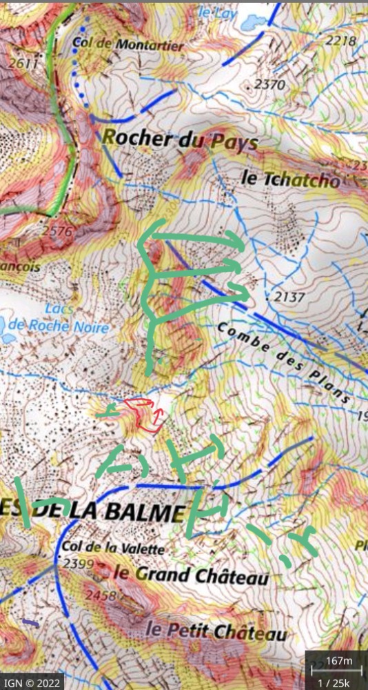
The skiers thought they were taking a safe, low angled passage but got caught by the scale of the slide. Two people caught. One buried under 3 meters of snow, the other partially buried but it appears his airbag kept him on the surface, or he just got lucky.
| Quote: |
Fatal accident occurred on the ascent route towards the Col de la Valette, at the place where to circumvent a steeper relief with bypass to the left which has just been tracked by 3 people. 3 other people engage on this track on the left with distances of about twenty meters while the 3 "tracers" have disappeared from the visual and are on the flatter areas behind. A group of 4 starts a track to the right of the rocky ridge, a bit less steep (On IGN slopes less than 30°, micro passages on the edge of the valley at 30°, steeper rocky ridge).
Our group of 3 begins a drink stop on a flat area next to the rocky outcrop, before taking the right option which seems a little less steep.
As soon as you arrive on this flat area, the slope gives way on the left track, 2 of the skiers are carried away, the 3rd takes a step back and stays outside the slide. The break propagated around the rocky outcrop to the valley on the right, but the flows on the right did not reach the 4 skiers engaged on the right, and our group of 3 moved back a few meters to escape the flow which stops lower on the left, at our level in the middle, a little lower on the right.
The skier taken from the highest triggers his airbag and remains on the surface, buried as far as the hips, unharmed but requiring shoveling assistance to get out.
The 4 +3 + 1 skiers present around search for the buried skier (who was alone, it was necessary to reconstitute how many people were involved), the emergency services are alerted by telephone. The search was not the easiest, and the buried skier was freed 22 minutes after the avalanche, under 3m of snow, a few minutes before the arrival of the first rescue helicopter, with no sign of life.
The resuscitation maneuvers undertaken as soon as the face is accessed and continued with medical treatment will remain a failure.
During the descent, taking a step back, we find that the spread is immense on both sides for almost 1 km, taking all the slopes up to 35° approx. Some flows took on a large volume and reached the bottom of the valley, further upstream.
No rupture was visible before (except one further downstream but therefore covered for more than 24 hours), we deduced that the propagation at a distance, is synchronous with the flow of the accident, including zones which do not were not mobilized due to lack of slope.
Snow condition:
Completely bearing crust under 1 cm of recent snow in the car park, becoming 20cm around 2100. The crust disappeared from around 2150/2200m (stick test)
No visible crack, no woof heard for us (the surviving skier tells us that he heard 2 woofs while passing before.
On IGN (slope overlay), the accident is located in a white zone below 30°, with a yellow passage (30-35°) of a few meters.
The thickness at failure appears to be +/-50cm.
By digging on the descent towards 2200, indeed the first 40 cm of fairly homogeneous aspect rest on a snow without cohesion on at least 10 cm.
BRA risk 2 below 2200, 3 above. |
http://www.data-avalanche.org/avalanche/1671390760445
|
|

|
|
|
|
Obviously A snowHead isn't a real person
Obviously A snowHead isn't a real person
|
The mountain rescue have issued a warning to local skiers to be particuarly careful about risk 3 which they remind people is a "Considerable" risk of skier triggered avalanches.
This is the avalanche bulletin for the sector
Note the Pesistent Weak Layer plus fresh snow windblown by the foehn (so risk of slabs on North sector slopes). It is the kind of conditions that guides call 3+ risk.
| Quote: |
Au-dessus de 2200 m : Risque marqué. En-dessous : Risque limité.
Stabilité du manteau neigeux
Le manteau neigeux conserve quelques instabilités de surface après la neige et le vent (Sud avec foehn) ou de plus
anciennes mais plus enfouies malgré un tassement en cours.
Situation avalanche typique : neige fraîche, sous-couche fragile persistante.
Départs spontanés : on ne peut exclure une ou deux avalanches, petites à moyennes, avec le bon ensoleillement, en
pentes suffisamment raides.
Avalanches accidentelles : des plaques sont encore présentes au-dessus de 2200/2400 m. Des sous-couches
anguleuses, pas encore suffisamment enfouies, rendent leur rupture possible avec une surcharge apportée par le
passage d'un ou plusieurs skieurs, tout particulièrement en expositions Ouest à Est en passant par le Nord (cassure de
30 à 40 cm). Cette probabilité est moindre sous 2200 m où la pluie du mercredi a transformé et commencer à stabiliser
ces couches fragiles.
|
Some feedback from skiers in the sector:
i. They focussed on the risk 2 < 2200 (they were only touring to 2400 meters so didn't significantly take into account the abrupt change in conditions over a very short change in altitude
ii. They were on a low angled route - most of the terrain is 25 degrees and didn't take into account the small passages of steeper terrain or the threat of remote triggering of slopes above.
I hope this is useful information. With the thaw / rain / snow / wind the situation will evolve over the next days but keep an eye on that PWL.
|
|
|
|
|
|
Well, the person's real but it's just a made up name, see?
Well, the person's real but it's just a made up name, see?
|
Sheesh- scary. Sounds like they were playing it quite safe by most standards 
Thanks for posting- a good reminder for those of us who venture off piste
|
|
|
|
|
|
You need to Login to know who's really who.
You need to Login to know who's really who.
|
| Arno wrote: |
Sheesh- scary. Sounds like they were playing it quite safe by most standards
|
Yes that seems to be the case and feedback from people on the scene was they'd chosen the route after looking at the avalanche risk. It was just the group that went through the pinch point with the rock outcrop that were caught. Certainly they were very unlucky but also it shows that minor details can make a big difference. There were already tracks on this route apparently. Otherwise the Col de la Valette should be reachable without serious exposure.
|
|
|
|
|
|
|
|
|
|
|
|


