Poster: A snowHead
|
|
ECMWF&GEM also starting to shift?
|
|

|
|
|
|
Obviously A snowHead isn't a real person
Obviously A snowHead isn't a real person
|
|
|
|
Well, the person's real but it's just a made up name, see?
Well, the person's real but it's just a made up name, see?
|
| Quote: |
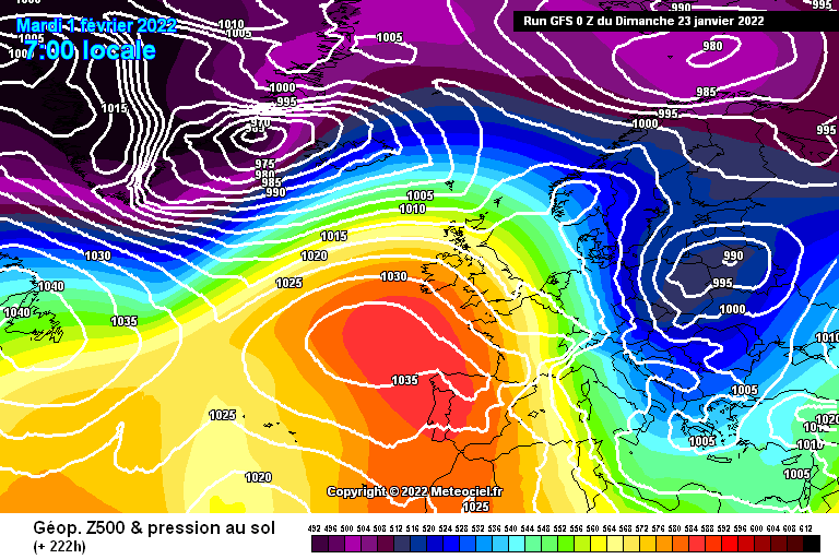
Here is the anticyclone that is giving settled weather over the western Alps and most of the UK.
|
Can we start naming anticyclones? Not traditional to start with S but I would name this one Stubborn.
|
|
|
|
|
|
You need to Login to know who's really who.
You need to Login to know who's really who.
|
| Quote: |
Can we start naming anticyclones?
|
Great idea 
P for persistent.
|
|
|
|
|
|
Anyway, snowHeads is much more fun if you do.
Anyway, snowHeads is much more fun if you do.
|
| Quote: |
Can we start naming anticyclones?
|
Great idea
P for persistent.
|
|
|
|
|
|
You'll need to Register first of course.
You'll need to Register first of course.
|
I've got an A - Ad Infinitum 
|
|
|
|
|
|
|
|
Like the look of that end of the month from YR…

|
|
|
|
|
|
|
|
|
|
|
You'll get to see more forums and be part of the best ski club on the net.
You'll get to see more forums and be part of the best ski club on the net.
|
|
Heading to Tignes on Saturday. It’s not looking good for snow but can anyone provide some optimism that there could be some fresh stuff?
|
|
|
|
|
|
|
|
|
|
|
snowHeads are a friendly bunch.
snowHeads are a friendly bunch.
|
@blacksheep scroll up 
|
|
|
|
|
|
And love to help out and answer questions and of course, read each other's snow reports.
And love to help out and answer questions and of course, read each other's snow reports.
|
| hd wrote: |
| @blacksheep scroll up |
I guess the chart just above my post are the ones I should be looking at? Sorry I'm not adept are interpreting them. Suggests there may be a chance of some change moving in next week but France is on the fringes of it?
|
|
|
|
|
|
|
|
| blacksheep wrote: |
| I guess the chart just above my post are the ones I should be looking at? Sorry I'm not adept are interpreting them. Suggests there may be a chance of some change moving in next week but France is on the fringes of it? |
| nozawaonsen wrote: |
Period round 31 Jan/01 Feb looking interesting on GFS op.
And things brewing on ECM too.
Too far out at this stage, but worth watching!  |
You won't get any better overview of the situation this far out from anywhere else than Noza saying "interesting".
|
|
|
|
|
|
You know it makes sense.
|
|
Just booked St Anton for the 5th Feb, looks like it's brewing something for the week before (as above) and there are bumps in the ensembles out to the end............ hopefully one or two of them consolidate.
|
|
|
|
|
|
Otherwise you'll just go on seeing the one name:
Otherwise you'll just go on seeing the one name:
|
Turn of the month still showing promise on both ECM and GFS for an incursion of snowy weather. Obviously details and confidence still unclear.
Meantime further light snow heading for Austria at end of week.
|
|
|
|
|
|
Poster: A snowHead
|
|
|
|
Obviously A snowHead isn't a real person
Obviously A snowHead isn't a real person
|
|
|
|
Well, the person's real but it's just a made up name, see?
Well, the person's real but it's just a made up name, see?
|
|
Now that everything appears to opening up and travel is as we speak getting simpler my attention now turns to this thread for Haute-Savoie
|
|
|
|
|
|
You need to Login to know who's really who.
You need to Login to know who's really who.
|
| Quote: |
Turn of the month still showing promise on both ECM and GFS for an incursion of snowy weather. Obviously details and confidence still unclear.
|
Many SnowHeads headed for the Birthday Bash in the Dolomites will be offering up prayers for fresh snow around the turn of the month - ie next week!
Keep up the good work @nozawaonsen, your posts make sense of the complexity while still allowing scope for wild optimism!
|
|
|
|
|
|
Anyway, snowHeads is much more fun if you do.
Anyway, snowHeads is much more fun if you do.
|
|
@tomj, Dolomites may be on the wrong side to get the snow. Right side to get outrageous food and wine mind you…
|
|
|
|
|
|
You'll need to Register first of course.
You'll need to Register first of course.
|
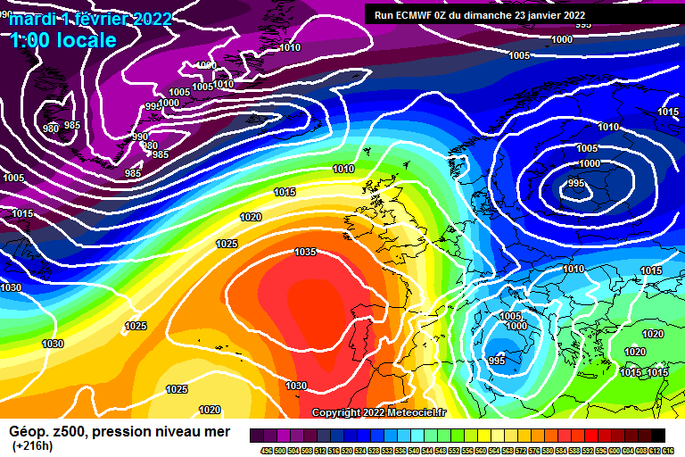
How it looks this evening to +180h on GFS.
|
|
|
|
|
|
|
|
anyone know how many letters of no confidence we need to send on @admin, to the 1080 back country committee to get this thread made sticky ? 
|
|
|
|
|
|
|
|
cannot believe I gave up my Austrian accommodation in Warth and switched to Val D'isere, when you look at the snow potential  never thought they'd change their rules for 16 year olds and they did ! Come on Western Europe... never thought they'd change their rules for 16 year olds and they did ! Come on Western Europe...
|
|
|
|
|
|
You'll get to see more forums and be part of the best ski club on the net.
You'll get to see more forums and be part of the best ski club on the net.
|
| Little Martin wrote: |
| anyone know how many letters of no confidence we need to send on @admin, to the 1080 back country committee to get this thread made sticky ? |
+1
And unstick the Dolomites thread whilst they're at it.
|
|
|
|
|
|
|
|
|
@Little Martin, @hd, +2. I did ask in October. A straight sticky swap with 20/21
|
|
|
|
|
|
snowHeads are a friendly bunch.
snowHeads are a friendly bunch.
|
@hd, thanks for the cue
A quick look back at some earlier observations....on Jan 11th it looked like the rest of Jan would be largely dry in the west, based on the NOAA 6-10 day and 8-14 day mean charts, found here
https://www.cpc.ncep.noaa.gov/products/predictions/610day/500mb.php
For me, this is the single most important chart and the first one I look at every morning. Being US centric it's at an awkward angle for the alps and is complex to read, I might do a post on it someday but essentially just look for the areas of high pressure (red dashed lines). Still showing high anomalies into western europe for the foreseeable, but because it's a 6 day average it can easily include a quick one or two day incursion of low pressure.
EC46 last night still showing high pressure way into Feb, again weekly charts, but the pattern looks more like a typical +NAO pattern than Jan. With the strat still raging above it's looks set to finally connect with the trop patterns and override any atlantic ridge default. But there is a dip in strat winds and AO into early Feb first....and anything beyond 2 weeks is totally unreliable.
The other essential charts imv are the GEFS and GEM mean anomaly charts for days 10-14. These also gave a glimmer of hope for the high to briefly regress west and open the door to some NW action, the pattern favoured the east in general, and is quickly followed by more dry sunny conditions. Charts are on the usual meteociel site, click 'moyenne' and Z500 anomaly. Even at 12-13 days out they were showing the early Feb potential....same data as the precip spikes on the Wetterzentral charts.
Note ECM only goes to day 10, and UKMO / ICON day 7.
Which brings us to the more reliable time frame, 6-7 days away. Here is ECM and GEM showing the high west of Ire and NW flow into alps....ECM slightly further west than the others, I'd expect a meeting in the middle, ie ECM might slide east too.


Finally a new addition to the array of charts is the UKMO day 8 chart....used to only go to t+144, but now you get the extra day by clicking on the "HD 0.1 Europe link". @hd is this your handy work?
https://www.meteociel.fr/modeles/ukmoeu.php

Don't like the way high pressure is nudging into Switzerland and deflecting the flow, but we'll take what we can here in the beautiful west.....despite some moaning, the pistes are in excellent condition down to 1200 where I am. Will be happy with 10-15cms if that's all the snowgods deliver.....then back to sunny and dry, and hopefully not too warm....GFS Op seems hell bent on rising temps 3-7th, but the mean is still ok.
|
|
|
|
|
|
And love to help out and answer questions and of course, read each other's snow reports.
And love to help out and answer questions and of course, read each other's snow reports.
|
|
|
|
|
|
@BobinCH, yep ECM (YR.NO) is the single most reliable model, but it's out on it's own with recent runs so far west.....GFS 06z just out now slides even further east. I'd bank 10cm right now, but obviously hoping for a correction the other way....the ECM mean is still solid as per above chart, but not supported....next few runs will settle it
GFS 06z for comparison to above....too far east

But 2 models now showing a reload around the 4-5th.....so it's becoming more mobile and unpredictable as the atlantic finally springs back to life
|
|
|
|
|
|
You know it makes sense.
|
|
Looking like quite a bit of snow for Austria early next week
|
|
|
|
|
|
Otherwise you'll just go on seeing the one name:
Otherwise you'll just go on seeing the one name:
|
For those in the East all is well but in the west once these anti cyclones get established they’re as Stubborn as Boris J , might be mid Feb or further till we enjoy some real snow .
Contrary to another thread on this site , it’s not unusual , it’s why snow machines were invented . Longtime since a bad snow year in France and this isn’t one of them .
|
|
|
|
|
|
Poster: A snowHead
|
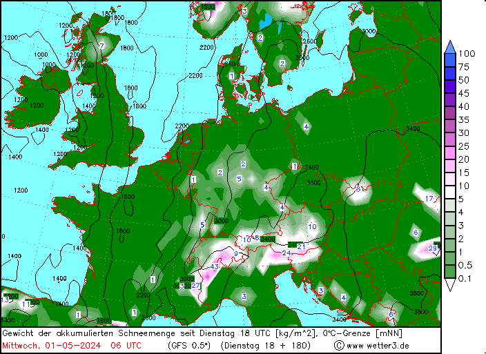
How it’s looking on GFS this morning.
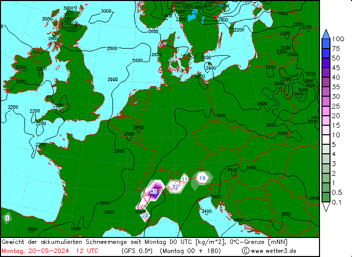
Austria looking to be the main beneficiary with Salzburgerland in particular looking to be the focus.
|
|
|
|
|
|
Obviously A snowHead isn't a real person
Obviously A snowHead isn't a real person
|
|
@nozawaonsen, no pic showing
|
|
|
|
|
|
Well, the person's real but it's just a made up name, see?
Well, the person's real but it's just a made up name, see?
|
|
|
|
You need to Login to know who's really who.
You need to Login to know who's really who.
|
@nozawaonsen, @Alpinebear, +1
Link bookmarked 
|
|
|
|
|
|
Anyway, snowHeads is much more fun if you do.
Anyway, snowHeads is much more fun if you do.
|
|
@nozawaonsen, strange that yours is the only pic that doesn't show for me
|
|
|
|
|
|
You'll need to Register first of course.
You'll need to Register first of course.
|
Agree with @polo, EC is the best model, but has been way too agressive in the latest runs. Heading towards the GFS-solutions lately (especially EC00 this morning). I found it hard to believe that we were in for a large scale change with the ever-persisting strong polar vortex, the very cold weather over Eastern Cananda meeting warm water (creating these intense low pressure system in the Northern Atlantic) and solid high pressure in the Eastern Athlentc / UK / Western Europe.
I believe that this will not change in the first half of Februray. Thus, more of the same with intense low pressure hitting Scandinavia and High pressure influence over the Continent. But you might have some episodes of Northstau like at the end of this month. In the beginning of February, the High might go move to become a more classical Azore high. Again, lot of activity for the Northern Athlentic, but might move more episodes to the Alps. Classic NAO +. North of the Alpine rigde is the place to be for the snow that is coming. Not much optimism for Italy apart from maybe some very light dust..
|
|
|
|
|
|
|
|
@Woosh, I think there is a large scale change coming with the atlantic soon unblocking. Looking at the Nov-Dec chart can see that most of the alps had a great early start (been so many in the last 6-7 years), with the jet stream bending around UK back towards alps / med. Eastern end was driest with above avg temps. High pressure centered in the north atlantic.

Looking at January to date, we can see how the same pattern has just shifted E/SE....atlantic high now closer to UK, jet running into Slovakia / Hungary.....Eastern Austria doing well

The models are picking up on a flatter atlantic profile into Feb and there is a lot of cold air bottled up to the north, so any low's dipping SE across europe will initially bring colder than expected temps (pattern wise). Definitely looking more stormy for northern europe....but with these more mobile westerly patterns there is always the risk of warm air mixing in so snow might not be as good as before at low altitude. If it happens at all.
Re. next week am still not writing off the west completely, ICON, UKMO, ECM showing a little hope, while GFS remains fairly hope-less. The key short wave area of low pressure is currently developing over North America and is 6 days away from potentially reaching the alps on a difficult trajectory over UK and dropping sharply south to alps. Definitely a low confidence route for the west.
Of the 7 models on this link, 2 are showing zero precip for northern french alps, 2 are showing 10-20, and 3 are suggesting 30cm ish.....averaging about 10-15cm
https://meteologix.com/fr/model-charts/swiss-mrf/france/accumulated-precipitation/20220202-1800z.html
|
|
|
|
|
|
|
|
|
Much further south and along way into the Atlantic compared to the Alps, it is snowing in Sierra Nevada today with it forecast to continue lightly into tomorrow
|
|
|
|
|
|
You'll get to see more forums and be part of the best ski club on the net.
You'll get to see more forums and be part of the best ski club on the net.
|
|
February shaping up nicely for a return to pow
|
|
|
|
|
|
|
|
https://wepowder.com/en/forum/topic/283626
| Quote: |
Lots of snow next week
Early next week it looks like there is going to be a lot of snow for the Northern Alps when a new low pressure area from over the North Sea deflects to the southeast and creates a strong northerly flow. Friday will probably bring PA#5 for snowfall after the weekend in Austria.
The southern Alps will still have to be patient and not expect any snow with the increasing Nordföhn, but the new depression will take a slightly more direct course from the North Sea towards the Alps, increasing snow chances for Switzerland on Monday. Again, for this situation, the high pressure area west of the Alps is very close and could throw a spanner in the works in the coming days. I think most of the French areas will be out of the question again. The GFS is already a lot less positive than the European weather model. The rest of the Northern Alps might get more than half a meter of snow up to Wednesday, but where the snowfall will be concentrated will become clear in the coming days. At the moment is looks like Austria has the highest chance for a lot of snow next week. |
|
|
|
|
|
|
|
|