 Poster: A snowHead
|
| BobinCH wrote: |
If it’s an image file - .png/.jpg etc just use the [img][/img] tags around it to embed the image |
Thanks. Turns out that although it was an image, it wasn't an image file, so probably would have needed to use my Snowmediazone account.
|
|

|
|
|
|
Obviously A snowHead isn't a real person
Obviously A snowHead isn't a real person
|
|
|
|
Well, the person's real but it's just a made up name, see?
Well, the person's real but it's just a made up name, see?
|
| BobinCH wrote: |
Any ideas why my link isn’t updating any more since last week?
 |
This is still not working? Anyone got another Chamonix wiggles link?
|
|
|
|
|
|
You need to Login to know who's really who.
You need to Login to know who's really who.
|
|
|
|
Anyway, snowHeads is much more fun if you do.
Anyway, snowHeads is much more fun if you do.
|
Chamonix - this any good?
|
|
|
|
|
|
You'll need to Register first of course.
You'll need to Register first of course.
|
|
|
|
|
|
Armageddon in Andermatt!!!

|
|
|
|
|
|
|
|
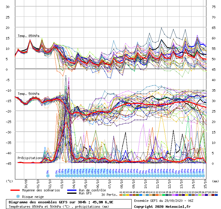
This is a very local example of a wider model issue. GFS has been consistently predicting a FL of about 1500m tomorrow morning in the Haute Savoie, but it is way out on it's own vs all the others. WRF has a low of 2100m, Arome has 1900m, and 9 other models have an average low of 1900m on the link below.
https://meteologix.com/fr/model-charts/standard/haute-savoie/0-isotherm-height/20201003-0600z.html
I really like these meteologix links as once you set the area and date (eg end of a storm), the link will automatically update with the latest runs, and add in more models as they come into date range. So handy to compare predicted FL and precipitation / snow depth across many sources.
GFS 06z out just now sticks to it's guns with 22mm at a FL of 1490m at 8am....so you'd expect about 20cm of snow below 1400m. We've seen examples where the snowline can be different by 200-300m either way (mostly higher), but I can't recall such a big FL divergence by one model with only 20 hours to go. But then again I can't remember where I parked the car either, so it could be just me.
One other general problem with interpreting these precip windows is that GFS etc will show 20cm from 5am to 8am. But if the FL is falling rapidly during those 3 hours, I don't know if they show the average FL for that window, or the FL at the end. Some models such at WRF have hourly breakdowns, and they clearly use the FL at the end of a 3hr window.....so that's a bit misleading too, ie in this case there might only be a few cm at the lowest point.
Way too much detail, as it's all fairly accademic when predicting these things, more a look at how summarised model output (snow-forecast 8hr buckets) can be misleading in it's own right, and vastly different to other models too.
Update....I've just checked Chamonix meteo (quoted below) and they are in line with the model average (excluding GFS) of 1900m FL at it's lowest point, with maybe some snow down to 1600m and a lot of rain below. If you only looked at GFS output in this case (and free apps) you might be disappointed at low altitude..... or alternatively GFS will put all the other models to shame and we'll see 20-30cm down to 1300m.
"OVERNIGHT
Bad weather ‑ foehn ending ‑ heavy precipitation ‑ snow toward 1600 m
SKY CONDITION : mostly cloudy on the whole, yet fleeting sunny spells ‑ iso 0°C dropping occasionally towards 1800‑2000 m.
PRECIPITATION : heavy shower running from south, then abundant continuous rain spreading towards the middle of the night ‑ rain‑snow limit dropping towards 1600 m at times ‑ possible water amount in the valley, since precipitation beginning : 30‑40 mm ‑ probably ending by dawn."
06z view to monday

|
|
|
|
|
|
You'll get to see more forums and be part of the best ski club on the net.
You'll get to see more forums and be part of the best ski club on the net.
|
|
Looks like a great call by GFS with the snow line down to 1200m here, albeit a dusting. From the cams there’s 10cm settled at 1600m, so almost as good as last weekend. On the other hand GFS 0z had 40cm in the morning forecast at 1400m, so it only got cold at the very end of the storm.
|
|
|
|
|
|
|
|
Does anyone know if the Dolomites have been hit by this latest storm? The area was hit by bad storms two years ago; which did no end of damage. 
|
|
|
|
|
|
snowHeads are a friendly bunch.
snowHeads are a friendly bunch.
|
|
|
|
And love to help out and answer questions and of course, read each other's snow reports.
And love to help out and answer questions and of course, read each other's snow reports.
|
|
@Scarlet, thanks. Looks pretty bad. I hope the little gorge that Alistair Pink takes trips out to is not hit again. Fingers crossed the local businesses and residents are not too badly affected.
|
|
|
|
|
|
|
|
|
|
|
You know it makes sense.
|
Thanks. Perfect
|
|
|
|
|
|
Otherwise you'll just go on seeing the one name:
Otherwise you'll just go on seeing the one name:
|
Winter is most definitely coming. Another dump to low levels on the way

|
|
|
|
|
|
Poster: A snowHead
|
@BobinCH, yep this was GFS00z.
Obviously those numbers will shift back and forth a bit more still.
|
|
|
|
|
|
Obviously A snowHead isn't a real person
Obviously A snowHead isn't a real person
|
|
I am quite amazed that the main piste down to Tuxer Fernerhaus at Hintertux is open. Web cam in operation at least three weeks earlier than last season. Currently set with race gates. I hear Norwegian team had been training there. Shows how much early snow they received over last two weeks. More showing on the forecast (?)
|
|
|
|
|
|
Well, the person's real but it's just a made up name, see?
Well, the person's real but it's just a made up name, see?
|
|
This might be of interest to a few https://www.severe-weather.eu/global-weather/ecmwf-model-winter-forecast-free-public-access-mk/ . Some of the charts are a bit beyond my grasp of atmospheric physics but many are interesting. There is a fair amount about medium to long term forecasts. I know these are not always viewed positively here but the suggestion so far is that Europe is likely to see a fairly mild winter although there the arctic circulation pattern might be conducive to short cold snaps (unlike last season).
|
|
|
|
|
|
You need to Login to know who's really who.
You need to Login to know who's really who.
|
@Bennyboy1, yep that chart just above refreshes every day for 00z run, rolling for the next 8 days. Eastern and central parts favoured for the weekend, while the west and south could do well into mid week.
@munich_irish, been a lot of excitement about the ECM releases, especially longer term charts. Most of the short term data I use is already out there if you know where to look, ie ensembles, mean anomalies and precip/FL data. But this change will open up a lot of the more technical indicators too and access to historical data.
That ECM winter anomaly chart in the link isn't that bad, especially for northern alps. Can see the jet stream would be mostly from the NW thanks to the atlantic ridge, which is much better than SW flow if western europe was under a large block of high pressure. So there are many different shades to a +NAO signal, even if that happens, and being a 3 month average might not show epic short term negative periods like the one coming up.
GFS has one or two ensembles dropping to -5 or -6 mid month, which is extreme. An index of -2 to -3 would be considered very strong too.

ECM on the left has an even stronger -AO anomaly in the 8-10day range. Both models showing 4 areas of low pressure being pushed out to the mid latitudes around the northern hemisphere. Quite a southerly looking jet for europe with that cut off low stuck under the northern blocking. So the below average temps will conitnue well into mid Oct with some useful snowfalls.

Here's the link to new ECM hub
https://apps.ecmwf.int/webapps/opencharts/
And the current 10-15 day temp probabilities

|
|
|
|
|
|
Anyway, snowHeads is much more fun if you do.
Anyway, snowHeads is much more fun if you do.
|
Matterhorn morning.
|
|
|
|
|
|
You'll need to Register first of course.
You'll need to Register first of course.
|
| nozawaonsen wrote: |
Matterhorn morning. |
Lovely photo!! Still snowing in the Dolomites this morning down to village level.
|
|
|
|
|
|
|
|
|
|
|
|
|
|
|
|
You'll get to see more forums and be part of the best ski club on the net.
You'll get to see more forums and be part of the best ski club on the net.
|
|
First dusting of snow in the Cascades. Down to about 1,300 meters. Will all melts except maybe at the very highest elevations. But nice to see a bit of white. Sure to be a welcome sight for the fire fighters battling the forest fires here in Oregon too.
|
|
|
|
|
|
|
|
|
Webcams in Mayrhofen showing the snowline to about 750-800 metres this morning. I'm sure it won't last, but pretty impressive for this early in the Autumn. Freezing levels look to stay low (although not quite that low) for the foreseeable
|
|
|
|
|
|
snowHeads are a friendly bunch.
snowHeads are a friendly bunch.
|
Alta Badia looking pretty in the sun.
|
|
|
|
|
|
And love to help out and answer questions and of course, read each other's snow reports.
And love to help out and answer questions and of course, read each other's snow reports.
|
|
|
|
|
|
The bestest, wasted snow this winter................ 
|
|
|
|
|
|
You know it makes sense.
|
Looks like the cold spell is coming to an end heading into the last third of October. Despite the AO dropping to -3 and NAO -1.5, it goes to show how neither of these states guarantees any particular outcome for a small area such as the alps.
A deep area of low pressure around the azores / east atlantic is one of the worst positions for the alps as it drives up warm air from north africa.
The AAM index has started it's long awaited rise over the next week or two, so maybe that's helping to raise the pressure over western europe.
The other notable feature is how once again the models have struggled to forecast any high pressure taking hold over scandi....I would say 19 times out of 20 (undercut scenarios) they underestimate the sinking of high pressure back down into central europe.
ECM00z shows the high over france, troublesome looking low out to the west, and likely +8c temp anomalies (currently -8c).

|
|
|
|
|
|
Otherwise you'll just go on seeing the one name:
Otherwise you'll just go on seeing the one name:
|
|
|
|
Poster: A snowHead
|
Snowfall out east over next three days. Heaviest around Salzburgerland land 30cm+. 10-20cms for rest of Austrian Alps. Starting around 800m then rising to 1400m by Saturday.
Europe quite chilly at present.

|
|
|
|
|
|
Obviously A snowHead isn't a real person
Obviously A snowHead isn't a real person
|
ENSO forecasts suggesting a pretty intense La Niña.

This would be the strongest since 2010/2011 (which had an exceptionally cold start to winter and if I remember a better season overall in Italy, but that’s a bit impressionistic and of course hardly a guarantee that we’ll see a repeat).
|
|
|
|
|
|
Well, the person's real but it's just a made up name, see?
Well, the person's real but it's just a made up name, see?
|
How about a sunday afternoon chart splurge.....
First there's the underwhelming model output this morning regarding the rest of October....the warm up next week getting temps to +8 to +12 at the maximum

The uncertainty has all been about what happens next....
ECM has backed off from the idea of atlantic lows digging SE into central europe, instead building high pressure over northern europe and eventually up into scandinavia.

GFS hanging on to the idea of a brief NW-SE flow (good for snow)

While GEM is somwhere in the middle, with a cut off low over southern europe

So no sign of a sustained rise temps in at least, but it's also looking more blocked than recently in terms of atlantic low's reaching the alps.
Now for La Nina...the more I read about it the less clear I am on what it means for europe. What we do know is that the impact is much more direct in North America....with high pressure in the north pacific and low pressure down across Canada.
Most analysis will also show an atlantic ridge, which is normally useful for NW europe snow. But the caveats here are that russia / eastern europe can also see a high pressure ridge, or that the atlantic /azores high extends into western europe.
So many commentators state that La Nina leads to milder than average winters for europe. But for the alps it all depends on where the high pressure sets up....relatively small shifts in just the atlantic ridge positioning can literally make a 20-degree temp difference. If we get a west based -NAO (like right now, see below), low pressure near the azores drives the warm air up into europe.

Whereas if the atlantic ridge sets up more towards the east Atlantic.....we'd get snow from the NW-SE jet heading to the alps, like the GFS one I posted a few days ago in FI for end of Oct (now even less likely)

For the purists out there, the above chart isn't stricty -NAO.....you'd need to see the high pushing a bit further north and turning the wind flow more northerly.
So, La Nina as a stand alone factor is at best ambiguous, and at worst, relatively mild and dry (blocked?) in terms of impact on the alps. The two other qualifying factors are whether it's a central (modoki) La Nina or an east pacific La Nina. From what I have read east based La Nina's have a better track record for a colder europe.....which makes sense when you envisage the global ridge / trough long wave pattern moving east. The other factor is the strength of La Nina, and everything I've read suggests a weak to moderate La Nina (-0.5 to -1.5c below average) is preferable to a strong La Nina if you want troughing into europe. I'll try to find the research on this.
At the moment we have an east based cold anomaly in the pacific, but as pointed out above, CFS at least is forecasting a very strong La Nina.
Here's a handy link to view previous ENSO events.....eg 16/17 and 17/18 were weak La Nina, and led to good early season snowfall. 2010/11 was the last strong event, and led to the most UK december snow in a hundred years.
Maybe others will remember more about good / bad La Nina years from the late 90's?
https://ggweather.com/enso/oni.htm
Conclusion: snow to continue on and off through the coming winter.
|
|
|
|
|
|
You need to Login to know who's really who.
You need to Login to know who's really who.
|
| Quote: |
So, La Nina as a stand alone factor is at best ambiguous, and at worst, relatively mild and dry (blocked?) in terms of impact on the alps. The two other qualifying factors are whether it's a central (modoki) La Nina or an east pacific La Nina. From what I have read east based La Nina's have a better track record for a colder europe.....which makes sense when you envisage the global ridge / trough long wave pattern moving east. The other factor is the strength of La Nina, and everything I've read suggests a weak to moderate La Nina (-0.5 to -1.5c below average) is preferable to a strong La Nina if you want troughing into europe. I'll try to find the research on this.
|
All of this is right, the idea goes that you often see a -NAO more fluid jet stream setup in early winter. And then a more +NAO like setup later on.
I can certainly see a moderate basin wide Nina, the specifics will be interesting, but as you say their impact on weather patterns can be somewhat ambiguous so far away.
|
|
|
|
|
|
Anyway, snowHeads is much more fun if you do.
Anyway, snowHeads is much more fun if you do.
|
|
|
|
You'll need to Register first of course.
You'll need to Register first of course.
|
@Jellybeans1000, thanks, good to have some feedback.
I've had time to run thru some of the analogs....and just focused on the NW alps as that is all I have snow data for (at 1300m). No doubt the southern alps would be a different story.
Weak La Nina years
05/06 Above average snow fall (-AO, euro trough)
08/09 Above (-AO, euro trough)
16/17 Above (Scandi block)
17/18 Average (-AO, euro trough)
Moderate La Nina
55/56 Above (-AO, euro trough)
70/71 Average (-AO, euro trough)
95/96 Average (-AO, euro trough)
11/12 Average (+NAO, azores block western europe)
Strong La Nina
88/89 Below avg (+NAO, azores block western europe)
98/99 Record snow (-AO, euro trough, strong east atlantic ridge)
99/00 Average (+NAO, azores block western europe)
07/08 Average (+NAO, azores block western europe)
10/11 Below avg (-AO, southerly jet)
It's a small sample size and I've haven't looked at other drivers such as solar max/min, QBO, SSW's etc which all play a big part.
Other factors might be whether it's an emerging ENSO state or a mature one, and whether to look at early season vs mid season differences.....but here I've just done Dec-Mar
Overall they show consistent high pressure over the pacific (mostly north), low pressure thru Canada / North America, and a fairly mixed picture over europe. The most consistent euro feature is -AO (9 out of 13), and as a consequence the jet stream often digging south into europe.
The weak and moderate La Nina's all produced decent snowfalls for NW europe, while the 5 strong years were more volatile, with 4 relatively poor years and one with record snowfall (over the last 30 years).
            
Re. next week, GFS is still hinting at a weak trough dropping in Mon/Tues, but ECM not so interested. Big differences in how they model the ex-tropical storm in the atlantic as it curves back NE and joins the jet stream.
Even the ensemble means are quite different for the last week of Oct. The AAM is showing a slight downtrend from Oct 24th into November, while NAO and AO are currently heading moderately positive into month end, so not much clarity.

|
|
|
|
|
|
|
|
Just swinging back to 2010/11 (most recent very strong La Niña conditions) November and December had some very cold weather and excellent snow in northern Alps till a warm spell at Christmas before recovering briefly. This was accompanied by very -NAO at the start of winter before it switched:
Nov -1.62
Dec -1.85
Jan -0.88
Feb +0.70
Mar +0.61
Much of the post Christmas winter period saw mild and dry conditions in the northern Alps. As ever there was good skiing to be had, but you had to have a poachers eye and be ready to move fast. Consistent with a more southern jet Italy however had a pretty good season with some great snowfall.
That said analogoue, schmanalogue of course...
|
|
|
|
|
|
|
|
@nozawaonsen, yep that matches the last anomaly thumbnail above for 10/11, very southerly jet, with no atlantic ridge at all, but northern blocking in Greenland / Iceland.
Average Dec-Mar NAO still -1.43 which is visible on the 4 month chart.
Just found this other interesting breakdown of modoki vs east based....seems all 5 of the strong La Ninas have been modoki (central)

|
|
|
|
|
|
You'll get to see more forums and be part of the best ski club on the net.
You'll get to see more forums and be part of the best ski club on the net.
|
|
|
|
|
|
|
|
|
|
|


