Poster: A snowHead
|
| polo wrote: |
Despite the UKMO dragging it's heels at 120-144, it's only a matter of time according to ECM and GFS mean 8-10 day charts.
Incoming vortex.
 |
Can you elaborate on the ‘incoming vortex’ and what it’s impact will be to alps.....+ive or -ive for the alps etc
|
|

|
|
|
|
Obviously A snowHead isn't a real person
Obviously A snowHead isn't a real person
|
|
That just looked fabulous
|
|
|
|
|
|
Well, the person's real but it's just a made up name, see?
Well, the person's real but it's just a made up name, see?
|
@Sneachta2013, stormy, lots of rain/snow coming from W/NW. As mentioned think the east does best initially, but too far for detail.
It's unusual to see such a large deep area of low pressure over northern europe, but ideally we need more amplification / ridging of high pressure in the Atlantic to turn the winds more northerly over alps.
As it stands low pressure systems are either too flat (westerly), or prone to sinking towards iberia.
So I imagine we're going to get plenty of wild weather, rain, then snow at low altitutde, chaos higher up.
Followed by an outbreak of scattered GoPro use and occasional drone footage.
|
|
|
|
|
|
You need to Login to know who's really who.
You need to Login to know who's really who.
|
|
|
|
Anyway, snowHeads is much more fun if you do.
Anyway, snowHeads is much more fun if you do.
|
|
|
|
You'll need to Register first of course.
You'll need to Register first of course.
|
> Nombre d'accidents mortels and Nombre de décédés
to make year to year comparisons the number of incidents involving at least one fatality (Nombre d'accidents mortels) is used rather than the total number of dead (Nombre de décédés) as it removes a very large variable.
The number of fatalities divided by the number of avalanches involving fatalities gives you an idea of the severity of avalanches in a single year wrt to other years.
Journalists like whichever figure is more dramatic as they don't understand statistics, but understand journalism.
|
|
|
|
|
|
|
|
|
|
|
|
|
There were 12 incidents where people died and 13 deaths. The 60 figure is the number of incidents reported, generally only incidents involving the rescue services get reported (and then sometimes not).
There were not many fatal avalanches incidents in 2018/19 and they were not very serious. The good figures compared to the long term average reflect generally stable snow conditions last season.
|
|
|
|
|
|
You'll get to see more forums and be part of the best ski club on the net.
You'll get to see more forums and be part of the best ski club on the net.
|
| davidof wrote: |
| ......There were not many fatal avalanches incidents in 2018/19 and they were not very serious. The good figures compared to the long term average reflect generally stable snow conditions last season. |
Yes previous season !!!!
Bilan des accidents d'avalanche 2017 - 2018
79 accidents d'avalanche recensés
139 emportés
49 ensevelis (tête sous la neige)
37 décédés
54 blessés
48 indemnes
and this was the season when there were those horrendous CAF related avalanches when six were killed in the Queyras
Bilan des accidents d'avalanche 2015 - 2016
46 accidents d'avalanche recensés
116 emportés
36 ensevelis (tête sous la neige)
21 décédés
44 blessés
51 indemnes
|
|
|
|
|
|
|
|
|
|
|
snowHeads are a friendly bunch.
snowHeads are a friendly bunch.
|
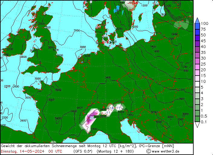
All sorts of options getting thrown out by the models into mid Dec.....
Monday 9th looks good for snow across the northern ridge, pretty evenly distributed, might get 20-30cm locally.
High pressure rolls in quickly before the next low on Wednesday / Thursday. These fast moving westerly systems start with a high snowline in the NW alps (>2000) but quickly drop to low levels (<1000).
Quite a difference in models at +144, so not a certainty yet that the mid week low will dig far enough SE towards the alps.
Chart shows the wildest of the bunch, ICON with a 950mb centre low west of Ireland.

Not much point speculating beyond that, due to near term differences etc, many possibilities showing up, from continued stormy low pressure, to mild SW flow and high pressure.
Ensemble mean temp fluctuating around 0c at 1500m for forseeable, so close to average.
|
|
|
|
|
|
And love to help out and answer questions and of course, read each other's snow reports.
And love to help out and answer questions and of course, read each other's snow reports.
|
For those that want to get some beach time with their skiing, you can always hit up Hawaii.
https://www.yahoo.com/news/winter-storm-could-dump-6-134940989.html
A winter storm could dump more than six inches of snow in Hawaii at higher elevations on Thursday and Friday.
The National Weather Service has issued a winter storm watch for summits above 12,000 feet on Hawaii’s Big Island, warning of “significant snow, sleet or ice accumulations.”
Hawaii has several high mountain peaks. Mauna Kea, the highest point in the state, towers at close to 13,800 feet.
|
|
|
|
|
|
|
|
|
|
|
You know it makes sense.
|
| Toadman wrote: |
For those that want to get some beach time with their skiing, you can always hit up Hawaii.
https://www.yahoo.com/news/winter-storm-could-dump-6-134940989.html
A winter storm could dump more than six inches of snow in Hawaii at higher elevations on Thursday and Friday.
The National Weather Service has issued a winter storm watch for summits above 12,000 feet on Hawaii’s Big Island, warning of “significant snow, sleet or ice accumulations.”
Hawaii has several high mountain peaks. Mauna Kea, the highest point in the state, towers at close to 13,800 feet. |
Mount Kea had a couple snow-pukes in Nov. Been chilly down-south.
Buddy is nextdoor in Maui and watched a tiger shark chomp on a paddleboard, a few days ago.
.jpeg)
|
|
|
|
|
|
Otherwise you'll just go on seeing the one name:
Otherwise you'll just go on seeing the one name:
|
Looking at the forecasts, just now, France will do well this weekend and into early next week.
3Vs and Val-Tignes will be good.
|
|
|
|
|
|
Poster: A snowHead
|
|
|
|
Obviously A snowHead isn't a real person
Obviously A snowHead isn't a real person
|
|
@Whitegold, Good for snow but possibly not for skiing ?
|
|
|
|
|
|
Well, the person's real but it's just a made up name, see?
Well, the person's real but it's just a made up name, see?
|
|
Gfs has gone bezerk for 12/13th next week!
|
|
|
|
|
|
You need to Login to know who's really who.
You need to Login to know who's really who.
|
|
I'm going to the Aosta Valley (La Thuile) at the end of February, so will watch this thread with interest!
|
|
|
|
|
|
Anyway, snowHeads is much more fun if you do.
Anyway, snowHeads is much more fun if you do.
|
| Daleskier wrote: |
| Gfs has gone bezerk for 12/13th next week! |
Indeed. Looks like Goretex jackets will get a good test next weekend!
|
|
|
|
|
|
You'll need to Register first of course.
You'll need to Register first of course.
|
|
What location is above chart for....?
|
|
|
|
|
|
|
|
|
Given the longitude and latitude mentioned on the chart (46 deg long and 7 deg lat) it looks somewhere in the vicinity of Val d’isere/ three valleys.......?
|
|
|
|
|
|
|
|
| Sneachta2013 wrote: |
| What location is above chart for....? |
PdS / Verbier / Chamonix - @Noza can probably tell us the precise location. I think there’s another one further west Closer to 3V / EK
|
|
|
|
|
|
You'll get to see more forums and be part of the best ski club on the net.
You'll get to see more forums and be part of the best ski club on the net.
|
|
@BobinCH Aiguille du Tour.
|
|
|
|
|
|
|
|
so looking at todays 06 GFS run for the Arlberg looks like a 15 degree temp drop by the 11th, then it swings back up 15 degrees before dropping again on the 13th!! with some bands of precipitation to come over that same period. Will be interesting to see how it all develops!

|
|
|
|
|
|
snowHeads are a friendly bunch.
snowHeads are a friendly bunch.
|
| nozawaonsen wrote: |
| @BobinCH Aiguille du Tour. |
Merci!
|
|
|
|
|
|
And love to help out and answer questions and of course, read each other's snow reports.
And love to help out and answer questions and of course, read each other's snow reports.
|
Kirkwood, California, got 4ft of snow in 1 day this week.
Would have "buried" a ~7yo child stood outside.

|
|
|
|
|
|
|
|
|
|
|
You know it makes sense.
|
| nozawaonsen wrote: |
| Some pretty intense snowfall heading for the NW end of the Alps (GFS op is a bit of N outlier, but Ensembles backing big snowfall either way). Looks heaviest Friday and Saturday, though tomorrow no slouch. |
Any thoughts on the freezing line for Friday/Saturday?
|
|
|
|
|
|
Otherwise you'll just go on seeing the one name:
Otherwise you'll just go on seeing the one name:
|
Chamonix Météo saying 1000-1200 on Friday but looks like it gets warmer going into Saturday from the squiggles...
|
|
|
|
|
|
Poster: A snowHead
|
|
@rob@rar, at present the snow line (not freezing level) looks like it could be around 1800-2000m at times in the Western Alps on Saturday, with winds gusting over 100kmh on Friday evening at altitude. Could change between now and then of course.
|
|
|
|
|
|
Obviously A snowHead isn't a real person
Obviously A snowHead isn't a real person
|
|
@BobinCH, @nozawaonsen, thanks. Could be worse. Heavy snow at altitude will be good to continue developing decent snow depths, although wind-loading will be an issue. I'll be driving down next weekend, so will keep an eye on the forecast to avoid the worst of the weather.
|
|
|
|
|
|
Well, the person's real but it's just a made up name, see?
Well, the person's real but it's just a made up name, see?
|
|
Hmmm so my drive from Geneva to Val D’Isère on Friday could be a challenge! Better make it as only a short trip and the accommodation was silly money ! Could be epic after
|
|
|
|
|
|
You need to Login to know who's really who.
You need to Login to know who's really who.
|
There’s already a solid base above 2000m. Should be sensational after the snow forecast over the next 7 days! Spot the Matterhorn...

|
|
|
|
|
|
Anyway, snowHeads is much more fun if you do.
Anyway, snowHeads is much more fun if you do.
|
BobinCH, wonderful picture. From your balcony? 
|
|
|
|
|
|
You'll need to Register first of course.
You'll need to Register first of course.
|
It's ECM and UKMO vs GFS and the rest for Friday/Saturday, big differences at t+120 with how far SE the low tracks, ECM below.
Whichever model is right makes all the difference to FL on Saturday....by lunchtime at 1200m in the NW, GFS 12z has a temp of +4c while ECM has -4c.
I'd normally back the UKMO and ECM in these situations, but at this stage would be happy with a compromise.

Comes down to how the energy in the atlantic is phased or not....ECM keeps the big purple lows apart
|
|
|
|
|
|
|
|
|
Anyone offer advice on whether to go for Ischgl, Anton or Zermatt Thursday to Sunday this week based on the above? Leaning towards Zermatt but no idea what the above forecasts mean. Help/ advice much appreciated.
|
|
|
|
|
|
|
|
|
@Redial, you’ll want trees Fri/Sat. Not sure Zermatt a great option for that...
|
|
|
|
|
|
You'll get to see more forums and be part of the best ski club on the net.
You'll get to see more forums and be part of the best ski club on the net.
|
|
@Redial, further east in Austria, the temperature looks like staying lower a little longer, wind speeds look to be be lower, but fresh snow looks to be lower compared to Zermatt (though both St Anton and Ischgl look like getting a fair bit of fresh snow). At present the amount of wind and snow forecast for Zermatt on Friday could mean a lot closed on Saturday. All that with the strong caveat that five days out a lot could change.
|
|
|
|
|
|
|
|
|
|
|
|
|