 Poster: A snowHead
|
|
Heaviest fall so far Monday AM for Tignes at mid station, getting colder mid week for a light dusting at resort level
|
|

|
|
|
|
Obviously A snowHead isn't a real person
Obviously A snowHead isn't a real person
|
|
@mountainaddict, well back in August I did guarantee Novemeber snow below 2500m, nothing to do with 10hpa wind nonsense, just a wildly optimistic presumption. So yes, lot's of snow coming, Tuesday looking good, continuing on and off until about mid April.
|
|
|
|
|
|
Well, the person's real but it's just a made up name, see?
Well, the person's real but it's just a made up name, see?
|
| polo wrote: |
| So yes, lot's of snow coming, Tuesday looking good, continuing on and off until about mid April. |
Words of wisdom.
|
|
|
|
|
|
You need to Login to know who's really who.
You need to Login to know who's really who.
|
Great stuff! Thanks to all the weather soothsayers 
|
|
|
|
|
|
Anyway, snowHeads is much more fun if you do.
Anyway, snowHeads is much more fun if you do.
|
| Quote: |
Never mind all that s***€...Is it gonna snow FFS!!
|
The unhelpful answer is yes. The more helpful answer of where and when needs to come from someone more knowledgeable than me! 
|
|
|
|
|
|
You'll need to Register first of course.
You'll need to Register first of course.
|
|
I‘m surprised the cows in St Anton haven‘t made a prediction for this winter season yet.
|
|
|
|
|
|
|
|
| polo wrote: |
| @mountainaddict, well back in August I did guarantee Novemeber snow below 2500m, nothing to do with 10hpa wind nonsense, just a wildly optimistic presumption. So yes, lot's of snow coming, Tuesday looking good, continuing on and off until about mid April. |
Does that mean I can book a ski holiday safe in the knowledge there will be snow
|
|
|
|
|
|
|
|
@munich_irish, there's always one, if you were morzine_irish you'd have half a chance.
Gotta say, the models keep edging gradually in the right direction, I'll eventually curse one with over-excitement, but am surprised at how steady these lows are slipping E/SE.
|
|
|
|
|
|
You'll get to see more forums and be part of the best ski club on the net.
You'll get to see more forums and be part of the best ski club on the net.
|
@polo, yep at least three bands of snow lining up between now and +192. Very nice 18z GFS rolling out now.
|
|
|
|
|
|
|
|
|
Looks like next week is going to be great. Couple of fronts coming across from the Bay of Biscay early in the week and then the South gets another coming up from the Med. Fingers and toes crossed that this plays out and sets the base for the season.
|
|
|
|
|
|
snowHeads are a friendly bunch.
snowHeads are a friendly bunch.
|
| nozawaonsen wrote: |
@polo, yep at least three bands of snow lining up between now and +192. Very nice 18z GFS rolling out now.
|
Dare I say it, the 00z GFS run has increased the snow amounts!!
|
|
|
|
|
|
And love to help out and answer questions and of course, read each other's snow reports.
And love to help out and answer questions and of course, read each other's snow reports.
|
Tad volatile Sunday into Monday with numerous lows developing Saturday onwards, inc Genoa one.
1st Nov last year we awoke to 3-4cms here in Serre Che, maybe similar Monday?

Last edited by And love to help out and answer questions and of course, read each other's snow reports. on Sat 2-11-19 8:50; edited 1 time in total
|
|
|
|
|
|
|
|
Game on!
Having been reasonably close to a nervous breakdown this week I have to say I'm tempted
On which - anyone have any idea how much of hintertux, pitztal or solden would be open yet?
|
|
|
|
|
|
You know it makes sense.
|
|
@8611, Hintertux currently 15 lifts and 34km.
|
|
|
|
|
|
Otherwise you'll just go on seeing the one name:
Otherwise you'll just go on seeing the one name:
|
the snowy runs keep coming.....GFS 12z has 6 separate low systems rolling in over the next 2 weeks, all lined up on the same NW-SE conveyor belt. For whatever reason the usual azores ridge seems unable to form (over the alps), even in between troughs. No doubt will change in FI, but no sign of any let up at the moment.
Can only remember early Nov 2016 with such a drawn out snowy phase in the NW out of season, with the same pattern on repeat.
Some models have the FL at 1800m on sunday morning, so could be an early start on webcam watch, warming up a fraction into monday, then tues-wednesday really good, with the FL dropping all week to below 1000m possibly by Friday. Once again the Op and control are on the cold side, slowly dragging down the mean. Always was a big fan of the Op vs the mean 

ECM 12z agrees out to friday, but then slides the weekend low towards Iberia.
Last edited by Otherwise you'll just go on seeing the one name: on Fri 1-11-19 23:31; edited 1 time in total
|
|
|
|
|
|
Poster: A snowHead
|
|
Basically everything above the nice restaurant with the fires. Solden also glacier bits at the back only. Pitztal says 6 slopes.
|
|
|
|
|
|
Obviously A snowHead isn't a real person
Obviously A snowHead isn't a real person
|
Les 2 Alpes postponed its opening last week. No snow.
L2A was open 365 days a year in the 2000s.
Now, L2A struggles to make 200-250 days a year.
A quite dramatic collapse of the glacier there.
L2A is due 50-100cm of freshy in the next few days, so it should open soon. Better late than never...
Finally, bigup Whakapapa, in NZ.
The last remaining ski resort open in the Southern Hemisphere for November 
|
|
|
|
|
|
Well, the person's real but it's just a made up name, see?
Well, the person's real but it's just a made up name, see?
|
|
Another strong run from 18z with plentiful snowfall and temperatures heading below average. Potential for a very good pre season if (if) this verifies.
|
|
|
|
|
|
You need to Login to know who's really who.
You need to Login to know who's really who.
|
|
|
|
Anyway, snowHeads is much more fun if you do.
Anyway, snowHeads is much more fun if you do.
|
Well here's hoping, however, this time last year we were just starting to ski tour (3rd November ski tour) with 10-15cms at 2,000 (currently zero) and it just got better and better with a cracking pre-opening December, then it just sort of fizzled out.
Was still good at Altitude but snow down to the valley was minimal.
Anyway that's the glass half empty outlook, so let's hope that the first ski tour of the season is only a few days later than last year.
|
|
|
|
|
|
You'll need to Register first of course.
You'll need to Register first of course.
|
yep last year had 10-15cm at 1500-1700m in PdS on 29th Oct, which is pretty freakish considering how long and warm the summer / autumn tends to be
Regarding above quotes, detail is sometimes over-looked  , but for my own backyard I'll be keen to see what the FL turns out to be in less than 24hrs time. WRF is sticking to it's guns with 1800m early morning for Avoriaz....but it's a massive outlier: , but for my own backyard I'll be keen to see what the FL turns out to be in less than 24hrs time. WRF is sticking to it's guns with 1800m early morning for Avoriaz....but it's a massive outlier:
Arpege 2500, Arome 2500, ICON 2400, ECM 2300, Cosmo 2200, Swiss 2100, GFS 2000.
Odd to have a 700m forecast range with only hours to go.....I'll take the mean at 2200, so might not see village snow until sunday evening / monday
|
|
|
|
|
|
|
|
|
Just back from Haute Tarentaise ground is not Frozen at 2800m’s any substantial snow that sticks is going to cause a problem long term .
|
|
|
|
|
|
|
|
|
@Rob Mackley, to be fair that's usually the story. Avi conditions will be ropey until there's a good metre of snow burying old stuff. Any snow that falls now below 2300-2400m unlikely to stick
|
|
|
|
|
|
You'll get to see more forums and be part of the best ski club on the net.
You'll get to see more forums and be part of the best ski club on the net.
|
Get the fat skis waxed!
|
|
|
|
|
|
|
|
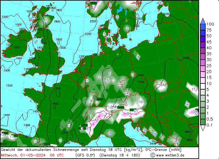
Polo's chart puts it cold on Friday.
A lot of forecasts are putting it 1500m or below by then in the west. The FL appears on a downward slide most of the week to me.
The last 2 seasons in Val/Tignes has seen it stick down to around 2000m with the first real snow either last week or this. The cold should allow the higher resorts to get the snow blowers going (water permitting) on the main thoroughfares.
Cautiously optimistic that the snow falling over the next 72 hours or so in the west will form a base for the higher resorts. The cold snap will certainly help.
But who knows!! The experts here have a better idea than most.
|
|
|
|
|
|
snowHeads are a friendly bunch.
snowHeads are a friendly bunch.
|
Even at these temps, snows already settling in Lac des Vaux, Verbier and above. Expect it to open next weekend!
|
|
|
|
|
|
And love to help out and answer questions and of course, read each other's snow reports.
And love to help out and answer questions and of course, read each other's snow reports.
|
Here’s SLF’s outlook (my bold).
Full avalanche warning in the link.
https://www.slf.ch/en/avalanche-bulletin-and-snow-situation.html#avalanchedanger
” Weather outlook through Monday, 4 November 2019
Several rounds of precipitation are expected to move across Switzerland from the west. Skies will be heavily overcast for the most part, accompanied by foehn-induced bright spells in the eastern regions in particular. Precipitation is anticipated over widespread areas which will be heavy in the southern and western regions on Sunday in particular. The snowfall level will initially lie at 2000 m, subsequently will drop down to approximately 1600 m during the course of the day on Sunday, and lower still in the upper Alpine valleys of Ticino. On Monday the snowfall level will lie between 1600 and 2000 m. The wind will be blowing at moderate to strong velocity from southwesterly to westerly directions.
Between Saturday evening and Monday evening, the following amounts of fresh snow are expected above approximately 2600 m:
- Vaud Alps, Lower Valais, Main Alpine Ridge from Lukmanier Pass into the Bernina region: 50 to 70 cm, on the French border as much as 90 cm;
- Northern Alpine Ridge from the Wildstrubel as far as Furka Pass, Monte Rosa, remaining sectors of the southern flank of the Alps: 30 to 50 cm;
- in the other regions of Switzerland, 15 to 30 cm;
- in the foehn-influenced regions of the north only a few centimetres.
Outlook
On Tuesday, skies are expected to be heavily overcast for the most part and precipitation is anticipated over widespread areas, most of it in the southern regions. The snowfall level will drop to 1200 to 1500 m. On Wednesday, it will presumably remain dry and bright skies are expected intermittently. Temperatures will remain low. The avalanche danger could increase somewhat on Tuesday, subsequently will incrementally diminish on Wednesday.”
|
|
|
|
|
|
|
|
|
|
|
You know it makes sense.
|
|
What lifts do we expect to be turning next week? Close to none? The Austrian Glacier resorts, Tignes and LDA glaciers? Is that it? Bobinch will Verbier be open?
|
|
|
|
|
|
Otherwise you'll just go on seeing the one name:
Otherwise you'll just go on seeing the one name:
|
| 8611 wrote: |
| What lifts do we expect to be turning next week? Close to none? The Austrian Glacier resorts, Tignes and LDA glaciers? Is that it? Bobinch will Verbier be open? |
Looks promising for Lac des Vaux if there’s another day of this and temps stay cold so they can run the canons...
|
|
|
|
|
|
Poster: A snowHead
|
|
Zermatt snow starting to form down to 2000 metres or so. More forecast for the day
|
|
|
|
|
|
Obviously A snowHead isn't a real person
Obviously A snowHead isn't a real person
|
Sweden today

location: https://www.google.com/maps/place/Åreskutan/
snow was down to 1900 meters earlier in the French N.A. perhaps a little bit lower but only a few cms
However the Ecrins have had close to a meter of snow at 3000 meters altitude but with a lot of wind, I can see some people heading out into that but there's going to be some windslab around and there was a weak layer in place before the recent storm.
50 cm on the Grande Motte glacier (Tignes).
|
|
|
|
|
|
Well, the person's real but it's just a made up name, see?
Well, the person's real but it's just a made up name, see?
|
|
|
|
You need to Login to know who's really who.
You need to Login to know who's really who.
|
Most of the Alps above average precipitation, below average temperatures for the next 8 days.
|
|
|
|
|
|
Anyway, snowHeads is much more fun if you do.
Anyway, snowHeads is much more fun if you do.
|
|
|
|
You'll need to Register first of course.
You'll need to Register first of course.
|
@nozawaonsen, blimey that looks great. What altitude? Snow level down to about 1800m overnight around the lake
|
|
|
|
|
|
|
|
@BobinCH, reckon the high point of the Flexenpass must be about 1800m? Do love that moment when the driving rain suddenly switches into white snow on a drive up to the mountains.
Temperatures continue to fall this week with more snow crossing the Alps today into tomorrow and Friday into Saturday.
Lech at 2210m
|
|
|
|
|
|
|
|
| 8611 wrote: |
| What lifts do we expect to be turning next week? Close to none? The Austrian Glacier resorts, Tignes and LDA glaciers? Is that it? Bobinch will Verbier be open? |
Obergurgl officially opens on 14th. The cannons are firing this morning, and they've had a small amount of snow.
Don't forget Kitzbuhel has supposedly been "open" since last month (on the one short north facing run at Pass Thurn with snow farmed and stored there over the summer). https://webtv.feratel.com/webtv/?design=v3&cam=5603&c2=0
|
|
|
|
|
|
You'll get to see more forums and be part of the best ski club on the net.
You'll get to see more forums and be part of the best ski club on the net.
|
Interesting early Nov snow storms, they tend to melt (historically) below 2,500-3,000m from my memory of previous seasons???
I remember early Nov skiing in Tignes with InsideOut skiing where it was snowing heavily down to Tignes Les Boisses @ 1850m but had all melted in a few weeks.
|
|
|
|
|
|
|
|
| nozawaonsen wrote: |
| .........Do love that moment when the driving rain suddenly switches into white snow on a drive up to the mountains.......... |
We ventured out to do exactly that yesterday, driving from home at 1,400m up to the Col du Lautaret 2,053, as cam up there was showing snow.
However, as we left temp was showing +4.5 and only dropped 1 degree in 500m and was light rain as we got out at 1,960m.
The snow was slushy wet and heavy but as we hiked up and where the wind had been active it would hide a tennis ball well which entertained the dogs*.
Then all of a sudden wind picked up temps dropped almost in a second and we were enveloped in the start of a blizzard so we didn't hang around and retreated back to the van.
We're now waiting for the colder temps and snow that is forecast.
I'm not too sure we'll get out on the skis this week for a sortie.
*dog pic in the Serre thread
|
|
|
|
|
|
|
|


