 Poster: A snowHead
|
@Whitegold, Yeah, you picked a winner this year alright 
I'd sooner go to Scotland than Bansko even if it were to ski on rocks.
|
|

|
|
|
|
Obviously A snowHead isn't a real person
Obviously A snowHead isn't a real person
|
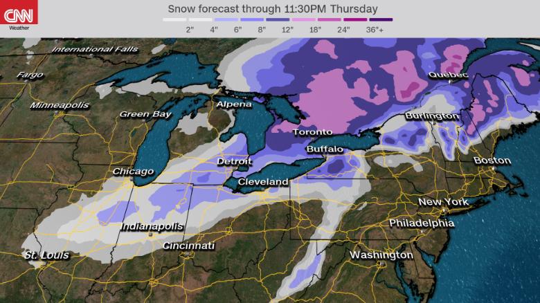
Northeast US due a big puke, up to 2ft.
Killington in the line of fire on Thurs.
|
|
|
|
|
|
Well, the person's real but it's just a made up name, see?
Well, the person's real but it's just a made up name, see?
|
| Whitegold wrote: |
Glencoe is reporting 450cm at the summit.
Scotland is (finally) worth a trip for the Brits.
Bulgaria continues to have a nitemare season.
Snow in the valley at Bansko has all but disappeared. |
ive got a pal doing a winter mountain leader course, intel on the ground is skiing mega at the min up there
|
|
|
|
|
|
You need to Login to know who's really who.
You need to Login to know who's really who.
|
An update from SLF.
“ Observed weather on Wednesday, 26.02.2020
Nocturnal skies in the southern and the eastern regions were partially clear, in the other regions of Switzerland there was snowfall. During the daytime there was persistent snowfall in the northern regions, in the eastern regions showerlike precipitation accompanied by bright intervals. The snowfall level descended swiftly from approximately 1000 m down to low lying areas during the night. In the southern regions it remained mostly dry and quite sunny.
Fresh snow
Above 1400 m:
and furthermost western parts of Lower Valais, northern Alpine Ridge west of Blüemlisalp, Vaud Alps, Fribourg Alps, Glarus Alps, St. Gallen Alps: 25 to 40 cm;
Jura region, remaining parts of the northern flank of the Alps, Gotthard region, remaining parts of the Valais not including Simplon regions and Binntal, northern Grisons: 15 to 25 cm;
in the other regions of Switzerland, less; or else it remained dry.
Temperature
At midday at 2000 m, -8 °C in the northern regions and -6 °C in the southern regions.
Wind
Winds were westerly, subsequently shifting to northwesterly,
initially blowing at strong velocity only in the western regions and at high altitudes in general, strengthening in all regions during the course of the day.
Weather forecast through Thursday, 27.02.2020
During the nighttime hours in the northern regions, there will frequently be snowfall. Precipitation will come to an end from the west during the latter part of the night. Following a brief interim in precipitation, including some bright intervals, snowfall will again set in from the west during the morning. The snowfall level will ascend during the course of the day from the west to approximately 1400 m; in inneralpine regions the snowfall level will remain lower.
Fresh snow
Between Wednesday afternoon and Thursday afternoon above 1400 m:
Lower Valais, northern Alpine Ridge west of the Tödi: 20 to 40 cm;
Jura region, remaining parts of the northern flank of the Alps, remaining parts of Gotthard region, Prättigau: 15 to 25 cm;
in the other regions of Switzerland, 5 to 15 cm over widespread areas;
in the furthermost southern regions it will remain dry.
Temperature
Rapidly ascending temperatures during the course of the day from the northwest; rising by midday to -2 °C at 2000 m in the northwestern regions, to -8 °C in the southeastern regions.
Wind
Winds will shift from northwesterly to southwesterly,
and be blowing at storm strength on the northern flank of the Alps and in general at high altitudes; in other regions at moderate strength;
in the Alpine valleys of the north, increasingly strong foehn wind during the course of the afternoon.
Outlook through Saturday, 29.02.2020
Friday
The snowfall is expected to end during the course of Thursday night. In the northern regions, 10 to 30 cm of fresh snow is anticipated over widespread areas. The snowfall level will once again descend down to low lying areas. In the northern regions it will subsequently be partly sunny, in the southern regions predominantly so, and it will become significantly milder. Winds during the nighttime hours will be blowing initially at strong to storm strength, subsequently at predominantly moderate strength, from northwesterly directions. The avalanche danger levels in outlying terrain away from secured ski runs will remain critical over widespread areas.
Saturday
On Saturday it will be partly sunny. During the afternoon in the western regions, light precipitation will once again set in. The snowfall level will lie at approximately 1400 m. A strong to storm-strength southwesterly wind will be blowing. The avalanche situation will remain critical in the regions where snowfall has been heaviest in outlying terrain away from secured ski runs.“

|
|
|
|
|
|
Anyway, snowHeads is much more fun if you do.
Anyway, snowHeads is much more fun if you do.
|
Winds are going to be swinging round quite a bit.

Could see gusts between 130-150kmh at times at altitude over the next few days.
|
|
|
|
|
|
You'll need to Register first of course.
You'll need to Register first of course.
|
ECM continues to suggest significant snow south of the main ridge early next week. Doesnt seem to me that it will be a retour d'est more that the main centres of precipitation will be north of the low as it tracks across northern Italy rather than swinging all the way round back east. If it happens along these lines it should bring a decent fall to the Dolomites and Kärnten. GFS is far less keen on the significant precipitation.

|
|
|
|
|
|
|
|
|
@munich_irish, what sort of freezing level for the Dolomites region though? GFS / GEM going for quite high rain limits (>1500m).
|
|
|
|
|
|
|
|
|
@denfinella, There is a difference between the latest ECM and GFS runs for early next week. ECM suggests significant snowfall for pretty much the entire Italian alps Monday / Tuesday whereas GFS suggests a lot less. Both models suggest the mild conditions south of the alps will continue but GFS suggests getting cooler from early next week. There is an animation of the ECM forecast here https://wxcharts.com/gifs/Tpbgy01wx4.gif (hope it works)
|
|
|
|
|
|
You'll get to see more forums and be part of the best ski club on the net.
You'll get to see more forums and be part of the best ski club on the net.
|
|
Up to 80cm of fresh snow in the Mont Blanc/Tarentaise/Beaufortain areas but figures dropping off in the south of the Savoie and Isere (10-20cm only). Very strong/storm force westerly winds and HIGH avalanche risk.
|
|
|
|
|
|
|
|
|
|
|
snowHeads are a friendly bunch.
snowHeads are a friendly bunch.
|
|
And halt please, after this snowfall, for 1 week only. My wife has(and I), have seemingly skied in nothing but whiteouts the last 2 years. A bit on sunny piste cruising is called for.
|
|
|
|
|
|
And love to help out and answer questions and of course, read each other's snow reports.
And love to help out and answer questions and of course, read each other's snow reports.
|
|
Looks like small signs of “a resuming services normal “ dry and warming towards the end of next week .
|
|
|
|
|
|
|
|
|
|
|
You know it makes sense.
|
@SkiG, we should ski the same resort each year. That would fix it! 
|
|
|
|
|
|
Otherwise you'll just go on seeing the one name:
Otherwise you'll just go on seeing the one name:
|
|
I'm off to Verbier on the 4th. Keep it coming!
|
|
|
|
|
|
Poster: A snowHead
|
|
Chucking it down in Cham. About 5cms/hour. Snowblower may have to be employed.
|
|
|
|
|
|
Obviously A snowHead isn't a real person
Obviously A snowHead isn't a real person
|
| under a new name wrote: |
| Chucking it down in Cham. About 5cms/hour. Snowblower may have to be employed. |
Can you blow it towards the east, please? There's not much going on at all here.
|
|
|
|
|
|
Well, the person's real but it's just a made up name, see?
Well, the person's real but it's just a made up name, see?
|
| Scarlet wrote: |
| under a new name wrote: |
| Chucking it down in Cham. About 5cms/hour. Snowblower may have to be employed. |
Can you blow it towards the east, please? There's not much going on at all here. |
Beat me to it. The Cham town centre webcam looks awesome.
https://www.chamonix.net/english/webcams/chamonix-town
Please please drift over to Austria 
|
|
|
|
|
|
You need to Login to know who's really who.
You need to Login to know who's really who.
|
|
|
|
Anyway, snowHeads is much more fun if you do.
Anyway, snowHeads is much more fun if you do.
|
It is actually snowing a bit here now, but it's coming in sideways 
|
|
|
|
|
|
You'll need to Register first of course.
You'll need to Register first of course.
|
|
Seems to be lots of conflicting forecasts for Meribel for the next 5 days, anything from a light top up to days of heavy snow from tomorrow on
|
|
|
|
|
|
|
|
|
|
|
|
|
|
Zermatt Bahnhofplatz covered. They clear this faster than anywhere, so a good sign for todays fall.
|
|
|
|
|
|
You'll get to see more forums and be part of the best ski club on the net.
You'll get to see more forums and be part of the best ski club on the net.
|
|
Quite heavy snow in Frankfurt at the moment. I am trying to fly home and our pilot aborted the takeoff after taking a look at the runway. I would say it’s slushy...
Last edited by You'll get to see more forums and be part of the best ski club on the net. on Thu 27-02-20 23:58; edited 1 time in total
|
|
|
|
|
|
|
|
|
Good to see Cham valley white again.
|
|
|
|
|
|
snowHeads are a friendly bunch.
snowHeads are a friendly bunch.
|
|
Säntis so far top of the league with gusts up to 167.8kmh.
|
|
|
|
|
|
And love to help out and answer questions and of course, read each other's snow reports.
And love to help out and answer questions and of course, read each other's snow reports.
|
|
|
|
|
|
SLF‘s update from yesterday evening.
“Observed weather on Thursday, 27.02.2020
During the night in the northern regions more than anywhere else, there was snowfall. In the morning hours in the southern and eastern regions it was quite sunny to start with, subsequently cloud cover moved in and precipitation again set in. The snowfall level ascended to nearly 1400 m during the afternoon.
Fresh snow
Between Tuesday morning and Thursday afternoon, above 1400 m:
Lower Valais not including Arolla, northern Grisons, northern flank of the Alps: mostly 40 to 60 cm;
Jura region, remaining parts of the Valais, remaining parts of the Gotthard region, upper valleys of Maggia, northern Grisons: 15 to 30 cm;
in the other regions of Switzerland, less; in the furthermost regions of the south it remained dry.
Temperature
Temperatures increased starting in the west, at midday at 2000 m to between -2 °C in the western regions and -8 °C in the eastern regions.
Wind
During the night blowing at moderate to strong velocity from westerly to northweasterly directions;
during the daytime becoming increasingly strong in velocity, storm strength, from the southwest; in the Alpine valleys of the north, strong-velocity foehn wind.
Weather forecast through Friday, 28.02.2020
During the night in the northern regions, frequent snowfall is anticipated. The precipitation will come to an end in the latter part of the nocturnal hours in the western regions, in the early morning hours in the eastern regions. Subsequently it will become quite sunny, before renewed cloud cover moves in from the west during the afternoon. In the southern regions it will be quite sunny. The snowfall level will swiftly descend from 1400 m down to low lying areas.
Fresh snow
Between Thursday afternoon and Friday morning above 1400 m:
northern Alpine Ridge east of the Finsteraarhorn, Prättigau, Silvretta: 20 to 40 cm;
in the other regions of Switzerland, 10 to 20 cm over widespread areas;
on the southern flank of the Alps, southern Goms, central Grisons, Engadine: less; or else it will remain dry.
Temperature
Temperatures will rise during the course of the day starting in the west: at midday at 2000 m to between -4 °C in the western regions and -10 °C in the eastern regions.
Wind
On Thursday evening, a strong to storm-strength southwesterly wind will still be blowing, subsequently shifting to northerly-to-northwesterly;
during the nighttime hours blowing at strong velocity in the southern regions at storm strength until midday;
in the other regions of Switzerland winds will be blowing predominantly at moderate strength.
Outlook through Sunday, 01.03.2020
Saturday
On Saturday it will be partly sunny to begin with. Subsequently cloud cover is expected to move in from the west. During the afternoon in the western and the southern regoins, a small amount of snowfall is anticipated above 1400 m. As a result of foehn windstorms it will be mild in the northern regions. Avalanche danger levels will remain critical in outlying terrain away from secured ski runs.
Sunday
On Saturday night, snowfall is expected over widespread areas above 1000 m. the daytime on Sunday, skies will be predominantly overcast in the northern regions, accompanied by some sunny intervals; in the southern regions it will be quite sunny. Temperatures will again descend significantly. Winds will be blowing at strong velocity from westerly directions. Avalanche danger levels are not expected to change significantly.“
|
|
|
|
|
|
You know it makes sense.
|
|
More snow incoming on Saturday, but rain to 1800 meters and high winds !
|
|
|
|
|
|
Otherwise you'll just go on seeing the one name:
Otherwise you'll just go on seeing the one name:
|
ECM still very keen on substantial snowfall overnight Monday / Tuesday in the south central & eastern alps, GFS absolutely not interested. Anyone got an idea why?

|
|
|
|
|
|
Poster: A snowHead
|
@munich_irish, GFS OP isn't predicting that low over NW Italy but I'd like it if they both came to an agreement of it being there!
Looking at GFS for the SW alps, there is lots of signal for precipiation from the ensembles but it's not being picked up by the OP.
|
|
|
|
|
|
Obviously A snowHead isn't a real person
Obviously A snowHead isn't a real person
|
Actually it was there in the 12z Control run and is also there in the 18z Op Just unrolling.

|
|
|
|
|
|
Well, the person's real but it's just a made up name, see?
Well, the person's real but it's just a made up name, see?
|
|
Maybe I was looking at an old run on GFS as the latest run also seems to be fairly snowy, with a low pressure area tracking across northern Italy. Good news for the Dolomites.
|
|
|
|
|
|
You need to Login to know who's really who.
You need to Login to know who's really who.
|
That’s quite a La Grave forecast for next week!

|
|
|
|
|
|
Anyway, snowHeads is much more fun if you do.
Anyway, snowHeads is much more fun if you do.
|
|
|
|
You'll need to Register first of course.
You'll need to Register first of course.
|
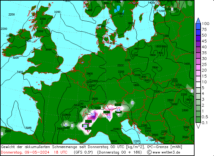
00z GFS take on snowfall out to next weekend.
|
|
|
|
|
|
|
|
Cropped up in the last couple of GFS runs.

ECM not interested yet. Let‘s see.
|
|
|
|
|
|
|
|
|
Any idea what 2nd week of March is looking like for Grand Massif area. We get there next Friday 6th?
|
|
|
|
|
|
You'll get to see more forums and be part of the best ski club on the net.
You'll get to see more forums and be part of the best ski club on the net.
|
I'll let you know Tuesday! 
|
|
|
|
|
|
|
|
|
@snowmam, looking like potentially quite unsettled over that weekend (with fresh snow) then possibly calming down (with more sun). But at that range that is very low confidence.
|
|
|
|
|
|
|
|


