Poster: A snowHead
|
| Peter S wrote: |
| Guess this is what climate change looks like for the alps ? |
It could be, but I think it's probably too early to tell. Most climate models suggest warmer temps and lower precipitation overall, but with regional variability and low confidence.
The long-term warming trend will very likely continue, but snowfall and even temperatures in the Alps (considering the latitude and orientation) are largely driven by global circulation patterns. The question is whether or not the increase in oceanic and atmospheric heat content will result in recurring patterns that favor or hinder European snowfall.
|
|

|
|
|
|
Obviously A snowHead isn't a real person
Obviously A snowHead isn't a real person
|
|
Anyone care to give me their gut feelings for 3 valleys next week?... was gearing up for a week of piste skiing in the sun but now it all looks quite unsettled from midweek ish?
|
|
|
|
|
|
Well, the person's real but it's just a made up name, see?
Well, the person's real but it's just a made up name, see?
|
|
|
|
You need to Login to know who's really who.
You need to Login to know who's really who.
|
Well, I've read numerous postings by credible persons on weather fora, stating that the effect of climate change will be
more frequent blocked pressure patterns.
Logic is
-overall temperature rise
-but larger increase over north and southpole
-so less temperature gradient between equator and pole
-therefore the jetstream will meander more
-therefore less zonal flow (west -> east) and more non-zonal (i.e. south -> north & north -> south) flow
-because of this, we will have more persistent location of high pressure and low pressure
|
|
|
|
|
|
Anyway, snowHeads is much more fun if you do.
Anyway, snowHeads is much more fun if you do.
|
| altaski8 wrote: |
| Peter S wrote: |
| Guess this is what climate change looks like for the alps ? |
It could be, but I think it's probably too early to tell. Most climate models suggest warmer temps and lower precipitation overall, but with regional variability and low confidence.
The long-term warming trend will very likely continue, but snowfall and even temperatures in the Alps (considering the latitude and orientation) are largely driven by global circulation patterns. The question is whether or not the increase in oceanic and atmospheric heat content will result in recurring patterns that favor or hinder European snowfall. |
Global boiling is already smashing the European Alps and Pyrenees.
Snowfall across the Alps is down 10-30% in 50 years.
Glaciers have -80% melted in the Pyrenees since WW1.
Lake in Zell am See is unfrozen in the peak of winter.
Chamonix town is rarely white.
Finding deep, light pow across Europe is getting harder and harder every year.
|
|
|
|
|
|
You'll need to Register first of course.
You'll need to Register first of course.
|
| Whitegold wrote: |
| altaski8 wrote: |
| Peter S wrote: |
| Guess this is what climate change looks like for the alps ? |
It could be, but I think it's probably too early to tell. Most climate models suggest warmer temps and lower precipitation overall, but with regional variability and low confidence.
The long-term warming trend will very likely continue, but snowfall and even temperatures in the Alps (considering the latitude and orientation) are largely driven by global circulation patterns. The question is whether or not the increase in oceanic and atmospheric heat content will result in recurring patterns that favor or hinder European snowfall. |
Global boiling is already smashing the European Alps and Pyrenees.
Snowfall across the Alps is down 10-30% in 50 years.
Glaciers have -80% melted in the Pyrenees since WW1.
Lake in Zell am See is unfrozen in the peak of winter.
Chamonix town is rarely white.
Finding deep, light pow across Europe is getting harder and harder every year. |
No question average annual temperatures are warming. In marginal years, that's going to result in green or brown mountain valleys and non-frozen lakes. And it has accelerated the melting of glaciers that were already in long-term decline.
But warmer temperatures do not always result in less snowfall. It is possible to have higher temperatures and higher precipitation. Particularly in mountainous areas, this could result in an increase in annual snowfall. But, like you say, finding accessible, light powder will probably get more difficult regardless.
|
|
|
|
|
|
|
|
| altaski8 wrote: |
No question average annual temperatures are warming.. But warmer temperatures do not always result in less snowfall. It is possible to have higher temperatures and higher precipitation. Particularly in mountainous areas, this could result in an increase in annual snowfall. But, like you say, finding accessible, light powder will probably get more difficult regardless. |
Not only are temperatures (average over the year) going up.
In addition to this, we will see more often, that high pressure areas stay in 1 place for weeks on end.
Blocked pressure pattern.
As a result of this:
-more frequent high pressure block
-so on average, less precipitation
-and at the same time, some regions have an increase in precipitation, due to change in flow patterns
What you see is a strong reduction in the number of "nordstau" situations (snow on the northern and eastern flanks of the Alps).
And an increase in the number of "retour d'est" situations (Piemonte, Alpes du Sud).
I can still remember, 15 years ago (teletext era), the via lattea are used to have 20 cms on bottom slopes and 40 on top slopes for most of the season.
Now they have multiple retour d'est per season, and thus almost every season good snow cover.
The number of proper "nordstau" situations in Germany and Austria has decreased enormously over the same last 15 years.
As a result of this, the part of Austria to the northeast of the alpine ridge misses out on the big snow. No nordstau, no snow in Tyrol.
Arlberg is a bit of an exception, because snow from the west still reaches them.
But once past the Arlberg, snow quantities are down dramatically compared to 10-20 years ago.
|
|
|
|
|
|
|
|
| Onnem wrote: |
| altaski8 wrote: |
No question average annual temperatures are warming.. But warmer temperatures do not always result in less snowfall. It is possible to have higher temperatures and higher precipitation. Particularly in mountainous areas, this could result in an increase in annual snowfall. But, like you say, finding accessible, light powder will probably get more difficult regardless. |
Not only are temperatures (average over the year) going up.
In addition to this, we will see more often, that high pressure areas stay in 1 place for weeks on end.
Blocked pressure pattern.
As a result of this:
-more frequent high pressure block
-so on average, less precipitation
-and at the same time, some regions have an increase in precipitation, due to change in flow patterns
What you see is a strong reduction in the number of "nordstau" situations (snow on the northern and eastern flanks of the Alps).
And an increase in the number of "retour d'est" situations (Piemonte, Alpes du Sud).
I can still remember, 15 years ago (teletext era), the via lattea are used to have 20 cms on bottom slopes and 40 on top slopes for most of the season.
Now they have multiple retour d'est per season, and thus almost every season good snow cover.
The number of proper "nordstau" situations in Germany and Austria has decreased enormously over the same last 15 years.
As a result of this, the part of Austria to the northeast of the alpine ridge misses out on the big snow. No nordstau, no snow in Tyrol.
Arlberg is a bit of an exception, because snow from the west still reaches them.
But once past the Arlberg, snow quantities are down dramatically compared to 10-20 years ago. |
I don't personally disagree, but this is still a subject of disagreement among climatologists. You talk as if future weather patterns are a certainty. We don't know for sure if high level blocking will increase or decrease and how that will affect local weather patterns. Even if the past few decades show certain weather pattern trends, we cannot know if those trends will continue or are phases of longer-term cycles.
|
|
|
|
|
|
You'll get to see more forums and be part of the best ski club on the net.
You'll get to see more forums and be part of the best ski club on the net.
|
|
Last winter also had an incredible sequence of nordstau events in January. There was very deep snow cover in the northern Alps, which lasted into late Spring despite periods of warm weather. I think it's dangerous to draw conclusions based on small sample sizes.
|
|
|
|
|
|
|
|
|
|
|
snowHeads are a friendly bunch.
snowHeads are a friendly bunch.
|
[quote="altaski8"]
| Onnem wrote: |
I don't personally disagree, but this is still a subject of disagreement among climatologists. You talk as if future weather patterns are a certainty. We don't know for sure if high level blocking will increase or decrease and how that will affect local weather patterns. Even if the past few decades show certain weather pattern trends, we cannot know if those trends will continue or are phases of longer-term cycles. |
Normally I post my own line of thinking.
But this time is was something I parrot-ed (is that a word?) from a weather forum, statement by a serious dutch meteorologist.
And the line of reasoning is entirely logic, and supported by long term facts.
1. Global temperature (average of the world) is rising due to global warming.
2. Increase of average temperature on the poles, is much much stronger than on the equator.
3. Due to this, less temperature and pressure gradient (NAO).
4. Due to this, the jetstream over Europe that normally is a zonal flow (west-east) is losing speed, and meandering. Just like a river when the valley becomes less steep.
5. Due to this, more often and more persistent high pressure over continental europe.
6. Due to this, less often western flow (less precipitation) and more often southern flow.
What is even more scary, is what -could- happen to ocean flow pattern in the Atlantic.
Because of the gulfstream, temperatures in Europe are much balmier than in the US.
Valencia is on the same latitude as New York, but the climate is entirely different.
Imagine what happens when the gulf stream becomes less strong....
There is already some evidence of this, but nothing very conclusive yet...
|
|
|
|
|
|
And love to help out and answer questions and of course, read each other's snow reports.
And love to help out and answer questions and of course, read each other's snow reports.
|
|
Onnem, you mentioned retour d'est patterns benefiting the Via Lattea. Am I right in thinking that they would in general benefit all of the Italian resorts, which are to the south and/or east of the main alpine ridge? I'm thinking particularly of the Monterosa area, but others as well.
|
|
|
|
|
|
|
|
[quote="altaski8"]
| ribblevalleyblue wrote: |
| altaski8 wrote: |
Good post denfinella.
Piste skiers don't need much except sunshine and alcohol.
Please elaborate @altaski8, all piste skiers need alcohol? |
| mountainaddict wrote: |
| Quote: |
| all piste skiers need alcohol? |
Do bears go about their business in the woods?  |

European skiing seems to be largely centered around the on-mountain culinary experience and frequent ski breaks replete with espresso, beer, wine, or aperol. There is always an alcoholic beverage (or 3) on every table, which would seem unusual in the US (where people drink a lot more water in restaurants, because it's free). The apres also starts early and ends late. North Americans don't do apres ski very well. European resort reviews always mention the hüttes, alms, or rifugios. It reminds me of Floridians discussing a Caribbean cruise.
North American skiers like to drink alcohol too. But it is secondary to skiing. On-mountain food options tend to be limited and expensive. So most, excluding the truly wealthy, pack a sandwich and eat it in the base lodge. The focus is on the terrain and the powder. And considering the exorbitant price of lift tickets these days, there is no time to focus on anything else. |
North American cafeterias on mountain serve mediocre food at premium prices. There’s also nowhere to sit because couples and families of 2-4 take up 8 person tables and spread their crap over the entire area. I enjoy the on mountain food in the alps it’s much more refined. However, it consumes a lot of time in the ski day. This is offset by the lifts operating an hour later in the day.
|
|
|
|
|
|
You know it makes sense.
|
| under a new name wrote: |
| @horgand, I’d be surprised if it’s not a lot better than you are expecting. |
Thanks UANN, I'm all up to be pleasantly surprised by the weather tbh. As per the old adage prepare for the worst but still looking for the best  ) )
|
|
|
|
|
|
Otherwise you'll just go on seeing the one name:
Otherwise you'll just go on seeing the one name:
|
| Ptspeak wrote: |
North American cafeterias on mountain serve mediocre food at premium prices. There’s also nowhere to sit because couples and families of 2-4 take up 8 person tables and spread their crap over the entire area. I enjoy the on mountain food in the alps it’s much more refined. However, it consumes a lot of time in the ski day. This is offset by the lifts operating an hour later in the day. |
Yeah ski food in Europe is better, and a better value overall. But no, the lifts don't operate later. If anything, they tend to stop running earlier due to shorter days at higher latitude during the winter. The sun angle is higher and day length is longer in NA, esp. in the US.
If only we could teach Europeans to conduct themselves more civilly in the lift lines (or have a better system to coral them in line), the European ski experience would be truly wonderful.
|
|
|
|
|
|
Poster: A snowHead
|
| J2R wrote: |
| Onnem, you mentioned retour d'est patterns benefiting the Via Lattea. Am I right in thinking that they would in general benefit all of the Italian resorts, which are to the south and/or east of the main alpine ridge? I'm thinking particularly of the Monterosa area, but others as well. |
Basically there's 3 big types of southern flows that give massive amounts of snow on the western and eastern end of the Alpine ridge.
Retour d'est is most famous of the 3. Direction of retours d'est can differ a bit, and with the direction also where most of the precipitation lands.
Normally most of the epicentre is between Monte Viso (Pontechianale) and eastern end of Monte Rosa (Macugnaga).
There's also a second type (don't know the name) which is more from the south.
Then most falls further to the right, in the area between Monte Rosa and Ticino (Ayas - Macugnaga - Bosco Gurin - Madesimo).
And then there's the third, which dumps on the border between Italy and Slovenia; to the far right of the boot.
Sella Nevea and Bovec Kanin. Often have more than 5 meters snow depth end of April...
Last edited by Poster: A snowHead on Fri 24-01-20 6:46; edited 1 time in total
|
|
|
|
|
|
Obviously A snowHead isn't a real person
Obviously A snowHead isn't a real person
|
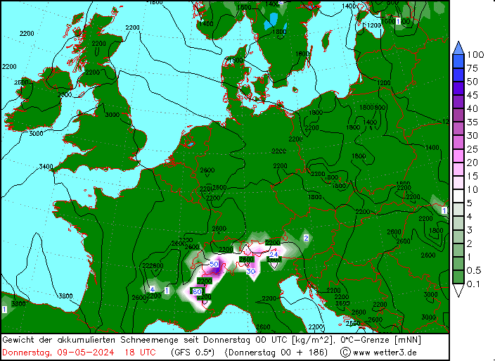
This is the 18z GFS snapshot. As ever the numbers shouldn’t be taken too seriously, but it gives a feel for the current state of play out to Friday 31 January.
|
|
|
|
|
|
Well, the person's real but it's just a made up name, see?
Well, the person's real but it's just a made up name, see?
|
That 18z GFS would work for a lot of the Alps... would certainly add to the base. But there's not much margin to the west between the mountains and a warm Atlantic airmass. The 500mb energy swings through fairly far N and E (between the 27th and the 31st) - close enough to bring significant precipitation this run, but it's not a setup that makes you feel comfortable. There's been a lot more modeled snowfall this winter than actual snowfall. But I'd definitely take this run. It has some support from other mid-range guidance.
Unfortunately that run also brings a period of warm, rainy conditions in early February. But that's way out there and subject to change.
|
|
|
|
|
|
You need to Login to know who's really who.
You need to Login to know who's really who.
|
|
|
|
Anyway, snowHeads is much more fun if you do.
Anyway, snowHeads is much more fun if you do.
|
|
@Vrotswaffff, look on the bright side, there might be some enormous French strike and you might not make it out there at all!
|
|
|
|
|
|
You'll need to Register first of course.
You'll need to Register first of course.
|
|
|
|
|
|
| nozawaonsen wrote: |
| @Vrotswaffff, look on the bright side, there might be some enormous French strike and you might not make it out there at all! |
The level of coordination at Grenoble Airport usually I dont think I would be able to tell the difference!
Out of interest how certain is this warm spell at the end of the month now, are the ensembles pretty certain on it?
|
|
|
|
|
|
|
|
|
A cooler period around 28/29 January is looking increasingly likely as is a milder spell around 01/02 February (though not necessarily with precipitation). After that things split quite a bit, the op run was an outlier in taking it warmer still, the majority of the ensembles went back towards seasonal temperatures. That said much of that is 8 or 9 days out so I would not have much confidence in it. Still time to change.
|
|
|
|
|
|
You'll get to see more forums and be part of the best ski club on the net.
You'll get to see more forums and be part of the best ski club on the net.
|
|
|
|
|
|
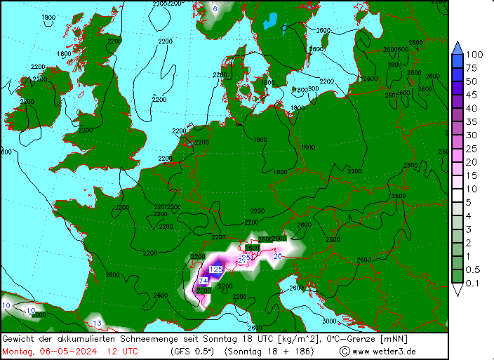
@Vrotswaffff, the map above doesn't show snow line.
It shows the 0°C isotherm on Fri 31st only along with the total accumulated snowfall from now until Fri 31st.
The snow line over that period isn't something you can find out from that map - it could be 0m or 3000m or anywhere in between. (In truth, it'll probably vary between <1000m and 1500m+.)
|
|
|
|
|
|
snowHeads are a friendly bunch.
snowHeads are a friendly bunch.
|
| denfinella wrote: |
@Vrotswaffff, the map above doesn't show snow line.
It shows the 0°C isotherm on Fri 31st only along with the total accumulated snowfall from now until Fri 31st.
The snow line over that period isn't something you can find out from that map - it could be 0m or 3000m or anywhere in between. (In truth, it'll probably vary between <1000m and 1500m+.) |
Ohhhh ok that makes some more sense!
Thank you very much, I try and become an amateur armchair meteorologist at this time of year with variable success
|
|
|
|
|
|
And love to help out and answer questions and of course, read each other's snow reports.
And love to help out and answer questions and of course, read each other's snow reports.
|
|
@nozawaonsen, praise the Lord. Posts about possible weather.
|
|
|
|
|
|
|
|
|
|
|
You know it makes sense.
|
|
Am I correct in interpreting that the 00Z run has lowered the freezing levels for the front that moves in on Tuesday? Assume this could still flit up and down as runs progress.
|
|
|
|
|
|
Otherwise you'll just go on seeing the one name:
Otherwise you'll just go on seeing the one name:
|
@Garioch, yes (for the GFS run) and increased precipitation amounts, particularly if you're looking at the NW Alps.
The Op run is a bit colder and snowier than the rest of the ensemble, so Snowforecast etc. might look a bit optimistic this morning.
|
|
|
|
|
|
Poster: A snowHead
|
|
|
|
Obviously A snowHead isn't a real person
Obviously A snowHead isn't a real person
|
|
|
|
Well, the person's real but it's just a made up name, see?
Well, the person's real but it's just a made up name, see?
|
|
|
|
You need to Login to know who's really who.
You need to Login to know who's really who.
|
Based on the UK, CMC, GFS and ECMWF it looks like the Alps will be riding the edge of airmasses between roughly the 27th and 31st. That looks like it will keep things active in that period at least. But I would like to see everything shift slightly further southwest (cooler and wetter). Right now model consensus is relatively warm with some of the moisture and vorticity swinging just north of the Alps. But the trajectory has the potential to bring a lot of Atlantic moisture. The mid-range could be a period of high QPF and potentially heavy high mountain snows - particularly for the W and NW Alps.
Early Feb. looks a little warm on all guidance right now.
|
|
|
|
|
|
Anyway, snowHeads is much more fun if you do.
Anyway, snowHeads is much more fun if you do.
|
| Onnem wrote: |
| altaski8 wrote: |
No question average annual temperatures are warming.. But warmer temperatures do not always result in less snowfall. It is possible to have higher temperatures and higher precipitation. Particularly in mountainous areas, this could result in an increase in annual snowfall. But, like you say, finding accessible, light powder will probably get more difficult regardless. |
What you see is a strong reduction in the number of "nordstau" situations (snow on the northern and eastern flanks of the Alps).
And an increase in the number of "retour d'est" situations (Piemonte, Alpes du Sud).
I can still remember, 15 years ago (teletext era), the via lattea are used to have 20 cms on bottom slopes and 40 on top slopes for most of the season.
Now they have multiple retour d'est per season, and thus almost every season good snow cover.
The number of proper "nordstau" situations in Germany and Austria has decreased enormously over the same last 15 years.
As a result of this, the part of Austria to the northeast of the alpine ridge misses out on the big snow. No nordstau, no snow in Tyrol.
Arlberg is a bit of an exception, because snow from the west still reaches them.
But once past the Arlberg, snow quantities are down dramatically compared to 10-20 years ago. |
Do you have any data on this? I'd be interested to see it. Probably best to exclude this season (no real Nordstau so far) and last season (Nordstau after Nordstau after Nordstau) as outliers.
My (anecdotal) perception is that, yeah Arlberg gets the most snow as as it can get snow from multiple directions. But eastern Austria (Oberösterreich, Salzkammergut, etc) always seems to me (again, obviously anecdotal) to get more snow and to have more snow sitting in the valley during the early part of the winter (Dec-end of Feb) than Tyrol and western Austria (but that the season is noticeably shorter too). And similar to Japan (where forecast of 2cm can easiyl mean 30), I often find those zones get significantly more snow than the forecasts predict.
Even now, Windischgarsten is white in the valley at 602m: https://www.bergfex.com/sommer/windischgarsten/webcams/c7122/
But I'd genuinely be interested to see any data on the frequency of Nordstaus! Not in an attempt to prove/dis-prove anything, just to learn.
|
|
|
|
|
|
You'll need to Register first of course.
You'll need to Register first of course.
|
[quote="clarky999"]
| Onnem wrote: |
My (anecdotal) perception is that, yeah Arlberg gets the most snow as as it can get snow from multiple directions. But eastern Austria (Oberösterreich, Salzkammergut, etc) always seems to me (again, obviously anecdotal) to get more snow and to have more snow sitting in the valley during the early part of the winter (Dec-end of Feb) than Tyrol and western Austria (but that the season is noticeably shorter too). And similar to Japan (where forecast of 2cm can easiyl mean 30), I often find those zones get significantly more snow than the forecasts predict.
Even now, Windischgarsten is white in the valley at 602m |
That area around Windischgarsten and just southwest of there is a real snow magnet despite modest elevations. The terrain really wrings out any available moisture on upper level winds with any kind of northerly component.
|
|
|
|
|
|
|
|
EC monthly again is nothing to get excited about. The same outlook more or less as January deep in to February. Lows going more to the south in the next week, but then back to northern Jet with warm and wet weather in Scandinavia and High above the central parts of the continent. Warmer than normal weather for the whole continent. AO and NAO forecast supports this development. I personally think that the GFS 06 is the best forecast for the next 15 days.
The winter season so far has been really special. Southern Norway should have benefited from this kind of weather set up with lots of lows, like in 2015 and 2008. However, the weather is just too warm (global warming?). Finland has had the warmest January in 100 years. The strong polar vortex has just kept the jet stream in a very strong flow with almost no diversion in Europe so far in January. And dissapointingly, it seems to last into February.
Hopefully, the last part of the winter will change and we will see a southernly jet like in November. I am going on 3 weeks road trip in the Alps in March and was hoping to go to many small places that I have not visited before. But if things are not changing, glacier skiing seems to be the solution in March.
|
|
|
|
|
|
|
|
| altaski8 wrote: |
| Ptspeak wrote: |
North American cafeterias on mountain serve mediocre food at premium prices. There’s also nowhere to sit because couples and families of 2-4 take up 8 person tables and spread their crap over the entire area. I enjoy the on mountain food in the alps it’s much more refined. However, it consumes a lot of time in the ski day. This is offset by the lifts operating an hour later in the day. |
Yeah ski food in Europe is better, and a better value overall. But no, the lifts don't operate later. If anything, they tend to stop running earlier due to shorter days at higher latitude during the winter. The sun angle is higher and day length is longer in NA, esp. in the US.
If only we could teach Europeans to conduct themselves more civilly in the lift lines (or have a better system to coral them in line), the European ski experience would be truly wonderful. |
I have had a different experience. EK and 3V both run lifts until 5 I’ve skied the Face at Val d’Isere and been on mountain at 5:15. Right now whistler is closing at 3. The USA does stay open until 4-4:30 but usually one or two. I don’t really need a liftiie to tell me how to load a lift or line up. It’s just my opinion.
|
|
|
|
|
|
You'll get to see more forums and be part of the best ski club on the net.
You'll get to see more forums and be part of the best ski club on the net.
|
|
@Ptspeak, the US v Europe catering/lift discussion is great, but can I gently suggest that you open a separate thread for it? It’s an interesting subject just a bit (lot) off topic.
|
|
|
|
|
|
|
|
[quote="Ptspeak"]
| altaski8 wrote: |
I don’t really need a liftiie to tell me how to load a lift or line up. It’s just my opinion. |
Yeah you do. Really. Lift seats are constantly unused and wasted, adding to larger and longer lift lines. A quad lift should have 4 people on it, not 2... unless there is no line. But I constantly see couples insisting on private rides. And what's worse, you have to really fight for your position in line. Even adults are extremely aggressive in line - there is no courtesy or decently at all. And people are constantly pushing you from behind even when there is nowhere to go. Honestly it's embarrassing.
|
|
|
|
|
|
|
|