The anticyclone stays centred over England the next 5 days giving us great dry weather but allowing artic air to sink down to our east right, into Central Europe.
Only a bit of snow will probably creep across into the Dolomites but I suspect pistes are already good there because they were not saturated by rain in December.
Wrap up warm from tomorrow.
Well, the person's real but it's just a made up name, see?
Well, the person's real but it's just a made up name, see?
nozawaonsen wrote:
ECM 00z FI interesting. A more general outbreak of cold across Europe with snow pushing into the west.
Obviously a bit far out for now. But worth keeping an eye on.
Great work as always Nozawa.
It’s just frustrating that for those of us wanting snow in the West that it always just seems close enough to touch in FI then fizzles out.
I won’t lie, I’m a bit jealous of those currently in Austria or about to head off. Have fun anyway
Crikey. This thread is going off piste. I click on it and read it to read about weather. I've just been forced to read a page of nonsense. Let's keep it on topic guys and girls. The weather is already making me angry enough without arguments about 'snowsure' and the like.
You'll get to see more forums and be part of the best ski club on the net.
You'll get to see more forums and be part of the best ski club on the net.
*sigh* With two weeks leave invested in France for January this horrid pattern (for western alps) is very frustrating!
Ski the Net with snowHeads
Ski the Net with snowHeads
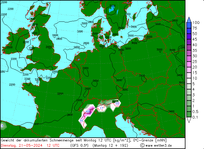
I'm off to the Salzburgerland as from Sat 5th, but now starting to worry that there might be too much snow...that 237kg/m2 precip figure sits right where I'm heading, so up to 237cm snow..8ft??!! I know it's a headline figure, but still, any thoughts??
Could they be closing large parts of resorts until they can secure it all??
Last edited by Ski the Net with snowHeads on Tue 1-01-19 21:26; edited 2 times in total
snowHeads are a friendly bunch.
snowHeads are a friendly bunch.
God, don't say that!
And love to help out and answer questions and of course, read each other's snow reports.
And love to help out and answer questions and of course, read each other's snow reports.
@luigi, main thought is it is unlikely to be that much. However, with strong winds and heavy snow to low levels there could be some disruption.
So if you're just off somewhere snowy come back and post a snow report of your own and we'll all love you very much
So if you're just off somewhere snowy come back and post a snow report of your own and we'll all love you very much
Jenniper wrote:
God, don't say that!
BBC Weather has heavy snow and hovering around zero at Salzburg airport on Sat too!
@luigi, main thought is it is unlikely to be that much. However, with strong winds and heavy snow to low levels there could be some disruption.
Hoping not too much travel disruption.
Bergfex is calling for 140cm at top of Saalbach, similar at Zell, but I guess that's coming over 5 days, roughly a foot of snow a day, so has time to get bashed and settle down. The wooded terrain in that region isn't that conducive to avalanche risk either.
The Bergfex written forecast for Salzburgerland on Sat reads thus (thanks to Google Translate):
On Saturday it stays cloudy all day. It's snowing hard. In very low altitudes, the snowfall gradually turns into rain.
Sounds hopeful for a little less travel disruption, as Salzburg Airport is about as low altitude as you can go in the province. I don't mind encountering a few heavy flakes on the way up to resort though!
Poster: A snowHead
Poster: A snowHead
@luigi, even heavy snow probably won't disturb the airport that much. I don't about SBG, but Innsbruck airport can clear a runway of snow in 8 minutes, and I assume SBG has similar capabilities.
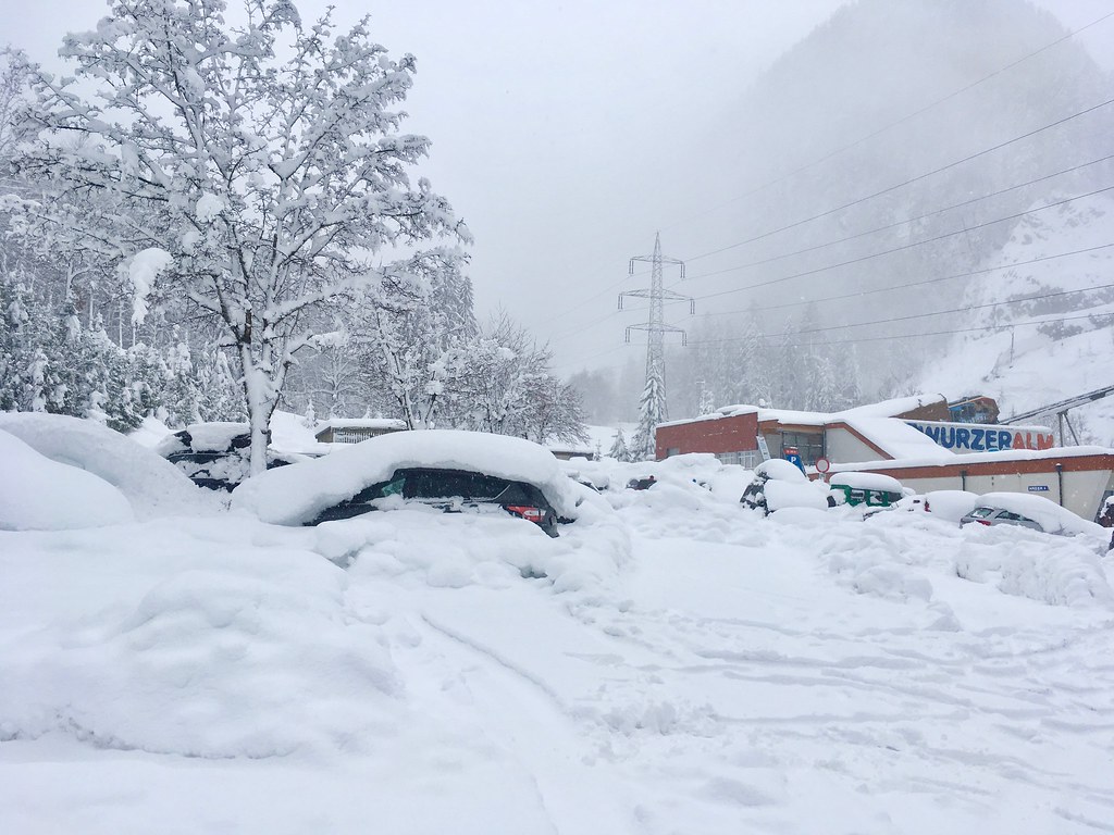
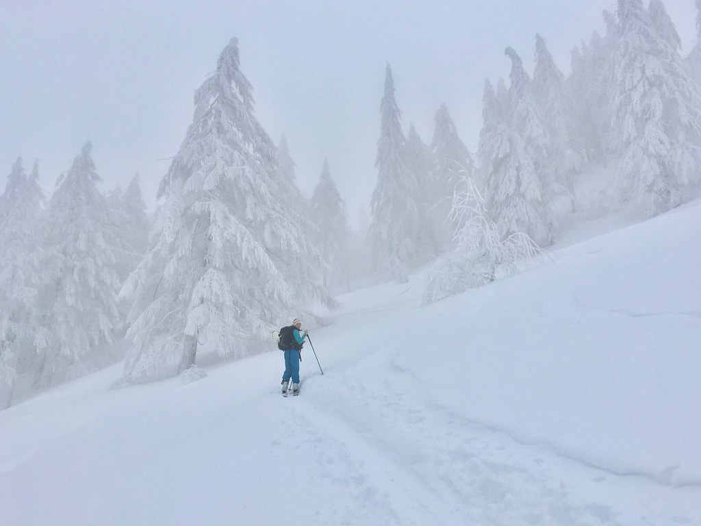
Today was definitely warmer and the snow was getting pretty soggy lower down - but tbh that's not such a bad thing. Will set and bond well when the temps drop in the next few days, covering up any nasty rocks/tree stumps/etc.
Looks like plenty more (and colder!) snow incoming too
Then you can post your own questions or snow reports...
Then you can post your own questions or snow reports...
The latest GFS is printing out 2 - 4 inches liquid over southern Germany and the lowlands of east central Austria over the next 5 days. And a lot of that would be snow. Can anyone remember a significant event like that outside the mountains? Snowfall climatology in the region is difficult to uncover.
I've seen significant blocked flow snow events in valley areas such as Burlington, Vermont and Denver, Colorado, but in the past three years I have rarely witnessed snowfall events >4" in southern Germany below about 600m.
I have seen a few modeled events that didn't materialize and the brunt of the forecasted precipitation is expected in the Friday - Sunday timeframe (which is several days away), so I'm still doubtful of significant snow accumulations outside the mountains and foothills. But there is some support from other models. Either way, it looks incredible for the northern and central ranges of Austria. Colder and drier snow than in recent days too.
After all it is free
After all it is free
Far end of ECM would bring some hope for the West End.
Meanwhile heavy snow, heavy wind and avalanche risk rising to 4 in Salzburgerland.
“Alpine Weather Forecast (ZAMG Salzburg)
Today, Wednesday, visibility is severely impaired by cloud, fog and snowfall. Heavy snowfall is expected to continue, bringing 20-50 cm, most in the region of the Osterhorn range, Northern Alps and western sector of the Hohe Tauern. Markedly less is anticipated in the Nockberge. Stormy NW winds will reach over 100 km/hr. Temperatures will drop: to -12 degrees at 2000m; to -20 degrees at 3000 m.
On Wednesday night, frequent snowfall, but less intense. The NW winds will continue to transport the fresh snow at high altitudes.
Tomorrow, Thursday, mostly good visibility, a bit of sunshine is possible, only brief snow showers. In the afternoon visibility will worsen, snowfall become heavier again. The NW winds will be strong to stormy on the summits, reaching more than 100 km/hr. Temperature at 2000 m: -15 degrees; at 3000 m: -2”
You'll get to see more forums and be part of the best ski club on the net.
You'll get to see more forums and be part of the best ski club on the net.
Is there any hope of snow over the next week in the french alps?
@nozawaonsen, @clarky999, @cad99uk, cheers for the reassurances!
And love to help out and answer questions and of course, read each other's snow reports.
And love to help out and answer questions and of course, read each other's snow reports.
I work about 5km from Salzburg airport, its snowing heavily, it's also pretty windy. The airport is functioning normally, in fact I don't recall it ever being closed due to weather for any significant period.
The roads are fine, mostly white, but nothing abnormal there.
@luigi, don't fret, you're in for some great conditions but wrap up warm.
So if you're just off somewhere snowy come back and post a snow report of your own and we'll all love you very much
So if you're just off somewhere snowy come back and post a snow report of your own and we'll all love you very much
@mk28, in short. No. Sunny though.
You know it makes sense.
You know it makes sense.
queenie pretty please wrote:
I work about 5km from Salzburg airport, its snowing heavily, it's also pretty windy. The airport is functioning normally, in fact I don't recall it ever being closed due to weather for any significant period.
The roads are fine, mostly white, but nothing abnormal there.
@luigi, don't fret, you're in for some great conditions but wrap up warm.
Thanks for that! It looks like the deep cold is only there over the next 3 days, turning back milder and rain at low levels on Sat.
Otherwise you'll just go on seeing the one name:
Otherwise you'll just go on seeing the one name:
For the record a nice ( encouraging) bit of snow across the Berner Oberland this morning. SLF forecast 10 -15cm with 20 - 30cm east of Grimsel pass. Two quick runs on an empty "powder piste" this morning with at least the 10cm beneath the ski!!!
Poster: A snowHead
Poster: A snowHead
There is always hope....remember end of Oct,..similar situation in that France looked blocked, but just a week later the southern alps got 4m and french alps 20-40cm of really powdery snow, enough for a very nice slide on the meadows in oct. This time round the ECM providing short term possibilities...00z on the YR site for PdS
Much less showing on GFS for those dates. But with differences across the models at just 120-144hrs, hard to have confidence further out.
GFS has a known bias to the east...so there is a little hope it corrects more towards ECM.
FV3 06z just out, brings snow to west and south as well from 8th Jan onwards...is that a genoa low appearing?
So a lot of noise even in the short term.....and all the mid term signals still in place as we go further into Jan (SSW, MJO, AAM etc). Effectively a 2 fronted attack on our normal weather patterns, SSW from above, and the other from the tropics. AO has already rolled over, and NAO will follow if GFS moves towards other models. So maybe a brief westerly period will break down the high, and allow ridging further west in the atlantic, with northerlies into central europe.
Obviously A snowHead isn't a real person
Obviously A snowHead isn't a real person
polo wrote:
...is that a genoa low appearing?
You tease, you...
Well, the person's real but it's just a made up name, see?
Well, the person's real but it's just a made up name, see?
I can report lots of snow falling in Seefeld. At least a foot since last night. Not as cold as feared either.
I can report lots of snow falling in Seefeld. At least a foot since last night. Not as cold as feared either.
Thank you for that! I am heading to Seefeld in 10 days so thats great to hear!
Austria as a whole seems to be doing very nicely
Anyway, snowHeads is much more fun if you do.
Anyway, snowHeads is much more fun if you do.
@EarthWindandWater, depends where you are going and what model you look at.....I see you're heading to Flaine, so not ideally placed for a Genoa low being tucked in north of Mont Blanc. But as above, sometimes the northern french alps do benefit from systems hitting the southern alps. In any case, there are signs of the main northerly flow backing far enough west to benefit france. 100% of ECM ensembles predict a N/NW flow 9th onwards, but only 30% show it far enough west.
ECM has had a recent poor run of verification at day 10, so has FV3. But they were top dogs back in Oct-Nov, so odds must be good for them to return to winning ways. One other point is the ECM has better resolution than GFS higher up in the strat, so now that winds have actually reversed, and are in the model starting data, I think ECM is best placed to pick up any SSW impacts filtering down.


 Poster: A snowHead