Poster: A snowHead
|
|
About 30cm of new snow at valley level here. Still snowing heavily.
|
|

|
|
|
|
Obviously A snowHead isn't a real person
Obviously A snowHead isn't a real person
|
| Cheapski wrote: |
Genoa Low is coming !
January 12ish |
Yes please! This could be good for at least parts of France am I right?
|
|
|
|
|
|
Well, the person's real but it's just a made up name, see?
Well, the person's real but it's just a made up name, see?
|
|
@sbooker, I think snow in the Dolomites before 5th Jan looks fairly unlikely based on current forecasts. Unless a dusting creeps over the border from further north.
|
|
|
|
|
|
You need to Login to know who's really who.
You need to Login to know who's really who.
|
|
|
|
Anyway, snowHeads is much more fun if you do.
Anyway, snowHeads is much more fun if you do.
|
|
@JackSkier, in what way is it different? Dry until 7th Jan, then a chance of some precipitation but too far off to be sure. That tallies with what I've been seeing elsewhere.
|
|
|
|
|
|
You'll need to Register first of course.
You'll need to Register first of course.
|
|
|
|
|
|
|
@JackSkier, define what you mean as main forecast sites and different? Also take a look at the scale.
|
|
|
|
|
|
|
|
|
|
|
You'll get to see more forums and be part of the best ski club on the net.
You'll get to see more forums and be part of the best ski club on the net.
|
| nozawaonsen wrote: |
| @JackSkier, define what you mean as main forecast sites and different? Also take a look at the scale. |
Sites like J2ski, Snow-forecast, onthesnow, metcheck, accuweather. The scale on the ensemble?
|
|
|
|
|
|
|
|
|
@JackSkier, you’ll have to try to explain what the difference is you are suggesting exits? As for the scale the chart you have linked to actually has a very small scale. So although those look like quite substantial spikes they need to be set against the scale. If you frame your question better you’ll get a more useful response.
|
|
|
|
|
|
snowHeads are a friendly bunch.
snowHeads are a friendly bunch.
|
|
I think the rain/snow forecast for the Northern Alps coming from the Atlantic keeps getting pushed out a day. This time yesterday GFS had it arriving around lunchtime Monday 7 Jan, today GFS forecasts it will arrive on the 8th. Either way makes for a gloriious day at Tignes - https://tignes.roundshot.com/lac/
|
|
|
|
|
|
And love to help out and answer questions and of course, read each other's snow reports.
And love to help out and answer questions and of course, read each other's snow reports.
|
|
|
|
|
|
@FrediKanoute, the last four GEFS runs have tended to see some ensemble support for more precipitation in the west from around 07/08 January. However, none of them have been particularly compelling at this stage. This shows the last four amalgamated.

Meanwhile out east ECM to next Sunday... (also providing a dusting for the Dolomites).
|
|
|
|
|
|
You know it makes sense.
|
|
Out of interest what's blocking the Austrian snow from making it to the French Alps? Is it high pressure?
|
|
|
|
|
|
Otherwise you'll just go on seeing the one name:
Otherwise you'll just go on seeing the one name:
|
|
@kitenski, yep. Ignatius.
|
|
|
|
|
|
Poster: A snowHead
|
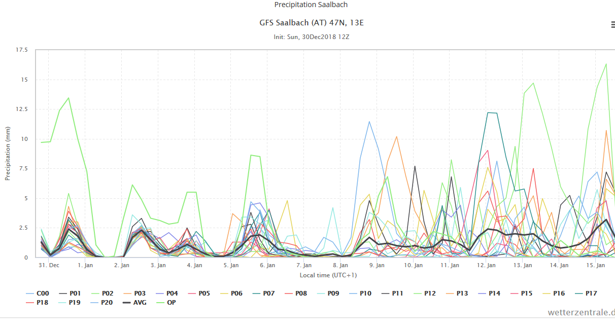
It’s been dumping heavily in Saalbach today, with no sign of easing off. Skiing conditions were already very good (since the previous heavy dump around 10th December), so it should be pretty damn perfect 
|
|
|
|
|
|
Obviously A snowHead isn't a real person
Obviously A snowHead isn't a real person
|
Yep, I think the chance of snowfall out in the Western Alps until around the 9th/10th is fairly poor, the high seems to disintegrate about then.
The Tropospheric Polar Vortex or at least part of it displaces into Siberia over the days leading up to the 10th, and forces a smaller Low into the European Alps, weakening the blocking high.
This is all part of a much more -AAM (Atmospheric Angular Momentum) setup forcing upon Europe a slower jetstream overall, manifesting with the presence of this massive block. And it takes polar forcing to destroy it, which is predicted by GFS around the 10th. EC thinks the 8th/9th. I think it will be nice after the wait, and we should hopefully see a retrograde of the block over the UK to a -NAO (Greenland) position.
|
|
|
|
|
|
Well, the person's real but it's just a made up name, see?
Well, the person's real but it's just a made up name, see?
|
As been previously mentioned earlier on here once in place a high over France is very difficult to displace , sadly I’m of an age to have seen plenty of winters in the alps , it’s not unusual for these highs to last weeks I doubt it’s moving anywhere quick .
When’s the next full moon ? 
|
|
|
|
|
|
You need to Login to know who's really who.
You need to Login to know who's really who.
|
|
@Rob Mackley, well remembered on the full moon
|
|
|
|
|
|
Anyway, snowHeads is much more fun if you do.
Anyway, snowHeads is much more fun if you do.
|
@sbooker, it's looking pretty dry in the Dolomites all next week, as very little of the moisture is making it over the border... see altaski's explanantion of the Froude number.
The forecast dustings should help though.
So enjoy the pow in Austria, the 12z is showing more next week for the Tyrol...then top up your tan in Italy the week after!! 
Though someone earlier mentioned the chance of a Genoa Low for the 12th, it looks like it's an outlier on the charts.
http://old.wetterzentrale.de/pics/MS_1146_ens.png
http://www2.wetter3.de/Animation_12_UTC_05Grad/180_24.gif
|
|
|
|
|
|
You'll need to Register first of course.
You'll need to Register first of course.
|
|
Can anybody give me some info on what's happening near Serre Chevalier? I've got two off piste weeks booked there from the 7th onwards...
|
|
|
|
|
|
|
|
|
|
|
|
|
|
|
|
You'll get to see more forums and be part of the best ski club on the net.
You'll get to see more forums and be part of the best ski club on the net.
|
|
|
|
|
|
|
The anticyclone to the south west of the uk centres right over the uk by Wednesday allowing a strong easterly flow with snow over Austria. Keeps the weather set fair over the UK however.
|
|
|
|
|
|
snowHeads are a friendly bunch.
snowHeads are a friendly bunch.
|
The pattern is really working out for southern Germany, Austria, and all the countries east of there. Stau after stau lining up in the guidance with seasonally cool temperatures. But our worst fears seem to be confirmed for France, western Switzerland, and Italy. First it was rain to high elevation before Christmas, followed by warm temperatures, and now weeks of dry and warm weather with no end in sight. For those of you who enjoy sunny, spring skiing on rocks and grass, congrats. But for the rest of us, this is about as dreadful and ugly as it gets.
If it weren't for man-made snow, dozens of resorts would have to shut down. Elevations above 2000m in a high mountain range at 45°N should have a deep snowcover as we begin January.
|
|
|
|
|
|
And love to help out and answer questions and of course, read each other's snow reports.
And love to help out and answer questions and of course, read each other's snow reports.
|
|
Pretty high freezing level in southern Germany today. Looks to be up over 1200m with local variations. Snow level primarily between 600m and 700m with snow periodically mixing at lower elevations in more intense precipitation. Lots of Atlantic warmth tainting the boundary layer.
|
|
|
|
|
|
|
|
| altaski8 wrote: |
| If it weren't for man-made snow, dozens of resorts would have to shut down. |
That is true, there would be little skiable below 1700/1800 meters.
Doesn't look like significant change in the weather until early February.
|
|
|
|
|
|
You know it makes sense.
|
|
I wish I could find a good reason to disagree with you @davidof, but it's certainly looking that way at the moment and heading for Chatel soon we're going to have to be quite inventive. However looking back over our trips to PDS and before that to the St Gervais/Les Contamines ski areas our best seasons for adventuring have been the slightly dodgy ones. When the snow's good we tend to stay put and ski the stuff in front of us, but when it's not we have to go further afield and have increased our knowledge and range. It's easy to get despondent and with @altaski8, upbeat posts one would think it better to sit inside with a box set, however I for one will be getting out there and making the most of one of the most beautiful mountain ranges in the world with some great culture and opportunity for having fun.
|
|
|
|
|
|
Otherwise you'll just go on seeing the one name:
Otherwise you'll just go on seeing the one name:
|
| altaski8 wrote: |
| Pretty high freezing level in southern Germany today. Looks to be up over 1200m with local variations. Snow level primarily between 600m and 700m with snow periodically mixing at lower elevations in more intense precipitation. Lots of Atlantic warmth tainting the boundary layer. |
AT them elevations, I would view it as a low freezing level. Wouldnt a high freezing level be in the region of 2000m ASL and above?? That just sounds like snow falling to village level in a lot of mountain resorts
|
|
|
|
|
|
Poster: A snowHead
|
| altaski8 wrote: |
| Pretty high freezing level in southern Germany today. Looks to be up over 1200m with local variations. Snow level primarily between 600m and 700m with snow periodically mixing at lower elevations in more intense precipitation. Lots of Atlantic warmth tainting the boundary layer. |
Thankfully, most skiing is over 700m.
Is it looking to get colder by Wed though?
|
|
|
|
|
|
Obviously A snowHead isn't a real person
Obviously A snowHead isn't a real person
|
| altaski8 wrote: |
The pattern is really working out for southern Germany, Austria, and all the countries east of there. Stau after stau lining up in the guidance with seasonally cool temperatures. But our worst fears seem to be confirmed for France, western Switzerland, and Italy. First it was rain to high elevation before Christmas, followed by warm temperatures, and now weeks of dry and warm weather with no end in sight. For those of you who enjoy sunny, spring skiing on rocks and grass, congrats. But for the rest of us, this is about as dreadful and ugly as it gets.
If it weren't for man-made snow, dozens of resorts would have to shut down. Elevations above 2000m in a high mountain range at 45°N should have a deep snowcover as we begin January. |
FOr the Italian Dolomites, I agree its looking mainly dry for the next 10 Days; but I don't agree with it looking warm. After Wednesday the temperature drops and then rises to around average and afterwards looks like dropping to just below average. NOt sure I would classify that as warm.
|
|
|
|
|
|
Well, the person's real but it's just a made up name, see?
Well, the person's real but it's just a made up name, see?
|
| davidof wrote: |
| altaski8 wrote: |
| If it weren't for man-made snow, dozens of resorts would have to shut down. |
That is true, there would be little skiable below 1700/1800 meters.
Doesn't look like significant change in the weather until early February. |
How can you say the weather won’t change until February. That’s a month away! I know these highs can be stubborn but not 6 weeks long surely.
|
|
|
|
|
|
You need to Login to know who's really who.
You need to Login to know who's really who.
|
| alj wrote: |
| I wish I could find a good reason to disagree with you @davidof, but it's certainly looking that way at the moment and heading for Chatel soon we're going to have to be quite inventive. . |
I've skied all over during the Christmas break. I'm taking a few days off from piste skiing because the edges on my skis are blunt but the skiing I've done, especially over 1800 m, has been good, for Xmas.
|
|
|
|
|
|
Anyway, snowHeads is much more fun if you do.
Anyway, snowHeads is much more fun if you do.
|
| Raven wrote: |
| davidof wrote: |
| altaski8 wrote: |
| If it weren't for man-made snow, dozens of resorts would have to shut down. |
That is true, there would be little skiable below 1700/1800 meters.
Doesn't look like significant change in the weather until early February. |
How can you say the weather won’t change until February. That’s a month away! I know these highs can be stubborn but not 6 weeks long surely. |
High pressure can quite easily block moisture into parts of the Alps for 6 weeks or more. Look how long high pressure lasted during summertime in the UK and blocked any rain bearing weather fronts. The thing I've noticed with high pressure is that the areas of high pressure tend to be large and can cover a large area. These areas also tend to meander around, but because they are so vast, they can easily block ATlantic or mediterranean moisture into the Alps. The centre of the high could be positioned anywhere in Western Europe and thus quite easily block any moisture. Luckily for Austria currently, the high is positioned just far enough West to allow weather fronts into the NE Alps during the next week or so
|
|
|
|
|
|
You'll need to Register first of course.
You'll need to Register first of course.
|
| Quote: |
Raven wrote:
davidof wrote:
altaski8 wrote:
If it weren't for man-made snow, dozens of resorts would have to shut down.
That is true, there would be little skiable below 1700/1800 meters.
Doesn't look like significant change in the weather until early February.
How can you say the weather won’t change until February. That’s a month away! I know these highs can be stubborn but not 6 weeks long surely.
High pressure can quite easily block moisture into parts of the Alps for 6 weeks or more. Look how long high pressure lasted during summertime in the UK and blocked any rain bearing weather fronts. The thing I've noticed with high pressure is that the areas of high pressure tend to be large and can cover a large area. These areas also tend to meander around, but because they are so vast, they can easily block ATlantic or mediterranean moisture into the Alps. The centre of the high could be positioned anywhere in Western Europe and thus quite easily block any moisture. Luckily for Austria currently, the high is positioned just far enough West to allow weather fronts into the NE Alps during the next week or so
|
fair point, but due to the massive areas involved is there any particular reason why the high in question couldn't shift to bring the same snowy weather further west? obviously just because it "could" doesn't mean in any way that it would, but is there an atmospheric reason that would prevent this?
|
|
|
|
|
|
|
|
| jimmybog wrote: |
| altaski8 wrote: |
| Pretty high freezing level in southern Germany today. Looks to be up over 1200m with local variations. Snow level primarily between 600m and 700m with snow periodically mixing at lower elevations in more intense precipitation. Lots of Atlantic warmth tainting the boundary layer. |
AT them elevations, I would view it as a low freezing level. Wouldnt a high freezing level be in the region of 2000m ASL and above?? That just sounds like snow falling to village level in a lot of mountain resorts |
It's a high freezing level for that part of Europe at the very end of December, especially with mid-level winds from the NNE and relatively low mid-level geopotential heights. The snow is pretty wet until you get pretty high. And surface temperatures are slowly rising.
|
|
|
|
|
|
|
|
| MountainIdiot wrote: |
| Quote: |
Raven wrote:
davidof wrote:
altaski8 wrote:
If it weren't for man-made snow, dozens of resorts would have to shut down.
That is true, there would be little skiable below 1700/1800 meters.
Doesn't look like significant change in the weather until early February.
How can you say the weather won’t change until February. That’s a month away! I know these highs can be stubborn but not 6 weeks long surely.
High pressure can quite easily block moisture into parts of the Alps for 6 weeks or more. Look how long high pressure lasted during summertime in the UK and blocked any rain bearing weather fronts. The thing I've noticed with high pressure is that the areas of high pressure tend to be large and can cover a large area. These areas also tend to meander around, but because they are so vast, they can easily block ATlantic or mediterranean moisture into the Alps. The centre of the high could be positioned anywhere in Western Europe and thus quite easily block any moisture. Luckily for Austria currently, the high is positioned just far enough West to allow weather fronts into the NE Alps during the next week or so
|
fair point, but due to the massive areas involved is there any particular reason why the high in question couldn't shift to bring the same snowy weather further west? obviously just because it "could" doesn't mean in any way that it would, but is there an atmospheric reason that would prevent this? |
Yes of course it could shift to a more favourable position. It could move South West to allow Atlantic fronts over the top of it into the Western Alps. It could also move North to allow the Atlantic in underneath it. For the past few weeks (as I recall) its been centred over Iberia, Western France and the Uk, thus mainly blocking the moisture into the Southern Alps. What I was trying to get at, is that because the area of pressure can be large, it would have to move quite a distance in a favourable direction to allow moisture into certain parts of the Alps. 6 or more weeks of the high blocking parts of the Alps is certainly very possible.
|
|
|
|
|
|
You'll get to see more forums and be part of the best ski club on the net.
You'll get to see more forums and be part of the best ski club on the net.
|
It's still pantomime season, so let's look at the positives in FI
30hpa and 10hpa heating up fast right now, strat winds stay in reverse for at least a week, these are unusual events and there are tentative signs that the impact will trickle down to our weather. Bottom right corner shows the mean global wind anomaly at 80-90N turning blue - this would mean poleward blocking, -AO, and the first signs of SSW impact. Of course the blocking could be in the wrong place for the alps, but these charts are signalling change is coming.

Even for the next 10 days, temps look below average, with the mean FL staying below 1200m in the NW alps. So plently of cold sunny days, with cannons firing all night and enjoyable piste conditions for those who like that stuff.
Avoriaz area sees some light snowfall 5/6th and heavier on 9/10th if GFS 06z is right.
Looking at the ensembles, main model Op runs are on the mild / dry / boring side of their suites. Some great looking charts in the GFS range for a ridge to build in the atlantic up toward greenland, and corresponding low pressure over UK/europe. Below is the mean chart for 11th Jan

And finally here are the ECM ens for same date.....4 purple boxes (N/NW flow) out of 5, so odds are building for the high pressure slug to get pulled NW and drop europe into more widespread wintriness.

I'll sign off with a shot of my last fresh tracks...sadly 2 weeks ago, but plenty more ahead. For those in Austria next week, be safe, and make the most of it. Here's to a great 2019

Last edited by You'll get to see more forums and be part of the best ski club on the net. on Mon 31-12-18 13:31; edited 1 time in total
|
|
|
|
|
|
|
|
| alj wrote: |
| however I for one will be getting out there and making the most of one of the most beautiful mountain ranges in the world with some great culture and opportunity for having fun. |
When you have to start posting about "culture," you know the conditions are getting bad 
I'll be out there exploring too. Some days in the powder and some days on the scraped-bare pistes.
|
|
|
|
|
|
|
|