 Poster: A snowHead
|
| nozawaonsen wrote: |
| Intense summer storms have continued to wash away roads, dump hail and cause floods through parts of central Austria today....... |
Could well be our turn tomorrow - but what I like about weather in the mountains in the summer is that you tend to have only one day of rain in a week and then things return to normal.
Temps overnight drop to almost single figs and then rise steadily to nigh on 30 around 17:00 which seems to be the hottest time of day with a stiff thermal breeze - hence if out cycling then we get out in the morning, though does depend on what distance you're planning on.
|
|

|
|
|
|
Obviously A snowHead isn't a real person
Obviously A snowHead isn't a real person
|
|
Bit unsettled over the next few days, high winds and at times rain though by the end of the week that looks like 20cm snow down to around 2200m at Hintertux, before warming up again.
|
|
|
|
|
|
Well, the person's real but it's just a made up name, see?
Well, the person's real but it's just a made up name, see?
|
Well yesterday was indeed "intense" !
Thunderstorms pretty well all day from 05:00 through to 20:00 and very heavy rain at times!
Not fun at all if under canvas.
Weather clearing this morning as you can see, though up towards Lautaret / Galibier pretty grim still but forecast is for it to clear hopefully, as OH is running up to Galibier off road with Les Chiens and me on MTB.

|
|
|
|
|
|
You need to Login to know who's really who.
You need to Login to know who's really who.
|
Weathercam, lovely picture.
Pretty grim here in southern England
|
|
|
|
|
|
Anyway, snowHeads is much more fun if you do.
Anyway, snowHeads is much more fun if you do.
|
|
|
|
You'll need to Register first of course.
You'll need to Register first of course.
|
Terrible weather in London today which is why the media has suddenly noticed that it hasn't been a perfect summer.
Ironically the rest of the Uk is enjoying a fine evening tonight 
|
|
|
|
|
|
|
|
|
More stormy weather, lightning and hail pushing through Steirmark and Kärnten.
|
|
|
|
|
|
|
|
Meanwhile ENSO continues to look neutral.
http://www.bom.gov.au/climate/enso/
"The El Niño-Southern Oscillation (ENSO) remains neutral. All climate models surveyed by the Bureau indicate the tropical Pacific Ocean is likely to stay ENSO-neutral for the rest of 2017."
|
|
|
|
|
|
You'll get to see more forums and be part of the best ski club on the net.
You'll get to see more forums and be part of the best ski club on the net.
|
Lots of rain here.
The Ruetzbach (the river that drains/runs down the valley from Stubaier Glacier) just hit its 100 year high water record:
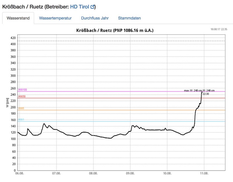
With more rain due over the weekend and next week... Could get messy.
|
|
|
|
|
|
|
|
SLF's Outlook up to yesterday, haven't seen an actual look back yet.
"As a consequence of the high/low, heavy precipitation will be observed from region to region, and temperatures are expected to drop significantly. In western and northern regions, skies are expected to be predominantly overcast on both days. In the Engadine, some final bright intervals will be evident on Thursday, then precipitation will set in, including in eastern and southern regions, which is expected to last until Friday. On Friday afternoon, northerly foehn wind will arise in southern regions and conditions will become dry. The snowfall level will descend swiftly from 3000 m down to approximately 2400 m on Thursday afternoon; then on Friday, down to approximately 2000 m. By Friday evening above approximately 2800 m, the following amounts of fresh fallen snow can be expected:
- Northern Alpine Ridge from the Diablerets to the Reuss as well as in the southern Valais Alps: 30 to 50 cm;
- In the eastern Bernese Oberland and in Goms, as much as 80 cm;
- Remaining regions of Switzerland: 10 to 30 cm.
At 2500 m, about half the above-cited amounts of fresh fallen snow are anticipated; at 2000 m, barely any snow will remain on the ground.
Winds will be blowing at light to moderate strength at 3000 m; at 4000 m, winds will be strong and shift from southerly to northerly.
Temperatures warming up again now.
|
|
|
|
|
|
snowHeads are a friendly bunch.
snowHeads are a friendly bunch.
|
|
Yesterday on a pass at 3003m in Aosta valey (Rhemes Notre Dame) was scared by a heavy snow. So that I thought I would not be able to find a hiking path ... snowed till circa 2600 m. .... few days before that it was 34 degrees in Aosta town and I was going from one to another gelato stand ....
|
|
|
|
|
|
And love to help out and answer questions and of course, read each other's snow reports.
And love to help out and answer questions and of course, read each other's snow reports.
|
|
|
|
|
|
|
So, about la nina. Does it affect europe and the alps as much as it does north america?
|
|
|
|
|
|
You know it makes sense.
|
| staffsan wrote: |
| So, about la nina. Does it affect europe and the alps as much as it does north america? |
Not very much. The teleconnections aren't very good for La Niña. Some authors including scientists at EC, suggest La Niña equals roughly a +NAO, but correlations are a little sketchy. The correlations are much better in the US, but even then it's strictly a guide only. A season will fluctuate and change, according to various factors beyond ENSO. I don't focus on ENSO that much personally, more important drivers IMO.
|
|
|
|
|
|
Otherwise you'll just go on seeing the one name:
Otherwise you'll just go on seeing the one name:
|
@staffsan, try the quote below from last year's thread (quoting from previous threads).
In short though there is no straightforward correlation in the US and even less in Europe.
You could look at things like QBO (easterly phase this winter which could mean -NAO, which tends towards a colder winter in Europe, but often drier in the northern Alps, wetter on the south side). Or look at the solar cycle. Or indeed arctic ice extent and Siberian snow cover in autumn. All these things may give a feel for the overall background conditions. Then again they may not as none of the correlations are strong enough nor the complexity of how they interact well enough understood to allow for confidence in any form of long range forecasts. That doesn't make all attempts at long range forecasting pointless, just that you need to be up front about how much confidence you should have in them.
| nozawaonsen wrote: |
What does that mean? Here's something from the 2013/14 thread...
| nozawaonsen wrote: |
Not a huge amount is the short answer, especially for Europe.
From 2012/13 thread.
"Here's a good article from offpistemag.com by Leigh Jones and Wendy Wagner on the impact or not of ENSO in the US.
Demystifying ENSO
"In the Pacific Northwest, British Columbia, and the Intermountain North, an El Niño winter has a greater chance to be
drier and warmer than average, and vice versa for a La Niña winter. For California and the Southwest, El Niño winters have a greater chance to be wetter than average, and vice versa for La Niña. Furthermore, the stronger the El Niño or La Niña, the greater the chance of seeing an out- of-the-norm winter. But don’t kid yourself – it’s way more complicated than just that.
The dirty little secret that gets drowned out in the hype is that any one climate signal doesn’t necessarily guarantee that your snow season is going to be a boom or a bust. Some regions in the West experience La Niña more strongly than El Niño (the Pacific Northwest and British Columbia). For some regions, the opposite is true. Some regions won’t typically see impacts from El Niño or La Niña when the signal is weak, but only when it is moderate-to-strong (the Sierra Nevada). Some regions may experience large variability within a season, where the early or late season may be more heavily weighted (Colorado). And if you ski Utah’s Wasatch, the surprising truth is that there’s just no reliable correlation between ENSO and the “Greatest Snow on Earth.”
But as they say... it's more complicated than that..." |
|
|
|
|
|
|
|
Poster: A snowHead
|
Some stunning weather in the Tirol and round Salzkammergut in the last few days broke last night with strong storms pushing across with heavy winds and rain. Sadly two people were killed when the storm hit a festival in upper Austria bringing down scaffolding.
In the mountains the snow level will fall below 3000m bringing about 10-15 cm to Hintertux.
|
|
|
|
|
|
Obviously A snowHead isn't a real person
Obviously A snowHead isn't a real person
|
|
|
|
Well, the person's real but it's just a made up name, see?
Well, the person's real but it's just a made up name, see?
|
|
|
|
You need to Login to know who's really who.
You need to Login to know who's really who.
|
Given it's August, no outlook is going to be accurate. Most forecasters start September/October. Also not quite sure you can call that an outlook...
|
|
|
|
|
|
Anyway, snowHeads is much more fun if you do.
Anyway, snowHeads is much more fun if you do.
|
@Jellybeans1000, well obviously it's not an outlook as such, but rather
"serves as a friendly reminder of the limited value of extended outlooks for doing any real planning for your ski season, vacation, or adventures. The skill of such outlooks is generally low..."
whether they are made in August, September or October. Fun maybe, but don't take them that seriously. As Steenburgh dryly observed a little earlier...
"Keep calm, carry on, and ignore any long-term forecasts for this coming winter. Of course, I say that every year."
Or indeed last August and September.
http://wasatchweatherweenies.blogspot.co.at/2016/09/la-nina-watch-cancelled-but-you.html?m=0
http://wasatchweatherweenies.blogspot.co.at/2016/08/silly-season-returns.html
And as Steenburgh suggests Joel Gratz had a great piece on it a while back too.
http://opensnow.com/news/post/long-range-weather-forecasts-stink-a-look-back-at-the-winter-snow-forecast-for-2015-2016
Open Snow
WeatherBell
Accuweather
NOAA
OnTheSnow
Farmers Almanac
Slate
All got their long term winter forecasts wrong.
So fun (especially if they say a lot of snow is coming) interesting (because trying to get a grip on the chaos is fascinating) and sometimes right (though not enough to know when). Which doesn't make them pointless, far from it, but does mean they need to be seen in context and their weakness recognised otherwise it risks misleading people.
|
|
|
|
|
|
You'll need to Register first of course.
You'll need to Register first of course.
|
Many wise words. I'm not going to be fooled by the siberian snow, sunspot minimums, -QBO, -NAO, mini El Nina, 1937 analogs etc. Instead I am spending the time watching the subtle changes in foliage and wildlife, while at the same time buying avalanche safety equipment just in case.
Tomatogedden here at the moment, up to my eyeballs in the stuff. Plenty of sauce going in the freezer for the long cold winter ahead.
|
|
|
|
|
|
|
|
Interesting look at last season in Switzerland from SLF.
http://www.slf.ch/schneeinfo/wochenbericht/2016-17/Jahresbericht/index_FR
A quick summary of a few of the key points:
- Winter looked full of promise following snow falls in mid November, but...
- Following a period of Foehn December was the driest and least snowy since records began.
- Snowfall in January in cold temperatures fell on a weak snowpack leading to a critical avalanche situation which lasted into February.
- In March heavy snow with a shifting snow line lead to a large number of spontaneous avalanches, some very large.
- March was very mild though winter returned in mid April. It was the 6th mildest winter in the Swiss Alps since 1864. Winter arrived late and the spring melt was early [setting aside the late April snow].
- Far lower number of avalanche victims in Switzerland than normal.
|
|
|
|
|
|
|
|
A look back at last season's long term forecasts for the US by Joel Gratz.
https://opensnow.com/news/post/long-range-weather-forecasts-stink-a-look-back-at-the-winter-snow-forecast-for-2016-2017
"Closing thoughts on seasonal outlooks
Some long-range forecasts can provide value, but most will turn out to be incorrect. One day, perhaps in 20-40 years, this won’t be the case. But for now, 3-6+ month forecasts are not something that meteorologists do very well.
It is fun to look at the seasonal forecasts and learn about the logic that is used to create them. But don’t take the forecasts too seriously, and save them so you can look back in 6 months to see if they were accurate:-)"
|
|
|
|
|
|
You'll get to see more forums and be part of the best ski club on the net.
You'll get to see more forums and be part of the best ski club on the net.
|
|
|
|
|
|
@Jellybeans1000, could you explain why those charts suggest a dry season?
The first chart is just temp anomaly so it'll be hotter than average pushing the snow line higher?
The second chart is precipitation anomaly, the green blob covering many of the ski resorts signifies slightly more precipitation than average?
As people have already said seasonal forecasts aren't to be trusted just wondering if i'm missing something basic about the 2nd chart.
|
|
|
|
|
|
snowHeads are a friendly bunch.
snowHeads are a friendly bunch.
|
|
|
|
And love to help out and answer questions and of course, read each other's snow reports.
And love to help out and answer questions and of course, read each other's snow reports.
|
| Daishan wrote: |
@Jellybeans1000, could you explain why those charts suggest a dry season?
The first chart is just temp anomaly so it'll be hotter than average pushing the snow line higher?
The second chart is precipitation anomaly, the green blob covering many of the ski resorts signifies slightly more precipitation than average?
As people have already said seasonal forecasts aren't to be trusted just wondering if i'm missing something basic about the 2nd chart. |
Sorry I meant warm not dry. 
|
|
|
|
|
|
|
|
|
|
|
You know it makes sense.
|
|
|
|
Otherwise you'll just go on seeing the one name:
Otherwise you'll just go on seeing the one name:
|
|
September looks like starting with a brief cooler spell. Snowfall dropping from 3000-2000m next weekend. Maybe 10-20cm at altitude in the east 5-10cm in the west.
|
|
|
|
|
|
Poster: A snowHead
|
|
Cooling down tomorrow. 13c max in the north Pennines.
|
|
|
|
|
|
Obviously A snowHead isn't a real person
Obviously A snowHead isn't a real person
|
Reading about Harvey
"Based on the number of people affected, amount of water involved, and other factors, meteorologists have warned, there may be no parallel available to any other rainstorm in U.S. history as Mashable's Andrew Freeman reports Tropical Storm Harvey has dropped more than 11 trillion gallons of water on Texas."
|
|
|
|
|
|
Well, the person's real but it's just a made up name, see?
Well, the person's real but it's just a made up name, see?
|
More background on Harvey.
Hurricane Harvey: Why Is It So Extreme?
https://www.scientificamerican.com/article/hurricane-harvey-why-is-it-so-extreme/
This part I found fascinating...
"How can Harvey produce such extreme rainfall even though it is no longer over the ocean?
The answer to this is fascinating. Normally a hurricane pulls moisture up from the ocean and releases it as rain all around the storm’s area, particularly in the northeastern quadrant. But Harvey has dropped so much water over such a large area of southeastern Texas that the storm is pulling that water back up into itself and dumping it again as more rain. The flood area is so far and wide that it is acting like part of an ocean, feeding warm moisture up into Harvey. “You only need about 50 percent of the land to be covered with water for that to happen,” Masters says. “Obviously we have more than that in Texas.”"
|
|
|
|
|
|
You need to Login to know who's really who.
You need to Login to know who's really who.
|
|
Well, winter is on its way - first sound of geese this morning as two skeins went over the house.
|
|
|
|
|
|
Anyway, snowHeads is much more fun if you do.
Anyway, snowHeads is much more fun if you do.
|
|
|
|
You'll need to Register first of course.
You'll need to Register first of course.
|
|
First snowfall of autumn... Snow line looks like dropping to 1700m in Hintertux by Saturday with 30-50cm snow for the glacier. Staying chilly till the second half of next week.
|
|
|
|
|
|
|
|
Warm by us today,

but the weekend looks a bit different.
|
|
|
|
|
|
|
|
SLF outlook.
"On Thursday evening east of the Reuss and in southern regions, intensive precipitation is expected in the initial phase, particularly during the night in Grisons. During the daytime on Friday and in the other regions of Switzerland, the precipitation will taper off somewhat. In the furthermost western regions and in the Valais, it will remain dry during the day on Friday by and large. The snowfall level will descend from 3000 m to 2500 m, in the Engadine from 3500 m to 2800 m. The wind will be blowing at light to moderate strength and shift to northwesterly. All in all, the following amounts of fresh fallen snow are anticipated between Thursday afternoon and Friday evening:
- highest summits of the Bernina region: as much as 80 cm above approximately 3500 m;
- central and eastern sectors of the northern flank of the Alps, Gotthard region, northern and central Grisons: 20 to 40 cm above approximately 3200 m;
- remaining regions of the Bernese Oberland and of the Valais: about 10 cm above approximately 3200 m.
At altitudes below the ones cited, the anticipated amounts of fresh fallen snow will be far less.
Outlook
Saturday, 2 September
On Saturday, skies are expected to be heavily overcast and there will be snowfall down to about 2000 m, which is expected to be intensive in the central and eastern sectors of the northern flank of the Alps as well as in northern Grisons. In those regions, in high alpine rigions the danger of dry-snow avalanches will increase significantly; and at intermediate altitudes moist-snowslides over the warm ground are possible.
Sunday, 3 September
On Sunday, skies are expected to be variably cloudy accompanied by sizeable periods of brightness. In northeastern regions more than anywhere else, a small amount of snowfall down to 2000 m is anticipated.
The danger of dry-snow avalanches will decrease incrementally. In the regions registering the greatest amounts of fresh fallen snow, moist-snow sluffs can be expected up into high alpine regions as a result of the solar radiation."
|
|
|
|
|
|
You'll get to see more forums and be part of the best ski club on the net.
You'll get to see more forums and be part of the best ski club on the net.
|
More from SLF.
"Weather review of Friday, 1 September
Skies were heavily overcast and there was precipitation, which in some parts of the southern and eastern regions was heavy. The wind shifted from southerly to northerly and was blowing at light to moderate strength. In northern regions the snowfall level descended from 3000 to 2400 m, in southern regions from 3200 to 2800 m. Between Thursday and Friday afternoon, the following amounts of fresh fallen snow were registered:
- Bernina region: about 60 cm above approximately 3500 m;
- Gotthard region, eastern sector of the northern flank of the Alps, central Grisons: 30 to 60 cm above approximately 3200 m;
- remaining regions of the Bernese Oberland, of the central sector of the northern flank of the Alps and of Goms, northern Grisons: 15 to 30 cm above approximately 3200 m;
- remaining regions of Switzerland: less than 15 cm.
Weather outlook through Sunday, 3 September
On Saturday, skies will be heavily overcast and there will be precipitation. On the northern flank of the Alps and in Grisons, the precipitation is expected to be persistent. On Sunday, the precipitation will diminish, including in the central and eastern sectors of the northern flank of the Alps, and bright intervals are anticipated. In the Valais and in southern regions it will become rather sunny. The northerly wind will be blowing at strong velocity on the Main Alpine Ridge and southwards therefrom, in other regions at moderate strength.
On Friday evening the snowfall level will still be at 2500 m in northern regions and at 3000 m in southern regions. Starting Saturday morning it will descend to approximately 2000 m in all regions. Between Friday afternoon and the end of this round of precipitation on Sunday above approximately 2800 m, the following amounts of fresh fallen snow are anticipated:
- northern flank of the Alps from the Bernese Oberland into the St. Gallen Alps, Grisons: 20 to 50 cm;
- remaining regions of Switzerland: 10 to 20 cm over widespread areas."
Obviously the snow line will quickly retreat as the weather warms, but the first snow of autumn is falling.
|
|
|
|
|
|
|
|
|
It snowed down to 1800 metres here last night. Weather feels quite wintry.
|
|
|
|
|
|
|
|


