 Poster: A snowHead
|
The chart above is based on the 18z and though the snow has pushed back a day or two since yesterday it still looks good for the last week of November arriving 25/26 November primarily to the south and west of the Alps on the basis of that run.
Last edited by Poster: A snowHead on Sun 25-11-12 23:55; edited 13 times in total
|
|

|
|
|
|
Obviously A snowHead isn't a real person
Obviously A snowHead isn't a real person
|
Here's SLF's update:
In southern regions, partially favourable backcountry touring conditions
http://www.slf.ch/lawineninfo/lawinenbulletin/nationale_lawinenbulletins/index_EN
"Most of the snow is to be found along the Main Alpine Ridge from the Simplon region into the Bernina region and southwards thereof. In those regions there is about 50 to 80 cm of snow on the ground at 2500 m. Touring conditions in outlying terrain are favourable in some parts of these regions. In the remaining regions there is about 20 to 50 cm of snow on the ground at 2500 m. The snow line on north facing slopes is at 1500 to 2000 m, on south facing slopes at 1800 to 2600 m, whereby the lower altitude levels generally apply to the southern flank of the Alps."
"On Thursday, 22 November, it will be predominantly overcast. Particularly in western regions, a small amount of precipitation is possible. The snowfall level will be at 1500 m. "
"On Friday, 23 November, a small amount of snowfall is anticipated above approximately 1600 m in southern regions. In northern regions, foehn winds are expected to arise. On Saturday, 24 November, it will be predominantly overcast in all sectors of the Swiss Alps and a bit of snowfall is expected above approximately 1500 m."
|
|
|
|
|
|
Well, the person's real but it's just a made up name, see?
Well, the person's real but it's just a made up name, see?
|
Zermatt looks pretty close to taking a direct hit 25-27 November. Snowfall generally favouring the south and west.

|
|
|
|
|
|
You need to Login to know who's really who.
You need to Login to know who's really who.
|
| nozawaonsen wrote: |
Zermatt looks pretty close to taking a direct hit 25-27 November. Snowfall generally favouring the south and west.
|
Although if the front approaches from the SSW, do you think there will be a Sudstau and the Cervinia side will likely get more?
|
|
|
|
|
|
Anyway, snowHeads is much more fun if you do.
Anyway, snowHeads is much more fun if you do.
|
|
|
|
You'll need to Register first of course.
You'll need to Register first of course.
|
To my eye its looking like a decent chance of snow a week away with temps then dropping below seasonal norm. Still over 7 days away + the rest so all could and probably will change!!
Best pack a few extra layers for 2nd Dec though if that run comes off for Val D'Isere!!
|
|
|
|
|
|
|
|
Ok, getting excited here. Just checked Netweather for Gressoney LT, and looking at the 28th it shows 777mm!!!
Trying to keep my excitement in check......, but as this is precipitation, and I think that is rain, how much snow is this ???
|
|
|
|
|
|
|
|
| bruisedskier wrote: |
| Just checked Netweather... |
Wash your mouth out with soap young man 
|
|
|
|
|
|
You'll get to see more forums and be part of the best ski club on the net.
You'll get to see more forums and be part of the best ski club on the net.
|
| bruisedskier wrote: |
Ok, getting excited here. Just checked Netweather for Gressoney LT, and looking at the 28th it shows 777mm!!!
Trying to keep my excitement in check......, but as this is precipitation, and I think that is rain, how much snow is this ??? |
As a very rough guide 1mm rain = 1cm snow. I'd be surprised if Gressoney got more than 7 metres of snow on the 28th 
|
|
|
|
|
|
|
|
rob@rar, that would be AMAZING... if implausible.
Netweather is bizarrely specific. 7.129mm showing for 2100-2200 on the 26th, and over 50mm total so I don't doubt it says 777mm for the 28th (although I can't see that?).
Precise =/= accurate!
|
|
|
|
|
|
snowHeads are a friendly bunch.
snowHeads are a friendly bunch.
|
|
bobmcstuff, it will just be running off the GFS op run. If you look at the Zermatt/Gressoney 06z ensembles (above) there is clearly an error of some sort. It suggests there will be a lot of snow mind you. Just not that much.
|
|
|
|
|
|
And love to help out and answer questions and of course, read each other's snow reports.
And love to help out and answer questions and of course, read each other's snow reports.
|
|
|
|
|
|
Stevens Pass opened this afternoon. They have received about 30 inches of snow the past 72 hrs. Wed. Mt. Baker and Crystal Mtn open both having received several feet of snow the past 48 hours. Expecting a good bit of snow at about 4,000' FL tonight. Whistler is getting some nice cooler temps and snow too. However, models still not sure about some warming for the weekend, might see snow at the higher elevations around 6,000 feet but maybe mixed rain/snow below that level. Possible that the passes get a bit of cool air coming out of Eastern Washington to keep ski areas cold enough that the precip falls as snow. In any event, I plan to hit the slopes this Saturday though!  We could see several more feet of snow over the next 7 days... We could see several more feet of snow over the next 7 days...
Seattle broke a 60 year reacord for rain fall in a day. Just over 2 inches at Sea-Tac. Lots of flooding in the lowlands and most Western Washington rivers crested their banks last night.
|
|
|
|
|
|
You know it makes sense.
|
| nozawaonsen wrote: |
Zermatt looks pretty close to taking a direct hit 25-27 November. Snowfall generally favouring the south and west.
|
Ramming speed! Snow in the Alps, snow in the Cascades, I could have a really good December. Fingers crossed, along with my toes. T-minus 4 weeks to Zermatt and counting.
|
|
|
|
|
|
Otherwise you'll just go on seeing the one name:
Otherwise you'll just go on seeing the one name:
|
|
^ Zermatt due about ~12 inches of snow next week.
|
|
|
|
|
|
Poster: A snowHead
|
| Whitegold wrote: |
| ^ Zermatt due about ~12 inches of snow next week. |
out of curiosity how have you come to that calculation?
|
|
|
|
|
|
Obviously A snowHead isn't a real person
Obviously A snowHead isn't a real person
|
|
nozawaonsen, you've surely been on here long enough to ignore any of his posts???
|
|
|
|
|
|
Well, the person's real but it's just a made up name, see?
Well, the person's real but it's just a made up name, see?
|
Pretty interesting charts at present. As we go into winter you would normally expect the polar vortex to strengthen, but at present high level blocking is developing and it looks like a split vortex.

This is similar to what happened in late 2010 and whilst there isn't enough cold air about for now to see a repeat at this point you wouldn't rule it out if this sort of pattern was sustained (and we'll have to see whether that comes about).
At the moment it looks like some colder than average weather from this weekend with snow for the Alps, how much is shifting from run to run (the question above was a genuine one), but it looks like a pretty reasonable run into early December is on the cards.
|
|
|
|
|
|
You need to Login to know who's really who.
You need to Login to know who's really who.
|
| nozawaonsen wrote: |
| This is similar to what happened in late 2010 and whilst there isn't enough cold air about for now to see a repeat at this point you wouldn't rule it out if this sort of pattern was sustained (and we'll have to see whether that comes about). |
Eek! I got a touch of frostbite in December 2010, in Meribel. Cold is good, bonkers Arctic temperatures not so much!
|
|
|
|
|
|
Anyway, snowHeads is much more fun if you do.
Anyway, snowHeads is much more fun if you do.
|
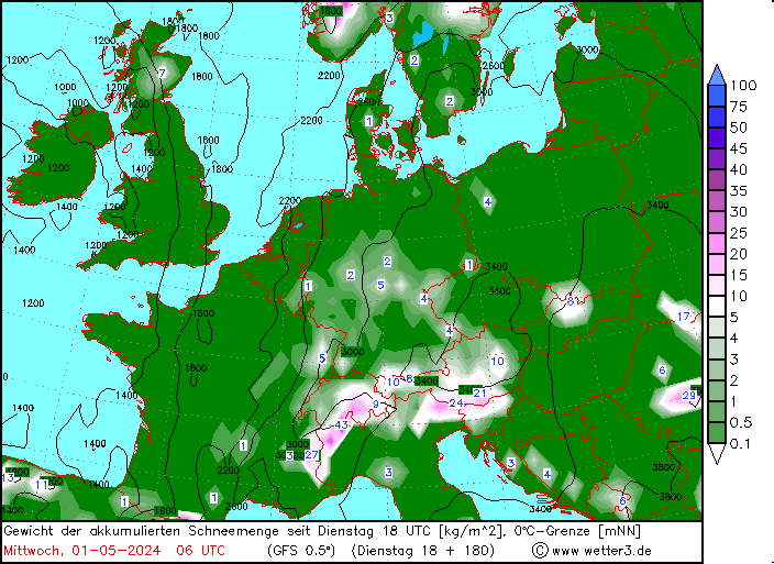
I notice the latest 06z version of the map at the top of this page has shifted the focus of the snow event further East, with heaviest accumulations from SE Switzerland through into Western Austria, anyone know how much snow depth is equivalent to 49kg per m2??
Trying to work it out, 1 litre of water weighs 1kg, so it's 49 litres of water which would spread over a m2 to a depth of 49mm as rain. 1 mm of rain usually means 1cm of snow, so 49cm of snow!
Correct me if I'm wrong, but it appears that the numbers on the chart at the top of the page approximate the depth of Snow Accumulation in cm, though I suppose some compression of the layers would occur in a heavy snowfall and snow is never distributed evenly across mountainous terrain, with some aspects and altitudes receiving different amounts.
|
|
|
|
|
|
You'll need to Register first of course.
You'll need to Register first of course.
|
|
Update...the 12z is now giving 109 kg/m2 for the Silvretta-Ischgl/Samnaun area...so potentially over a metre of snow? Yes, it's only a computer model and a long way off and subject to change, but a number of lucky resorts look like they'll have a good start to the season.
|
|
|
|
|
|
|
|
luigi, it's actually the line above you want to read to see which run it is, that's now this morning's 00z. The red line is when it runs out till (next Wednesday 12z).
You're right that a very rough calculation would allow you to convert those figures to cm of snow. But it is very rough. Complicated by the fact that both exactly predicting snowfall and exactly measuring it once it has fallen is made complex by numerous factors (including temperature' wind and terrain).
Either way though those figures suggest a good start to the season could be on the cards. There has been a tendency for the snowfall to shift back a day or two (not uncommon), but it is drawing closer now with mid week next week looking good.
Last edited by Then you can post your own questions or snow reports... on Wed 21-11-12 10:31; edited 1 time in total
|
|
|
|
|
|
|
|
|
This is getting very exciting......I shall be delighted to be wrong about my pessimistic fantasy snowfall bid. Thanks again, nozawaonsen.
|
|
|
|
|
|
You'll get to see more forums and be part of the best ski club on the net.
You'll get to see more forums and be part of the best ski club on the net.
|
big mounds of man made snow on the valdisere webcams today ( nursery slopes) so they must be confident of it hanging around , appreciate they open soon but its a brave move.
i,m off to La Tania again this year ( 5th jan) so plenty of time for white stuff to fall,but its always nice to have a early fall, anyway champers in the fridge ready for next weeks fall (hopefully) the traditional goddard drink to celebrate the first snowfall that i think will hang around.
noza, good to see you still hanging around despite the abuse you get from some people on here (me) well that was last year,ive changed !!
|
|
|
|
|
|
|
|
|
Hmm, 6z looking good for Tignes and remaining cold afterwards, fingers crossed it comes off!!
|
|
|
|
|
|
snowHeads are a friendly bunch.
snowHeads are a friendly bunch.
|
nozawaonsen,
Is it really coming this time? Snow mainly expected from Sunday? Fairly general but mostly in S + W Alps?
Could do with some good news. My rowing club runs 3 rowing events a year and I have just had to cancel the last one due Saturday. We have lost all 3 this year due to flooding.
Perhaps I will start packing my ski gear Saturday now I have nothing to do. Due out in Espace Killy on 14th Dec and it will be nice to be reasured that there will be much to do.
A fed up Snow and rowing head!
|
|
|
|
|
|
And love to help out and answer questions and of course, read each other's snow reports.
And love to help out and answer questions and of course, read each other's snow reports.
|
| nozawaonsen wrote: |
This is similar to what happened in late 2010 and whilst there isn't enough cold air about for now to see a repeat at this point you wouldn't rule it out if this sort of pattern was sustained (and we'll have to see whether that comes about).
At the moment it looks like some colder than average weather from this weekend with snow for the Alps, how much is shifting from run to run (the question above was a genuine one), but it looks like a pretty reasonable run into early December is on the cards. |
Can someone please enlighten me to what happened in late 2010?
Thanks.
|
|
|
|
|
|
|
|
|
We had northern blocking in late november 2010...in the south east of the uk on the 29th there was significant snowfall......as there was in the alps....my first trip that season to austria was on the 14th december and at 700m the resort was deep in snow and temps in the day were minus 20 degrees. It lasted for a reasonable period.....rare for the uk
|
|
|
|
|
|
You know it makes sense.
|
| seany1 wrote: |
| We had northern blocking in late november 2010...in the south east of the uk on the 29th there was significant snowfall......as there was in the alps....my first trip that season to austria was on the 14th december and at 700m the resort was deep in snow and temps in the day were minus 20 degrees. It lasted for a reasonable period.....rare for the uk |
Thanks. So potentially this could be a good thing if the blocking allows, cool moist air to be forced over the Alps, where the clouds have no choice due to the laws of mother nature, but to dispense copious quantities of cold smoke powder!
|
|
|
|
|
|
Otherwise you'll just go on seeing the one name:
Otherwise you'll just go on seeing the one name:
|
Yes, but what followed was drought for the next few months resulting in one of the worst seasons for years 
|
|
|
|
|
|
Poster: A snowHead
|
Toadman, December 2010 was the coldest in France for 40 years and the coldest in the UK in 100 years. Cold air poured down from the Arctic as a high pressure block over Greenland cut off the moist and milder air from the Atlantic. So it's not as straightforward to just get the cold, we want the moist air too. In general northern blocking leads to a -NAO index which tends to mean wet weather is pushed south so can favour the southern Alps.
There are some strong suggestions of northern blocking in the charts at present which could deliver some very cold weather. Here's the ECM chart for 01 December.

But it's still some way out so I wouldn't count on it and I certainly wouldn't be worried about a snow drought at this point.
|
|
|
|
|
|
Obviously A snowHead isn't a real person
Obviously A snowHead isn't a real person
|
| nozawaonsen wrote: |
| December 2010 was the coldest in France for 40 years |
It was brutal. -25 at village level in Meribel, colder up top for a few days in the middle of December. Fortunately no wind, otherwise the temperature would have been scary. The snow that fell was pretty nice though 
Transport chaos in the UK, IIRC, so not all good news.
|
|
|
|
|
|
Well, the person's real but it's just a made up name, see?
Well, the person's real but it's just a made up name, see?
|
|
|
|
You need to Login to know who's really who.
You need to Login to know who's really who.
|
|
Looks like the forecast has more snow further eastwards now, which is a good thing. Will this system be coming up from the south?
|
|
|
|
|
|
Anyway, snowHeads is much more fun if you do.
Anyway, snowHeads is much more fun if you do.
|
|
Thanks for the history lesson. I guess we will just have to wait and see what transpires over the next few weeks.
|
|
|
|
|
|
You'll need to Register first of course.
You'll need to Register first of course.
|
|
|
|
|
|
Mark1863, wrote
| Quote: |
Could do with some good news. My rowing club runs 3 rowing events a year and I have just had to cancel the last one due Saturday. We have lost all 3 this year due to flooding.
|
and it feels like I've entered most of them. It's been a rubbish year for rowing (apart from the Olympics of course) but that's enough thread drift.
I generally console myself with the fact that rain in UK, MAY mean snow in the mountains, but this thread is a lot more scientific..
|
|
|
|
|
|
|
|
|
Bit of a shift back west this morning. But the overall pattern looks good with snow arriving from next Monday/Tuesday through Wednesday followed by colder weather.
|
|
|
|
|
|
You'll get to see more forums and be part of the best ski club on the net.
You'll get to see more forums and be part of the best ski club on the net.
|
Fingers crossed for a decent amount 
|
|
|
|
|
|
|
|
| Quote: |
Looks like the forecast has more snow further eastwards now, which is a good thing. Will this system be coming up from the south?
|
No, it's coming from the North/NorthEast. Similar set up to November 2010 - best Scottish season since 1962/3 because it just kept snowing here. Not good for the Dolomites IIRC. No reason that the Alps would end up in another drought but hey if it all happens again, maybe some of you should look northwards for better conditions. 
|
|
|
|
|
|
|
|


