Poster: A snowHead
|
@staffsan, it means different things for different parts of the Alps.
A +NAO/AO is associated with a stronger Atlantic flow. This tends to bring more snowfall to the northern Alps, but can be milder.
A -NAO/AO is associated with a blocked pattern which allows cold air to flow across Europe, but also forces the jet further south therefore favouring the southern Alps for snowfall (and possibly leaving the northern Alpd dry).
|
|

|
|
|
|
Obviously A snowHead isn't a real person
Obviously A snowHead isn't a real person
|
|
Are further falls in the Alps this coming weekend completely off the cards now?
|
|
|
|
|
|
Well, the person's real but it's just a made up name, see?
Well, the person's real but it's just a made up name, see?
|
|
No I think it will snow. Though not currently suggesting anything like recent falls.
|
|
|
|
|
|
You need to Login to know who's really who.
You need to Login to know who's really who.
|
My more primitive weather forecast source (yr) forecasts some snow this weekend and significant snowfall around wednesday next week (22nd) for the Zillertal at least. Does ECM and GFS agree?  (does yr use ECM or have i gotten that wrong?) (does yr use ECM or have i gotten that wrong?)
|
|
|
|
|
|
Anyway, snowHeads is much more fun if you do.
Anyway, snowHeads is much more fun if you do.
|
|
@staffsan, yr.no uses ECM data. So not surprisingly you can see that in the ECM data around 22/23. However, that’s too far out to take seriously at this stage. Again not surprisingly GFS looks very different at that range. Still it’s a nice option.
|
|
|
|
|
|
You'll need to Register first of course.
You'll need to Register first of course.
|
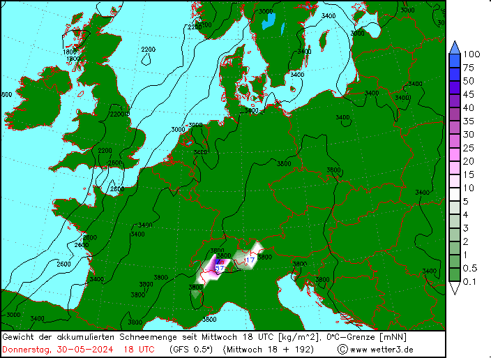
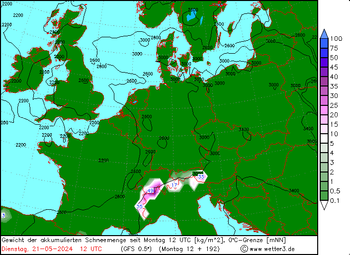
A rough idea of where snowfall is likely over the next week according to the 18z GFS run.
|
|
|
|
|
|
|
|
And this is how ZAMG currently sees snowfall this weekend.

So in the 5-15cms range for many places.
|
|
|
|
|
|
|
|
Here‘s SLF‘s wrap on the recent snowfall.
“Since the lastest round of snowfall commenced on Saturday afternoon, the following overall amounts of snowfall have been registered above approximately 2200 m:
- northern flank of the Alps, northern part of Lower Valais: 50 to 80 cm, from place to place as much as 100 cm;
- remaining regions north of an imaginary Rhine-Rhone line, southern part of Lower Valais, northern Grisons: 30 to 50 cm;
- southern part of Upper Valais, northern Ticino, remaining parts of central Grisons, northern part of Upper Engadine, Lower Engadine: 15 to 30 cm;
- remaining regions of Switzerland, less.“
And whilst you are now doubtless considering whether it would be viable to mark out that imaginary Rhine-Rhone line, perhaps with something like a Graco LineLazer V 3900 Standard Airless Line Striper, maybe in bright pink, pause to think about Geese. Because it‘s that time of year or was on Saturday, but restaurants are still serving. Yum.
„Sankt Martin weiß, Winter lang und kalt.“
|
|
|
|
|
|
You'll get to see more forums and be part of the best ski club on the net.
You'll get to see more forums and be part of the best ski club on the net.
|
GFS and ECM currently have a milder spell from 22-24 November. GFS then continues this for several more days.
But that is far enough out that I wouldn’t take it that seriously, the GFS op was an outlier and it is one of several options that has been conjured up recently.
Nevertheless whilst a mild spell is not that well supported right now nor at this stage is there is a clear signal for an extended cold spell continuing to the end of the month.

|
|
|
|
|
|
|
|
GFS 12z op run sees most of the snowfall this weekend and Monday falling in Austria.
|
|
|
|
|
|
snowHeads are a friendly bunch.
snowHeads are a friendly bunch.
|
|
After a cold spell this weekend 12z GFS and 12z ECM both show high pressure and milder temperatures across the Alps for at least a few days from 22 November.
|
|
|
|
|
|
And love to help out and answer questions and of course, read each other's snow reports.
And love to help out and answer questions and of course, read each other's snow reports.
|
|
18z GFS continues the trend of a mild and dry FI. At least a spell of these conditions now look likely from middle of next week. Whether it extends we’ll have to wait and see. In the meantime quite a bit of snow heading towards Austria this weekend.
|
|
|
|
|
|
|
|
|
|
|
You know it makes sense.
|
GFS 12Z looks snowier for the weekend...more in line with ECMWF/ZAMG 
Also colder going in to next week.
|
|
|
|
|
|
Otherwise you'll just go on seeing the one name:
Otherwise you'll just go on seeing the one name:
|
|
12z and 18z GFS more in line with earlier ECM with cold and snow sweeping down from around 25 November. Of course ECM 12z backed off slightly. So will be interesting to see which way it goes tomorrow...
|
|
|
|
|
|
Poster: A snowHead
|
|
We currently have high latitude blocking, creating a weak tropospheric vortex. For those not clued in, we have a -AO coming in, that is expected to be a quite strong phase. This means colder air will be coming down to the mid latitudes and Europe, giving colder air and more snow options to the continent.
|
|
|
|
|
|
Obviously A snowHead isn't a real person
Obviously A snowHead isn't a real person
|
@nozawaonsen,
Great news have an Avi course booked at Dachstein first week Dec. Was worried that they might not have enough snow but they already have 230 cm with another 70 cm to come over the weekend.
|
|
|
|
|
|
Well, the person's real but it's just a made up name, see?
Well, the person's real but it's just a made up name, see?
|
@DB, sounds interesting course is it an ÖAV one?
This morning’s GFS is good with cold weather and relatively heavy snowfall Sunda/Monday for the northern side of the Austrian Alps in particular. 30-60cms at altitude for many places with a snow line down to below 100m. Further west 10-20cms with a snow line between 1000-1500m. Southern side of the Alps much less snowfall if any. Winds look strong in the northern Alps.

Any mild weather currently looks restricted to mid week before colder weather arrives again the following weekend with further snowfall. That said the GFS op run is a bit of an outlier (as you can see in the black ensemble charts above) so will be interesting to see how that develops over day and how ECM plays.
|
|
|
|
|
|
You need to Login to know who's really who.
You need to Login to know who's really who.
|
|
ECM 00z a lot more cautious than GFS. Keeps high pressure and mild temperatures into weekend of 25/26 November. Hints at a shift beyond that, but we are well into FI by that time.
|
|
|
|
|
|
Anyway, snowHeads is much more fun if you do.
Anyway, snowHeads is much more fun if you do.
|
| nozawaonsen wrote: |
@DB, sounds interesting course is it an ÖAV one?
|
It's with Naturfreunde, here's the link
http://team.naturfreunde.at/events/angebot/praxistage-lawinensymposium-nichtmitglieder/
Many experienced people are running the course
• Bernd Zenke - Ehemaliger Leiter LWD Bayern / Former head of Bayern avalanche warning service
• Bernd Heschl - Alpinmediziner und Bergrettungsarzt / Doctor, Mountain rescue
• Christoph Mitterer- LWD Tirol, Österreich / avalanche service Tirol
• Klaus Paffeneder - Leiter der Alpinpolizei Steiermark / Head of Mountain Police Steiermark
• Arno Studeregger - LWD Steiermark, 7 avalanche warning service Steiermark
• Frans van der Kallen - Psychologe, Österreich / psychologist
• Martin Edlinger - Naturfreunde Österreich (LVS-Experte) / Transceiver Expert
• Renate Renner – Uni Graz / University Graz
• Gregor Krenn - Bergführer / Mountain Guide
|
|
|
|
|
|
You'll need to Register first of course.
You'll need to Register first of course.
|
|
What is “FI”?
|
|
|
|
|
|
|
|
|
Fantasy Island, i.e. too far out to take seriously.
|
|
|
|
|
|
|
|
|
Oh, haha!
|
|
|
|
|
|
You'll get to see more forums and be part of the best ski club on the net.
You'll get to see more forums and be part of the best ski club on the net.
|
|
GFS and ECM swerving back towards a milder end to the month.
|
|
|
|
|
|
|
|
|
@nozawaonsen, snow disappearing milder or not???
|
|
|
|
|
|
snowHeads are a friendly bunch.
snowHeads are a friendly bunch.
|
|
Heavy snowfall for Austria (less or nine elsewhere) Sunday to Tuesday down to low levels, but then warming up with high pressure and milder temperatures as we head towards end of November (which will melt lower lying snow).
|
|
|
|
|
|
And love to help out and answer questions and of course, read each other's snow reports.
And love to help out and answer questions and of course, read each other's snow reports.
|
Worth repeating the opening post of this thread?
'To have any confidence in a trend you would want to see it picked up run after run, and also joined by other models'.
'Beyond 7 days you have a range of possibilities....you can't really make sense of these as a single snapshot'.
My only comment here is that I would change the 7 to a 5, otherwise you end up with a load of 'ripe old nonsense'.
One other point / rant - the current dry and warm forecast also shows how -NAO can be useless if the blocks and troughs don't align favorably for the alps. I think too many people bring up the NAO as a major factor on our weather. It does 'phase' for several months one way or the other, but it also has very choppy phases too. Even with a strong signal, like the -ve plunge next week, the associated cold polar air doesn't reach very far south due to euro HP block.
Positive takeaway, it could look very different in 5 days time
|
|
|
|
|
|
|
|
| langball wrote: |
Worth repeating the opening post of this thread?
'To have any confidence in a trend you would want to see it picked up run after run, and also joined by other models'.
'Beyond 7 days you have a range of possibilities....you can't really make sense of these as a single snapshot'.
My only comment here is that I would change the 7 to a 5, otherwise you end up with a load of 'ripe old nonsense'.
One other point / rant - the current dry and warm forecast also shows how -NAO can be useless if the blocks and troughs don't align favorably for the alps. I think too many people bring up the NAO as a major factor on our weather. It does 'phase' for several months one way or the other, but it also has very choppy phases too. Even with a strong signal, like the -ve plunge next week, the associated cold polar air doesn't reach very far south due to euro HP block.
Positive takeaway, it could look very different in 5 days time |
I would respectively disagree with the first comment. 7 days is fine, and if you know what you are doing, you can find meaningful trends beyond that.
The NAO isn't really end all. I put more interest in the AO personally, as the other climate drivers, like ENSO, QBO, Siberia Snow, Arctic Ice, etc, weigh into it more than the NAO. Anyway the NAO is creating a very strong Atlantic on later GFS.
Last edited by So if you're just off somewhere snowy come back and post a snow report of your own and we'll all love you very much  on Sat 18-11-17 0:54; edited 1 time in total on Sat 18-11-17 0:54; edited 1 time in total
|
|
|
|
|
|
You know it makes sense.
|
@langball, whether the NAO (or AO) is positive or negative will give you a broad idea of likely weather patterns over a large area over a period of time (+NAO is associated with strong Atlantic, -NAO is associated with blocking), but like you say that’s only a very broad idea and is pretty limited. Over interpreting it can be unhelpful. And as far as the Alps goes it can have very different implications whether you are to the north or south.
Back to next week 06z GFS continues to see a mild and dry spell from Tuesday which continues by and large till the end of the month. It breaks down in far FI as we go into December on this run.
The potential for a spell of dry and mild weather has been cropping up for a while now. There have been a few colder alternatives thrown in by some op runs but the ensembles do seem to be trending towards dry and mild for now.
Shorter term it’s blinking cold. Snowing this weekend in Austria. And I‘m loading up the car.
|
|
|
|
|
|
Otherwise you'll just go on seeing the one name:
Otherwise you'll just go on seeing the one name:
|
|
|
|
Poster: A snowHead
|
|
|
|
Obviously A snowHead isn't a real person
Obviously A snowHead isn't a real person
|
|
|
|
Well, the person's real but it's just a made up name, see?
Well, the person's real but it's just a made up name, see?
|
@hd, should be some snow reaching back into Switzerland. Heavier in Austria.

|
|
|
|
|
|
You need to Login to know who's really who.
You need to Login to know who's really who.
|
|
@nozawaonsen, great news thanks. Shaping up nicely then for weekend 25-26th as long as the incoming mild weather doesn't do too much damage to the predominantly north facing slopes where I'm heading.
|
|
|
|
|
|
Anyway, snowHeads is much more fun if you do.
Anyway, snowHeads is much more fun if you do.
|
| Quote: |
incoming mild weather doesn't do too much damage to the predominantly north facing slopes where I'm heading
|
I'm concerned about the affects of any rain in Austria. Glaciers/up high should be good whatever though!
On a different note, the Op run from Wetterzentrale seems to be a bit of an outlier for the next few days (less precip, higher temps than the other "squigglies"). Does that show a low sign of confidence? Seems strange that the other squigglies are all more broadly in agreement with each other up to the 22/23 NOv.
http://www.wetterzentrale.de/en/show_diagrams.php?geoid=2990&model=gfs&var=201&run=12&lid=ENS&bw=
|
|
|
|
|
|
You'll need to Register first of course.
You'll need to Register first of course.
|
| leggyblonde wrote: |
| ... squigglies ... |
Even with the username of leggyblonde, you'll not get away with that on here.
The mot juste is "Ensembles" my dear, Ensembles 
|
|
|
|
|
|
|
|
|
|
|
|
|
|
12z GFS continues to have warmer dry weather next week, but by the following week replaces that with cold and fresh snow.
|
|
|
|
|
|
You'll get to see more forums and be part of the best ski club on the net.
You'll get to see more forums and be part of the best ski club on the net.
|
Whether it melts or whether it snows
The squigglies keep us all on our toes
|
|
|
|
|
|
|
|
|
@pam w, you’re a poet and you didn’t know it
|
|
|
|
|
|
|
|