Bit of cloud today and snow for some particularly in the Pyrenees before another spell of mild and sunny weather.
Then all change for the start of February with much colder temperatures and potentially substantial snow fall.
Well, the person's real but it's just a made up name, see?
Well, the person's real but it's just a made up name, see?
yes, large amounts of snow with a lower freezing level feeding through on the charts I can make sense of like Bergfex (50cm/snow a day 1st Feb onwards at Wengen - may even be some snow down to Lauterbrunnen - be nice if everything was nice and white for my visit at half term).
Bit of cloud today and snow for some particularly in the Pyrenees before another spell of mild and sunny weather.
Then all change for the start of February with much colder temperatures and potentially substantial snow fall.
Noza - I'm sure you've answered this question before, where do you get all these lovely pics from? Thanks.
Then you can post your own questions or snow reports...
Then you can post your own questions or snow reports...
@nozawaonsen, It also occurs to me on all the lovely pictures you post that people didn’t wear much warm clothing for skiing in days gone past, is this because we were all made of tougher stuff in the past or that in fact wasn’t as cold in the past as we all like to think it was?
After all it is free
After all it is free
Hi folks. Can anyone give me a simple explanation as to why there is so much snow this early in the season? Thanks!
You'll get to see more forums and be part of the best ski club on the net.
You'll get to see more forums and be part of the best ski club on the net.
@Poogle, it’s snowed a lot.
Ski the Net with snowHeads
Ski the Net with snowHeads
@kitenski
snowHeads are a friendly bunch.
snowHeads are a friendly bunch.
@kitenski,
And love to help out and answer questions and of course, read each other's snow reports.
And love to help out and answer questions and of course, read each other's snow reports.
Could use some snow in the USA. Unfortunately the meter + that has fallen this week from Whistler BC, down to the Tahoe resorts, and continues to fall through Saturday will have a bit of a warm up come Sunday. Guess, get after it while you can!
So if you're just off somewhere snowy come back and post a snow report of your own and we'll all love you very much
So if you're just off somewhere snowy come back and post a snow report of your own and we'll all love you very much
Hey I like it sunny at the start of the week so everyone can see my sweet moves on the sun deck, then I like it colder and snowy at the end of the week so I can snow plough in powder in my aviators!
Then this is the week for you!
Starting sunny then cold and snow by Thursday in the northern Alps.
You know it makes sense.
You know it makes sense.
GFS and ECM both seem to be going for a longish (5 days plus) cold snowy spell from the 1st.
Otherwise you'll just go on seeing the one name:
Otherwise you'll just go on seeing the one name:
snowheads68 wrote:
GFS and ECM both seem to be going for a longish (5 days plus) cold snowy spell from the 1st.
Does that include St. Anton?
Poster: A snowHead
Poster: A snowHead
Looks like sun in Zermatt from 3rd, if a bit chilly. Perfect
Obviously A snowHead isn't a real person
Obviously A snowHead isn't a real person
This gives you an idea of snowfall to low levels from start of February out till 04 February.
Gorgeous weather in Saalbach today, pistes in very five condition. Off piste crusty, though much lighter in shaded north facing areas (also where you will find higher avalanche risk). Time to see if I can find somewhere which sells beer...
Well, the person's real but it's just a made up name, see?
Well, the person's real but it's just a made up name, see?
nozawaonsen wrote:
Bit of cloud today and snow for some particularly in the Pyrenees before another spell of mild and sunny weather.
Then all change for the start of February with much colder temperatures and potentially substantial snow fall.
Just arrived home (Pyrenees) where we have had 50cm fall over the last couple of days with snow down to 600m. Cloudy this morning but clearing a little this afternoon, and the outlook for tomorrow and the first half of the week is a little mild and sunny. Perfect conditions for the up and coming mad holiday rush
@zzz I totally agree, I like weather threads to focus on the outlook, not todays headcam moment, so I read and learn a lot these days on other sites, eg netweather threads that are dedicated to model output and remove non relevant content.
But each to their own.
Anyway, the pro's are very excited about mid Feb (MJO phase 7/8 combined with GWO, AAM signals), don't ask me. Hopefully we get a decent bonus dump next week, though still a lot of disagreement, and looks marginal for west, better odds east I think.
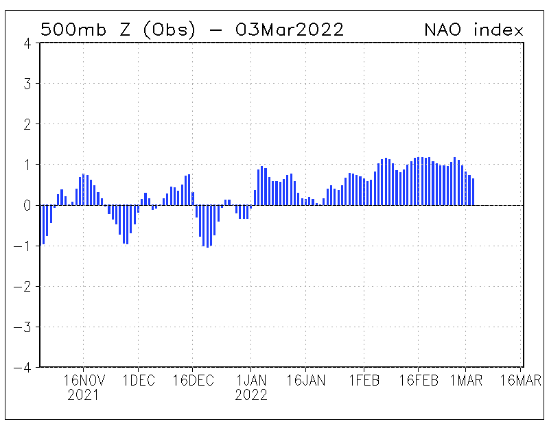
Interesting that NAO has been positive every day since late Nov, during a La Nina winter. But there are many drivers....eg eQBO signal this year is correlated with -NAO, but they reckon warm SSTs off eastern US seaboard have fired up the jet enough to overpower it. So with the seemingly permanent vortex lobe over Canada, we get a steady stream of energy crossing the atlantic with very little MLB (mid lattitude blocking over Greenland or Scandinavia would allow colder air in from the east, albeit drier).
Can't complain either way.....despite a few days of rain lower down, it's been a great season across all of the alps even to low levels....and plenty more in the short and mid term outlooks.
Then you can post your own questions or snow reports...
Then you can post your own questions or snow reports...
langball wrote:
@zzz I totally agree, I like weather threads to focus on the outlook, not todays headcam moment, so I read and learn a lot these days on other sites, eg netweather threads that are dedicated to model output and remove non relevant content.
But each to their own.
langball wrote:
@snoozeboy yes indeed, even travelling in slow motion there were splashes of powder reaching the midriff. I was gonna ask to see your thigh deep videos but nevermind.
After all it is free
After all it is free
langball wrote:
@zzz I totally agree, I like weather threads to focus on the outlook, not todays headcam moment, so I read and learn a lot these days on other sites, eg netweather threads that are dedicated to model output and remove non relevant content.
But each to their own.
Serious question: do you not think it's important/worthwhile to verify how the outlook and forecasts translate into conditions on the ground?
I genuinely find photos/videos of what conditions are actually like in different places very useful when deciding where to ski next. Much easier to accurately judge or convey snow quality, wind influence, depth of base/sharkiness, etc than from written reports which are inherently coloured by the author's opinions and past experience.
I'd also like to point out that if it was about showing off 'headcam moments' I'd be looking for something more interesting than the flattest terrain and shallowest powder that was available at the time...
You'll get to see more forums and be part of the best ski club on the net.
You'll get to see more forums and be part of the best ski club on the net.
Pros excited about mid Feb? Hope that doesn’t mean loads of snowfall. Want sun...
Ski the Net with snowHeads
Ski the Net with snowHeads
buchanan101 wrote:
Pros excited about mid Feb? Hope that doesn’t mean loads of snowfall. Want sun...
Want constant cold, sun in the morning and snow at night
snowHeads are a friendly bunch.
snowHeads are a friendly bunch.
GFS has below average temperatures out till 10 February. ECM less convinced, but a change in the current mild weather is coming from the start of the month.
And love to help out and answer questions and of course, read each other's snow reports.
And love to help out and answer questions and of course, read each other's snow reports.
Uk cools down next week with some snow around over the tops. Should also mean a bit drier, brighter and less depressing weather.
So if you're just off somewhere snowy come back and post a snow report of your own and we'll all love you very much
So if you're just off somewhere snowy come back and post a snow report of your own and we'll all love you very much
Didn't realise I would be seeing 2Pac on a weather forum
EC shows 60-80cm+ in the higher areas of the Alps for the Thu-Fri-Sat system , favouring the Northern Alps. EC shows the next system (next Sun-Mon-Tues) to largely favour Austria, especially on the Tuesday, but the other Northern Alps regions get decent snow too.
@buchanan101, yeah that means more snowfall for the Alps, more activity in general.
@südtirolistdeutsch, the one place where that could happen would be Japan(and maybe the NE resorts), because of it's unique geography.
@langball, I guess some see these threads as observation and forecast threads, which is nice for me, because I like to see the snow in our endless summer over here. But I totally agree that netweather provides a better outlook, which I should add that I am an active poster there.
But Noza provides a good summary of the outlook, with a slice of old photos and 2Pac (apparently). I totally agree with the assessment of the AAM and GWO, I do know Tamara and others in that school. Interesting to see such a consistently +NAO, but I have heard of the warm North West Atlantic SST theories.
You know it makes sense.
You know it makes sense.
@telford_mike Can you ever have too much snow?
Otherwise you'll just go on seeing the one name:
Otherwise you'll just go on seeing the one name:
@Jellybeans1000, no and Jungfrau region needs more
Poster: A snowHead
Poster: A snowHead
Well this is a weather thread on a ski forum as opposed to a model outlook thread on a weather forum, so probably no great surprise that they are different.
Tupac of course was a founding member of Netweather and still posts there regularly. Fact.
Interestingly the Met Office contingency forecast favoured +NAO over -NAO despite QBO and MJO so well done them.
Anyway 12zGFS keeps the cold times coming from 01 Feb through to mid month. Will ECM pick this up later?
Meanwhile this would be how 12z GFS op, in a rather rudimentary manner, would translate that into snowfall out till Monday.
Obviously A snowHead isn't a real person
Obviously A snowHead isn't a real person
So which will change, the GFS or ECM ?
Well, the person's real but it's just a made up name, see?
Well, the person's real but it's just a made up name, see?
Jellybeans1000 wrote:
@telford_mike Can you ever have too much snow?
Yes. And if you don’t believe me, please clear my driveway.
Yesterday’s cloud is sliding away from the Saaltal and a very promising if spring like day is in the offing.
GFS now has cold out to at least 12 February. ECM is more or less on track too. Cold is coming.
Anyway, snowHeads is much more fun if you do.
Anyway, snowHeads is much more fun if you do.
langball wrote:
@zzz
Interesting that NAO has been positive every day since late Nov, during a La Nina winter. But there are many drivers....eg eQBO signal this year is correlated with -NAO, but they reckon warm SSTs off eastern US seaboard have fired up the jet enough to overpower it. So with the seemingly permanent vortex lobe over Canada, we get a steady stream of energy crossing the atlantic with very little MLB (mid lattitude blocking over Greenland or Scandinavia would allow colder air in from the east, albeit drier).
.
Think I would describe blocking over Greenland and Scandanavia as High latitude blocking (rather than Mid latitude). But your right in that there has been very little blocking over Greenland and Scandanavia this winter which allows colder air to be drawn into Europe. However sometimes you just need a mid atlantic block west of the British isles and low pressure to drop down into Northern Europe and this can also drawn in colder air from the north towards the Alps. This is what the current GFS charts are forecasting to happen.
As for posting non related weather outlook stuff in this particular thread, yes there are lots of dedicated threads under "Snow reports" for most regions of the Alps where current conditions etc can be posted. However!!, when for example, there is forecast danger from avalanches across several regions or countries, then surely it would make sense to post this in a single thread (such as this one) as opposed to every resort/ski area thread? And to be fair to clarky999, he/she has been posting current condition reports on the specific Innsbruck/Tirol thread for years and doesnt very often post the reports in this thread
does this weekends snow event now look like a damp squib? heading to eastern Austria (lowish resort) on Sunday and GFS puts freezing levels pretty high now.
may have been the best snow season for decades, but I had a week over new year in Morzine when it P***ed down for 4 days and can see the same thing happening again.
Then you can post your own questions or snow reports...
Then you can post your own questions or snow reports...
@fuego, Cold and snowy around the first and then a short spike in temperature around the 3rd but then very cold, no?
That's what I'm seeing on the 12Z GFS. Admittedly less precipitation out East than earlier forecasts but still lots in the West.
After all it is free
After all it is free
leggyblonde wrote:
@fuego, Cold and snowy around the first and then a short spike in temperature around the 3rd but then very cold, no?
That's what I'm seeing on the 12Z GFS. Admittedly less precipitation out East than earlier forecasts but still lots in the West.
How about around St. Anton? Better than eastern austria?
You'll get to see more forums and be part of the best ski club on the net.
You'll get to see more forums and be part of the best ski club on the net.
Glorious weather today in Saalbach. Very springlike, but nothing wrong with that. Off piste still crusty or frozen outside of a few shaded areas, but pistes magnificent once sun has got onto them early then joyous mogul fun.
Plenty of snow to come for much of the northern Alps.
Saturday sees a brief mild spike otherwise February out till mid month is looking very cold.
Ski the Net with snowHeads
Ski the Net with snowHeads
Big change coming. Enjoy the next couple of days of spring conditions.


 Poster: A snowHead