 Poster: A snowHead
|
|
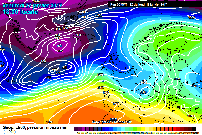
Been avidly watching the GFS ensembles for 47N 13E and they are still swithering on 850hpa temps and edging them slightly up again on the 6Z with precipitation showing for the week from 27th Jan. IF i am reading it correctly one thing I have noticed is that the operational seems to have been a constant mild outlier towards the end for run after run. Can @nozawaonsen or @Jellybeans1000 explain why that happens?
|
|

|
|
|
|
Obviously A snowHead isn't a real person
Obviously A snowHead isn't a real person
|
@robboj, you don't need anymore snow! haha. Locals are reporting the conditions in the region to be the best in years 
|
|
|
|
|
|
Well, the person's real but it's just a made up name, see?
Well, the person's real but it's just a made up name, see?
|
@AthersT, Yep, it sure looks that way from the webcams. Not worried about more snow tbh, just about warmth? This weeks are my favourite conditions by far. Actually I would normally have been there now and only going on 28th as it suited others in the party better. 
|
|
|
|
|
|
You need to Login to know who's really who.
You need to Login to know who's really who.
|
|
|
|
Anyway, snowHeads is much more fun if you do.
Anyway, snowHeads is much more fun if you do.
|
|
|
|
You'll need to Register first of course.
You'll need to Register first of course.
|
|
|
|
|
|
@robboj, I'd interpret that as being the most likely outcome, however (!) the failure of the other ensembles to pick it up means it would be with particularly low confidence.
At that range you are just talking about confidence and probabilities.
For now at least the outlook remains dry, sunny and gradually warming.
Today was a truly stunning blue bird day in the Arlberg. But cold! Pistes in great condition and off piste good too (though still not deep enough to cover all the shrubs and rocks) if you can hike beyond the tracked out areas and have a guide.
|
|
|
|
|
|
|
|
|
@nozawaonsen, Thanks for the intel. How much more snow is needed in the Arlberg for everything offpiste to be covered?
|
|
|
|
|
|
You'll get to see more forums and be part of the best ski club on the net.
You'll get to see more forums and be part of the best ski club on the net.
|
|
@ArlbergMeister, it's pretty good now to be honest. Feels more like early January than mid January. Arle (as in Arlberg) is local dialect for a tree that can't grow straight due to weight of snow. Normally through December the bushes get slowly weighed down by snow as it arrives. Because of the late onset of winter they are still pushing through. Off piste is normally At its best late February early March in terms of snow depth. But like I say it's pretty good right now.
|
|
|
|
|
|
|
|
|
@nozawaonsen, Many thanks! Was there in between Christmas and New Years and had to stick to the pistes. Contemplating a return trip from the US in late Feb or early March.
|
|
|
|
|
|
snowHeads are a friendly bunch.
snowHeads are a friendly bunch.
|
| Whitegold wrote: |
Sierra Nevada ski resort, southern Spain, expecting 2-3ft fresh through Sunday.
|
It always amazes me that Southern Spain can get enough snow for a decent-sized ski resort but Scotland can't really. Given how far North they are, the amount of precipitation and average temperatures of each, it seems staggering. I realise this is me being a weather n00b and there are good reasons it's the case, it just seems weird.
|
|
|
|
|
|
And love to help out and answer questions and of course, read each other's snow reports.
And love to help out and answer questions and of course, read each other's snow reports.
|
|
|
|
|
|
12Z ECM looks quite a bit colder to me than previous runs.
|
|
|
|
|
|
You know it makes sense.
|
| robboj wrote: |
| Been avidly watching the GFS ensembles for 47N 13E and they are still swithering on 850hpa temps and edging them slightly up again on the 6Z with precipitation showing for the week from 27th Jan. IF i am reading it correctly one thing I have noticed is that the operational seems to have been a constant mild outlier towards the end for run after run. Can @nozawaonsen or @Jellybeans1000 explain why that happens? |
That probably means the Control isn't that accurate IMO. I tend to agree with the Control to 7 days and then the Ensemble mean beyond that.
|
|
|
|
|
|
Otherwise you'll just go on seeing the one name:
Otherwise you'll just go on seeing the one name:
|
|
Doesn't seem as if the big change was really a change. Just an interruption of a dry "winter".
|
|
|
|
|
|
Poster: A snowHead
|
|
|
|
Obviously A snowHead isn't a real person
Obviously A snowHead isn't a real person
|
Low height, and the warm Gulf Stream (with blowy winds) that flows off the Scotland coast.
|
|
|
|
|
|
Well, the person's real but it's just a made up name, see?
Well, the person's real but it's just a made up name, see?
|
How's the end of the month looking in FI?
Mostly interested in Austria.
|
|
|
|
|
|
You need to Login to know who's really who.
You need to Login to know who's really who.
|
| Ptspeak wrote: |
| Doesn't seem as if the big change was really a change. Just an interruption of a dry "winter". |
A glitch.
|
|
|
|
|
|
Anyway, snowHeads is much more fun if you do.
Anyway, snowHeads is much more fun if you do.
|
High pressure continues to dominate in the reliable timeframe. Some quite stunning weather in the Alps at present. Still cold for now though this should gradually warm.
Heavy snow heading for the south west corner of Piedmont Sunday into Monday.
At the far end of their runs both GFS toy with an Atlantic influence but too far out to take seriously.
@Ptspeak, in terms of completing transforming snow cover across the northern side of the Alps it was a change.
|
|
|
|
|
|
You'll need to Register first of course.
You'll need to Register first of course.
|
|
@nozawaonsen, how about in terms of losing integrity?
|
|
|
|
|
|
|
|
| nozawaonsen wrote: |
High pressure continues to dominate in the reliable timeframe. Some quite stunning weather in the Alps at present. Still cold for now though this should gradually warm.
Heavy snow heading for the south west corner of Piedmont Sunday into Monday.
At the far end of their runs both GFS toy with an Atlantic influence but too far out to take seriously.
@Ptspeak, in terms of completing transforming snow cover across the northern side of the Alps it was a change. |
A top up would be fantastic but I'll be in Saalbach in a bit over a week and at least I know the place will look wintery and there will be plenty of snow to ski on 
|
|
|
|
|
|
|
|
|
|
|
You'll get to see more forums and be part of the best ski club on the net.
You'll get to see more forums and be part of the best ski club on the net.
|
Just spoke to my daughter in nz - she went snowboarding at mt hutt yesterday. Quite bizarre, I'm in the uk heading to Austria tomorrow.
|
|
|
|
|
|
|
|
My Ruapehu a volcano in central NZ has snow year round. I Could see it from my house in Havelock North glistening whilst we were sweltering mid - Summer. Indeed I can recollect being up the mountain between Xmas and New Year and they had opened the ski field.
Actually booked to go NZ next Xmas and will probably get more snow than Europe!! Though I will stay on the beach. My skiing never starts till end January.
However am about to pack for a weeks off-piste in Grand Massif and am afraid I will be leaving my new 114mm powder skis at home.  Save them for Val & Chamonix March n April. Save them for Val & Chamonix March n April.
|
|
|
|
|
|
snowHeads are a friendly bunch.
snowHeads are a friendly bunch.
|
| nozawaonsen wrote: |
| At the far end of their runs both GFS toy with an Atlantic influence but too far out to take seriously. |
Precipitation has been showing consistently on the ensembles almost everywhere from about 27th/28th right through to the end of the run for a few days now. Would Monday day be classed the reliable timeframe for the first day or two if it's still there?
|
|
|
|
|
|
And love to help out and answer questions and of course, read each other's snow reports.
And love to help out and answer questions and of course, read each other's snow reports.
|
@Weathercam, yep though SW corner of Piedmont still looks well placed. Eastern Pyrenees look like doing well.

|
|
|
|
|
|
|
|
@nozawaonsen, can you just nudge the snow across a bit in the Eastern Pyrenees. Thanks 
|
|
|
|
|
|
You know it makes sense.
|
Lurking and reading the chicken bones, am I right to think that the likelihood in the 3v, next 7 days is cold and clear, warming slightly mid week?
(Just to lower the scientific tone, I ask, simply to decide whether I need a second set of gear in case of rain )
CG
|
|
|
|
|
|
Otherwise you'll just go on seeing the one name:
Otherwise you'll just go on seeing the one name:
|
| Charliegolf wrote: |
Lurking and reading the chicken bones, am I right to think that the likelihood in the 3v, next 7 days is cold and clear, warming slightly mid week?
|
Yes.
|
|
|
|
|
|
Poster: A snowHead
|
See, I do pay attention! Thanks Davidof.
CG
|
|
|
|
|
|
Obviously A snowHead isn't a real person
Obviously A snowHead isn't a real person
|
I'm heading to La Plagne on the 28th Jan. What are the conditions likely to be? I don't want it to be icy as I had for for last years trip to Morzine! 
|
|
|
|
|
|
Well, the person's real but it's just a made up name, see?
Well, the person's real but it's just a made up name, see?
|
|
12z GFS brings the Atlantic in at the start of February with unsettled weather and snow at altitude. Hard to tell at this stage whether to have much faith in this. In the meantime plenty of sunshine and fine weather.
|
|
|
|
|
|
You need to Login to know who's really who.
You need to Login to know who's really who.
|
|
Meteo France going for snow from 27th......if only I could believe them!
|
|
|
|
|
|
Anyway, snowHeads is much more fun if you do.
Anyway, snowHeads is much more fun if you do.
|
ECM also bringing back an Atlantic influence at the end of January.
Still very cold in the shade and once sun is down, but could definitely feel the warmth in the sun in Lech. Still powder to be found if you hike and have a guide.
|
|
|
|
|
|
You'll need to Register first of course.
You'll need to Register first of course.
|
| howiet wrote: |
| Meteo France going for snow from 27th......if only I could believe them! |
we need it, at least another 50cm, we've got a base but need to build a bit of depth before March otherwise it will be early doors except at altitude.
|
|
|
|
|
|
|
|
|
The background for now is a continuation of high pressure. Although there have been repeated indications of a shift to more unsettled weather these have remained at the far end of the output. Until some consensus starts building in the seven day range it's hard to take it seriously at present.
|
|
|
|
|
|
|
|
Has anyone got any recommendations for weather analysis (such as takes place here!) for North America, specifically British Columbia? Also trying to find some temperature and precipitation ensembles.
Thanks!
|
|
|
|
|
|
You'll get to see more forums and be part of the best ski club on the net.
You'll get to see more forums and be part of the best ski club on the net.
|
http://www.tropicaltidbits.com All the way.... Has EC (Public), GEM, GFS, etc
And this is a resource I posted on another forum...
| Quote: |
I guess most people know and often use the big global models GFS, EC, GEM, UKMO, etc for predicting snow for North America. But lots of people don't use mesoscale models. IMHO within a 5 day range, these are the charts to check. Mesoscale charts are charts that use a higher resolution than the big global models. This allows a chance to see more localised falls and smaller systems, where global models are good at looking at the bigger picture. Here's my guide to make sure you don't use the wrong one.
US Models
http://www.pivotalweather.com/model.php?m=nam&p=sfcwind_mslp&rh=2016120100&fh=0&r=conus&dpdt=
NAM North American Mesoscale Model
This is the standard mesoscale chart used by many news weather meterologists and parts of the General public. It is good within 3 days, terrible beyond that. Some meterologists say this chart has poor accuracy, despite its higher resolution. Use caution with this one!
http://graphical.weather.gov/
NDFD National Digital Forecast Database
This has got heaps of graphical forecasts and is used for NWS forecasts. The benefit of this is it uses internal NOAA data and data from the big global models. So this is the model using the data from all the other models.
http://www.spc.noaa.gov/
SPC Storm Prediction Center
This model uses NOAA data to predict severe weather. Good if you want to know when a blizzard is due.
http://wrf.nssl.noaa.gov/
WRF Weather Research Forecast Model
This is another general mesoscale model using a variety of NOAA data. This is often considered to be better than NAM and is my personal choice for forecasting snow.
https://rapidrefresh.noaa.gov/
RAP Rapid Refresh
This is a very short scale model, only going back 6 hours. It predicts the rain radar and is good for knowing when it is going to snow during that day.
http://rapidrefresh.noaa.gov/HRRR/
HRRR High Resolution Rapid Refresh
A Higher Resolution version of RAP
http://www.spc.noaa.gov/exper/sref/
SREF Short Range Forecast Ensemble
Says it in the name, it's an ensemble of forecasts similar to both SPC and NAM forecasts.
http://meteocentre.com/models/model...n&mode=latest&yyyy=latest&mm=latest&dd=latest
HIRESW (also known as HRW-ARW) High Resolution Window Forecast System
This is the mesoscale model from the NCEP using NOAA data and the WRF Model.
Canadian Models (I know less about these)
http://meteocentre.com/models/models.php?lang=en&mod=gemreg
RDPS Regional Deterministic Prediction System
This is the main mesoscale model from the CMC.
http://meteocentre.com/models/models.php?lang=en&mod=cmc_hrdps
HRDPS High Resolution Deterministic Prediction System
This is a higher resolution version of the RDPS.
All these have maximum ranges of 6 hours to 7 days. They are best considered within 5 days of the event, and are most accurate within 3 days of the event. These are great tools if used with global models. As I said at the start, things like the polar vortex, massive cold fronts, arctic nodes, etc should be observed from a global model, but mesoscale models are great for looking at smaller sections of land, smaller storms, localised falls of snow, etc. Some of you might use these tools, but this is just a handy list of most of the NA mesoscale models.
|
|
|
|
|
|
|
|
|
|
|
|
|
|


