Poster: A snowHead
|
Funny old day in the Alps........
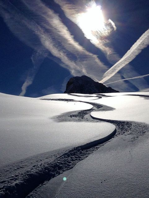
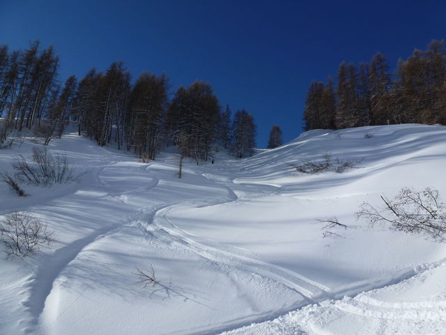
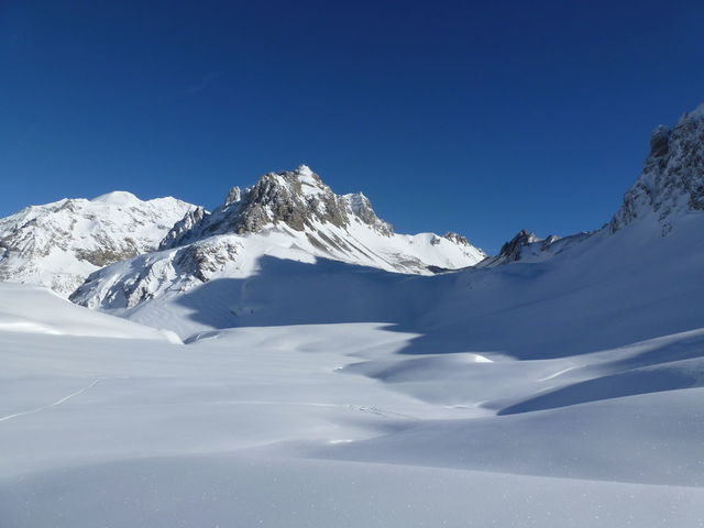
It started snowing just before daybreak and it has basically snowed all day. the temperature on the balcony has dropped 5 degrees since breakfast. The light was flat this morning and turned into a whiteout this afternoon. The stiff breeze has turned into a howling gale - this closed most of the lifts mid afternoon. So a challenging day for an off piste instructor - Aldo (from Evo 2) was more than up to the job. We headed up Chaudanne where we soon realised the wind was quite strong, so our 1st major run was down to the Paravalanche du Glattier (the tunnel about 2km short of Tignes), the light was flat, and the snow was moist and there was quite a crust to break through in places - but a quick shot of expert tips and we were down. A quick trip down on the bus into Boisses and we embarked on the major run of the morning - La Cheminée du Gurran accessed fro the Marais plateau, here is a pic of the couloir (courtesy of our very own skion), I have to say the angle looks much steeper at the top!:
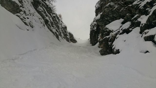
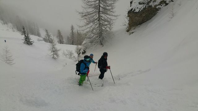
And here's the happy folk admiring their work from below:
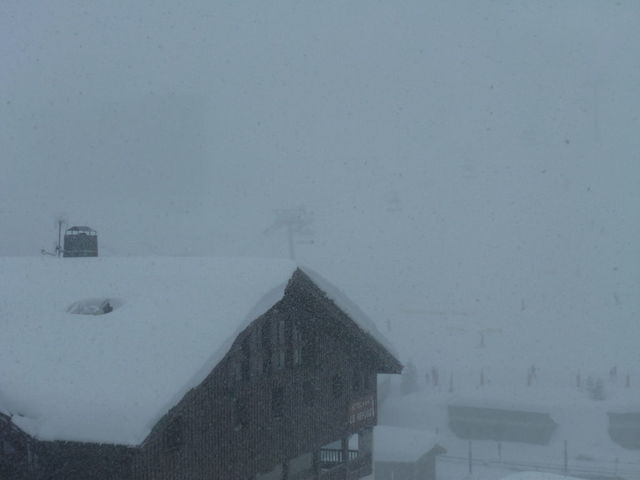
Luckily there was a slight break in the cloud which allowed us to see what we were doing. Sadly this did not last, so after this we completed a few runs close to and on the piste practising the techniques he had showed us for skiing unpredictable off piste. After lunch it was basically a game of beat the closing lifts, so a go on both pomas, Chardonnet and Almes and then a last run up Toviere where it was strong enough to blow you off your feet; in fact the gondola station had about half an inch of snow inside - right up to where the lefties office is  . So we decided discretion was better than valour and came home for a cuppa! As the temperatures cooled through the day the snow was much drier, I suspect tomorrow might be quite a good day once the pisteurs have rearranged all this wind blown snow into good order (don't tell everyone!!). These same temperatures froze my leather Hestras (damp from the morning's exertions) so I could hardly grip my poles. The avalanche risk will be 3 but there will be quite a few cornices around........ . So we decided discretion was better than valour and came home for a cuppa! As the temperatures cooled through the day the snow was much drier, I suspect tomorrow might be quite a good day once the pisteurs have rearranged all this wind blown snow into good order (don't tell everyone!!). These same temperatures froze my leather Hestras (damp from the morning's exertions) so I could hardly grip my poles. The avalanche risk will be 3 but there will be quite a few cornices around........
The snow will continue until tomorrow morning and the wind will howl all night and although it will drop a bit tomorrow expect the top lifts to be closed all day. There will be a brief interlude of sunny periods in the middle of the day but snow will return by mid-late afternoon. It will feel cold in the wind with a freezing level down the valley. Friday will see sunny periods in the morning and sun all afternoon, the freezing level will rise above the villages, so a really nice day hopefully. Saturday will see the clouds thicken through the day and the winds will pick up in the afternoon with a freezing level around 1900m. Then all hell breaks loose! Sunday will see snow most of the day and strong winds aloft, its a bit too early and unpredictable to say how much - but it could be quite a lot (its a lively weather system). Monday is a bit difficult to call - but it will be windy and there is a chance of snow and sunny periods, Tuesday looks like a wild one currently with snow down to 1500m and high winds.
|
|

|
|
|
|
Obviously A snowHead isn't a real person
Obviously A snowHead isn't a real person
|
@chocksaway,
Sounds like a challenging but satisfying day. Thanks for the update and photos- very impressive.
We decided to explore the swimming pool and wellness centre- great facility. You are lucky to have it on your doorstep.
Back on the skis tomorrow until the wind blows us away but looking forward to Friday. As you say, hopefully there will be some great snow around!
|
|
|
|
|
|
Well, the person's real but it's just a made up name, see?
Well, the person's real but it's just a made up name, see?
|
Luckily most of the cloud cleared a bit earlier than expected so we woke to a bright crisp and chilly morning. There was quite a strong wind on high and this strengthened through the day. There was a few bits of mist floating about especially over the Lac Du Chevril, I suspect this scuppered a ski down to the lake for some as it was too dense for a helicopter pick up. Today was a mix of piste cruising (they are in excellent shape) and some gentle off piste. There is quite a lot of soft stuff about, medium weight - which is not surprising given the speed it arrived last night so freshtracks for all even if it was not champagne powder!! We tried to get to Grand Pre, but Borsat was closed because of avalanche work and Marmottes Express was having a temperamental morning which meant the queues were huge, so back to Val Claret and a trip up Lanches, where the snow on the side was very good. The winds picked up just after lunch and the cloud has progressively got worse, and it started snowing lightly at about half past three.
This snow will continue until around midnight when the clouds will progressively clear and the sun should shine for most of the day tomorrow - there may be the odd cloud scuttling around the peaks. With a freezing level of 2600m it will feel very pleasant - so enjoy your last day or enjoy it anyway because its down hill from Saturday. There may be the odd glimpse of the sun on Saturday morning but it will cloud over quite quickly and the winds will be strong in the afternoon, a good day to stop in your own valley! It will start snowing down to 1600m or so just after darkness falls, which hopefully means that most people will get here before it starts as the Savoie Transport Elves are forecasting that 36000 vehicles will pass between Albertville and Moutiers on Saturday, with 26000 gong the other way. Last years biggest forecast was 37000 IIRC, so there are going to be traffic jams, the advice would be to get here as soon as possible. Snow chains or winter tyres will be required by the late arrivals. Sunday looks like a whiteout with snow and high winds, the snowline will drop from Boisses to Bourg during the day. Calling Monday and Tuesday is currently quite difficult but windy and snowy (down to 1500m) would be a fair bet, pretty much the same for Wednesday, but there may be the odd sunny spell. The detail on these 3 days will change, but between now and Wednesday we could get anywhere between 30 and 70cm of snow depending on where the most active parts of the weather systems pass.
|
|
|
|
|
|
You need to Login to know who's really who.
You need to Login to know who's really who.
|
Thanks as always @chocksaway, so helpful.
We spent the day around Glacier and Madeleine with the weather starting to turn about 2pm. Thanks to the very accurate weather info on here yesterday we knew we better start scuttling back to Tinges and sure enough the flat light took hold so the usual mix of strugglers and fastboys made it an interesting journey home via Rhone Alpes and Henri.
All in all a fabulous day- we rarely get sun and such good snow. Looking forward to tomorrow- I think we will try to go over to Fornet as we haven't been over there yet this week and it sounds like the day for a long distance cruise.
|
|
|
|
|
|
Anyway, snowHeads is much more fun if you do.
Anyway, snowHeads is much more fun if you do.
|
|
|
|
You'll need to Register first of course.
You'll need to Register first of course.
|
|
|
|
|
|
|
|
|
|
|
|
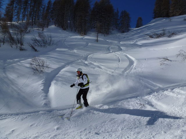
Cracking second photo @Tigski, I expect you will tell me it was taken on a smartphone...
|
|
|
|
|
|
You'll get to see more forums and be part of the best ski club on the net.
You'll get to see more forums and be part of the best ski club on the net.
|
|
@Grinning, iPhone 5c but all to do with seeing the opportunity😀
|
|
|
|
|
|
|
|
|
Geneva is now forecasting fog in the morning - standby for a few delays there.......
|
|
|
|
|
|
snowHeads are a friendly bunch.
snowHeads are a friendly bunch.
|
It was certainly a beautiful morning. We saw those vapour trails and the 'rainbow clouds' (apologies not to know the technical name for them). We skied over to Fornet and around the glacier. Stunning morning and fantastic conditions.
Thanks for the fab photos and @Tigski, @chocksaway,. I'd love to do that sometime but I am afraid it will have to be next lifetime for me!
Thanks for all the information and we look forward to returning to the EK after Easter. Stay safe all.
|
|
|
|
|
|
And love to help out and answer questions and of course, read each other's snow reports.
And love to help out and answer questions and of course, read each other's snow reports.
|
|
|
|
|
|
We are heading back to paradise on March 12th, booked tonite, yippee 
|
|
|
|
|
|
You know it makes sense.
|
A mostly sunny morning this morning, but the cloud has thickened progressively through the afternoon and the wind has started to pick up. Just a quick whizz on piste today - still in excellent condition apart from the odd ridge when the wind has scoured some of the snow away. A last day of reasonably empty pistes, looking at the number of traffic jams down the valley. I imagine there will be some fractious tourists about tonight - especially those that diverted from Chambery this morning to then face the thick of the traffic.
The cloud will thicken even more through tonight, and it will start snowing around midnight and there will be a gusty wind - this will continue throughout tomorrow, it will mostly be light snow so maybe 10cm or so in the next 24 hours. Of course new snow and lots of wind means a rise in the Avalanche Risk to Level 3 - considerable. I suspect transfer times for those leaving tomorrow may creep forward. As the weather for the next week is very unsettled the timings of the snow and wind are going to vary - so stay tuned - its going to be a bumpy old ride. On Monday it looks less windy and there may be a glimpse of the sun in the morning but snow down to 1500m will appear in the afternoon and this will continue through Tuesday, but the wind will return by Tuesday morning - another whiteout I fear. Wednesday will be more showery so we may see the sun between fast moving snow showers, it will also feel bitter in the wind with the freezing level down in Bourg. After this it remains unsettled but hopefully there will be a little less wind.
For those travelling tomorrow, the whole of the UK will be showery and very windy around the showers but, with the exception of Leeds Bradford for short periods, the winds should be within crosswind limits. Over here will be pretty much the same wet rollercoaster of a ride, the only weather issue that could cause problems are at Chambery where a mixture of the visibility in heavy showers and the gusty winds swirling round the mountains around those showers could cause issues, hopefully not as bad as today's fog. If you are on a boat across the Channel - hang on!
|
|
|
|
|
|
Otherwise you'll just go on seeing the one name:
Otherwise you'll just go on seeing the one name:
|
@chocksaway, I love your posts - Always my first stop on snowheads these days! 
|
|
|
|
|
|
Poster: A snowHead
|
|
Looks like the storm has arrived. @chocksaway, (aka John Kettley) strikes again. Just read that Chambery is currently closed due to snowstorm and high winds.
|
|
|
|
|
|
Obviously A snowHead isn't a real person
Obviously A snowHead isn't a real person
|
|
|
|
Well, the person's real but it's just a made up name, see?
Well, the person's real but it's just a made up name, see?
|
@stewart woodward, Cheers Stewart. Finally snowing properly over the border as well 
|
|
|
|
|
|
You need to Login to know who's really who.
You need to Login to know who's really who.
|
| Quote: |
(aka John Kettley)
|
With my accent it would have to be Paul 'udson!!
And it was a mixed bag at Chambery again, with a few aircraft landing in the wrong place. However, up in Tignes even the master aviators gave up:

The weather was a bit later arriving than we thought, but by breakfast time it was snowing lightly and early afternoon it went mad:
That lasted for about 90 minutes and it has now stopped snowing (5 o'clock). the snow at 2100m was quite heavy as it was quite warm, up higher it will be better, if a bit (or a lot) windblown With the wind and the snow it didn't look great so I took a day off - the lower slopes were busy as I suspect it was quite unpleasant above 2500m.
Forecasting exactly what is going to happen is getting more difficult, the atmosphere over the Alps for the next week could best be described as chaotic and the different forecasters are disagreeing But after a few sunny spells in the morning it will cloud over and we will have light snow by lunchtime, this will become heavy later in the afternoon when it will become increasingly windy (watch for the links between Val and Tignes closing early). The snowline will be below les Brevieres. Tuesday will be similar to Monday afternoon a windy white out, but if you think that is bad wait for Wednesday when the winds will be gale force and the freezing level will be at 200m. If this comes to pass it will be brutal, despite a chance of a fast moving sunny period. Thursday and Friday will be mainly snowy, but the wind will abate and the temperatures will rise a degree or 2. I would hazard a guesstimate of between 40 and 60 cm between now and late Wednesday, but that could vary significantly as this witches cauldron bubbles away!
|
|
|
|
|
|
Anyway, snowHeads is much more fun if you do.
Anyway, snowHeads is much more fun if you do.
|
| chocksaway wrote: |
| If you are on a boat across the Channel - hang on! |
It wasn't that bad, ferries are pretty big.
|
|
|
|
|
|
You'll need to Register first of course.
You'll need to Register first of course.
|
The curtains were drawn back to find a partly obscure sky, 10cm of new snow in the village and 20cm higher and the police towing cars from the drop off slots outside chez chocks! Although one lucky soul did scuttle out of the block very quickly before the cops got back from the pound. There was good skiing to be had all over the resort, although the wind up high meant I went lower and found some good fresh snow around the Bellevarde - not quite deep enough to avoid bumping off the hard layer beneath. After coffee in La Daille I ventured down to Boisses and Brevieres where the new snow was not so deep as I suspect the early falls were close to rain. At about 1.30pm the wind started to pick up dramatically and has done so all afternoon, by 4.30pm the only way back to Val was the Combe Folle drag, back to Tignes looks like a bus as even Tommeuses had to close early. I think some snow is falling now but its difficult to tell with the wind blowing stuff off the roofs.
The wind and snow will continue through the night and through tomorrow with potentially 30-40cm of snow over the next 24 hours, it will feel very cold in the wind despite the freezing level being at around 1900m by Tuesday lunchtime. This may mean it will be sleeting close to Brevieres tomorrow. So head for the trees and stay relatively close to home, as connecting lifts may well close in the afternoon (if they open them in the first place). The avalanche risk will rise to 4 by midday. As I said yesterday, getting accurate timings of the weather is very difficult, the isobars are wiggling round like a pot full of spaghetti! Wednesday's forecast is still open to debate as it changes every time they run the computer models but lets settle for very windy, very cold (freezing level at 600m) and some snow - it may be heavy, it may be light and it may even stop after lunch....... Thursday looks more benign, with the wind and snow abating. Friday brings more snow and winds picking up in the afternoon. I will leave Saturday's weather down to Frank Sinatra: "There may be trouble ahead, but while there's music and moonlight and love and romance, Let's face the music and dance"
|
|
|
|
|
|
|
|
Well the wind died down a bit overnight and it basically stopped snowing whilst we were asleep, those capricious isobars opened up and the main band of snow missed us. So all in all we did not get much snow overnight but now (1700hrs) it is absolutely honking down with snow. All in all this was quite good as I was off piste with Evo 2 today, so actually conditions were not too bad this morning. We started with the 'back' of Campanules as a warm up before heading up Lanches, where there was a stiff to strong breeze. There was a vague glimpse of the sun which was nice as we could then see what we were doing down one of the couloirs on the nort face of the Petite Balme - there was plenty of mid weight snow - which was particularly welcome when I ended up upside down. As we got down into Val Claret the expected bad weather started to arrive. By the time we had hiked up to the classic entrance of the Chardonnet Bowl the light was not great - but the snow was better. After lunch the weather deteriorated and we headed towards Tignes Les Brevieres via the Cheminée du Gurran, and then one last run through the trees which seemed to keep jumping in front of me.
The weather, hmmmmmmm still highly unpredictable but here's the best attempt. It will snow through the night, heavily until after dark and then more lightly after midnight, the winds will pick up, but not as much as expected yesterday. The freezing level will drive down the hill faster than a local taxi (!) so tomorrow will definitely be a layer or 2 colder than today. Although the wind will drop through the morning - watch out for frost nipped faces. There may be a glimpse of the sun around lunchtime between light snow showers. BUT the Avalanche Risk is a solid 4 - be careful, tonigts heavy snow and wind will mean a lot of work for the pisteurs in the morning(a progressive opening of the lifts is on the cards) and when the sun comes out just think twice or 3 times before diving into that powder field. Thursday still looks a bit more benign with less wind and sunny periods through the day, it will still be cold though. A chance of a flocon or 2 in the afternoon. Friday looks quite wild with the winds increasing and snow down to 1600m for most of the day, Saturday is still a long way off in weather terms, a bit warmer but a mix of snow and sunny periods, the snow line will rise to the dam mid morning and then fall in the afternoon, if you are leaving, Friday night would be the best time or as soon after 5am that you can manage. Snow tyres or chains will be the order of the day!
|
|
|
|
|
|
|
|
|
Well, having returned from Les Arcs on Saturday I just booked myself an apartment in Tignes from the 12th March for a week. I can't wait
|
|
|
|
|
|
You'll get to see more forums and be part of the best ski club on the net.
You'll get to see more forums and be part of the best ski club on the net.
|
|
Lots of snow overnight, still waiting for the scores on the doors. Blowing a gale and -11 on the balcony. Its going to be a morning for the hardy - once some lifts open, no forecasts showing yet.
|
|
|
|
|
|
|
|
|
|
|
snowHeads are a friendly bunch.
snowHeads are a friendly bunch.
|
After 15-30cm (low/high) in the 24 hours to 8am there was a lot of snow out here. Unfortunately it was blowing a gale and continued to snow lightly trough the day, making it very difficult. So as a group we decided to do some practical transceiver training out on the Palafour, but not in the teeth of the gale.. There was the occasional peep at the sun so we did get couple of off piste runs in - the snow was remarkably good, on piste likewise, but again it bumped up during the day. None of the links or high lifts opened in either Tignes or Val D'Isere - a poor week fr the altitude restaurants.
The snow will continue until the small hours of tomorrow and the wind will progressively quieten. So tomorrow may be the best day of the week as we are expecting some sunny periods in the morning, but it will still be very cold. The cloud will thicken through the evening and it will start snowing by the middle of the night. Friday will be snowy and the wind will blow again from early afternoon. The snow level will be down in the Valley, another survival day. Saturday will start with light snow and this will get thicker through the day, the winds should also pick up in the afternoon, but the snow level will rise to about 1300m. So if you are driving leave early and if you do not have snow tyres make sure you have chains, I am almost certain the police will be stopping anybody leaving without them. Sunday will be snowy and windy with the snow line rising a bit. The unsettled weather looks like continuing right into next week.
|
|
|
|
|
|
And love to help out and answer questions and of course, read each other's snow reports.
And love to help out and answer questions and of course, read each other's snow reports.
|
|
We saw the photo. Of the entrance to the Panorama on the Tignes FB page. Impressive.
|
|
|
|
|
|
|
|
Hi Tignes locals, I don't suppose you know how busy resort gets during European Snow Pride I've just realised it is on the week I have booked 
|
|
|
|
|
|
You know it makes sense.
|
|
I'm there the same week, and I was a few years ago. Aside from a lot of extra flouncing in the Folie Douce it wasn't noticeably busier than usual.
|
|
|
|
|
|
Otherwise you'll just go on seeing the one name:
Otherwise you'll just go on seeing the one name:
|
|
Great updates Chocks, fair play, even though I won't be joining you good to see an honest account of conditions
|
|
|
|
|
|
Poster: A snowHead
|
|
Ok great thanks HoneyBunny, I'm far too square for the Folie anyway
|
|
|
|
|
|
Obviously A snowHead isn't a real person
Obviously A snowHead isn't a real person
|
@Minion1980, Its somewhere between 300 and 500 folks celebrating each year, it generates a lot of media attention but in terms of resort numbers its a drop in the ocean. As HB says the Folie and one or 2 places will be busier but that's it.
Meanwhile its a glorious but cold morning, wrap up warm and enjoy it while it lasts.
Oh and thanks to the Mark Warner delivery lorry for waking us all up at 6.30 this morning buy getting stuck broadside across the road - top tip revving the guts out of the thing will not help!!!
|
|
|
|
|
|
Well, the person's real but it's just a made up name, see?
Well, the person's real but it's just a made up name, see?
|
|
@HoneyBunny, @Minion1980, thats our week too.
|
|
|
|
|
|
You need to Login to know who's really who.
You need to Login to know who's really who.
|
A game of two halves (ooo jumpers for goal posts....). But just a word of caution from last night, a lady walked too close to the edge of the Lac de Tignes last night and the ice broke - luckily the water was only 50cm deep. There are a number of springs that 'spring' into the lake all winter long - and therefore make the ice thin or non existent - stick to the central path.
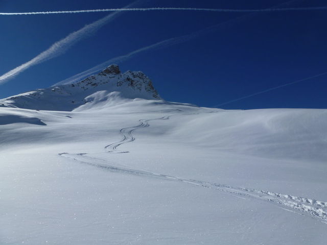
We awoke to glorious blue skies, so after a poor week there were predictably long queues in the villages until about 0945 when people were dispersed around the mountains of Tignes and Val D'Isere. Luckily Chaudanne was not too busy and there were no crowds down Glattier:
And here's Tigski at the bottom after a perfect set of tracks:
Following this we were having too much fun to take pictures, but we took in the off piste run down from the Eye of the Needle, and then around Grattalu and the top of the Palet drag - all light snow and untracked. Just as we reached the bottom of the second 'Tour de Palet' they opened Col de Ves - to a huge whoop of approval. Unfortunately, the clouds had started to fill the sky and the light deteriorated, but the snow was fabulous. The pistes are also in great condition having been bashed to perfection last night.
The weather remains unpredictable, but the sky is now obscured and the cloud has obscured the peaks. It will soon start snowing (about going to the pub time) and this will continue through the night, with perhaps a small lull around midnight. The snowline will be way down the valley. It will snow more or less through tomorrow with a low snowline, there might be the odd break and the winds will be strong in the afternoon. For transfer day, it will basically snow all day and be windy, the snow line will rise to around St Foy village by midday. Snow tyres or chains will be obligatory I should imagine, might be your last chance to buy them tonight.... The Savoie authorities are expecting 35000 vehicles coming up the hill and 30000 going down - so pretty much as last week but with bad weather - remember what Frank Sinatra said earlier in the week........There will be traffic jams in all the usual places, but after last year expect the police to be ruthless in applying the rules. Sunday will be a mix of snow showers and fast moving sunny periods in the wind. Monday will be the same but with much less wind. After that it will still be mixed weather but at the moment it looks better than this week, but there is the potential for quite a strong 'Genoa Low' around Tuesday, this are of low pressure often brings a lot of snow on a from the south east - where Le Fornet can get a significant amount of snow and the rest of Val D'Isere and Tignes get much less, regular readers will remember that this happened quite a lot last year.
|
|
|
|
|
|
Anyway, snowHeads is much more fun if you do.
Anyway, snowHeads is much more fun if you do.
|
|
Great photos @chocksaway and as always a brilliant update.
|
|
|
|
|
|
You'll need to Register first of course.
You'll need to Register first of course.
|
|
|
|
|
|
^, ^^, thanks folks, yes despite all the doom and gloom in the Press we are having a great, if a little unusual (in weather terms) season. Still not been to the Pool or the Gym so it must be good.
This morning is gloomy with low light conditions and light snow which started a couple of hours ago, should make the technique lesson all the more interesting.......
|
|
|
|
|
|
|
|
|
Thanks for the photos and updates. Me and the Mrs will be arriving on the slopes of Tignes on the 22nd Feb. Fingers crossed for good snow and blue sky. It will be my first ski trip outside of Italy's Dolomite's, so really looking forward to it!
|
|
|
|
|
|
You'll get to see more forums and be part of the best ski club on the net.
You'll get to see more forums and be part of the best ski club on the net.
|
The light snow of this morning soon turned moderate to heavy and this has continued all day, added to the wind I was glad I was having a technique lesson as it meant my mind was on something other than the weather. If you could have seen them the pistes are in excellent condition, but with this level of snowfall it was bumping up quite badly. I didn't see anyone off piste but at some stage next week there are going to be some great if potentially dangerous pitches on the other side of the poles. The avalanche risk for tomorrow is level 4.
This snow will continue through the night, but it will get lighter, there may be a lull in the snow tomorrow morning but it will be back later, the winds will also pick up significantly tomorrow but the snow level will rise to about 1400m. So tomorrow for those in resort it will be bleak and cold, for those leaving you will need snow chains or snow tyres whether you are in Val D'Isere or Tignes. Please don't try and leave without them as you will just delay everybody else. Sunday will be pretty much like Saturday - with the intensity of the snow coming and going. Between now and Sunday evening we are expecting something like 40-60cm of snow. On Monday most of the wind will have gone but there will be light snow showers all day, Tuesday will be a mixed bag of snow showers and sunny periods but still cold for the time of year and it will be a south easterly courtesy of the Genoa low - Le Fornet anyone?? (hint see yesterdays forecast). Wednesday and Thursday look better with more sun - so take care as the powder fever sets in.
I think we already know that tomorrow is going to be difficult on the roads - both ways. So whether you are self drive, private transfer or bus I would prepare yourself with snacks and drinks, luckily the freezing level is going to rise from today so once you are onto the main roads down past Bourg then the going should be easier, but as there is only one way out it only takes a minor skid to turn the roads into a catastrophe. The striking workers from carbon Savoie (the stinky factory between Moutiers and Albertville) are also going to be demonstrating at the peage near Albertville - another potential issue, I'm afraid.
For those flying it will be much better than today (Geneva has been regularly closing the runway for snow clearance this afternoon). All the UK airports may see rain showers and from Leeds north there is a chance of sleet showers in the afternoon, which could slow things up a little ooooop north. Over here it will be showery (but of rain) and very windy so expect a bumpy ride especially late in the afternoon. The currenty Chamber forecast is only valid until 1300hrs tomorrow so potentially with the proximity of the mountains there could be issues around any showers with turbulence, if the wind rises to the speed forecast at Lyon. That's it, much patience on the roads but for those arriving from mid week onwards it is looking goooood.
|
|
|
|
|
|
|
|
|
|
|
|
|


 [/img]